
The Kalahari Desert is a large semi-arid sandy savanna in Southern Africa extending for 900,000 square kilometres (350,000 sq mi), covering much of Botswana, as well as parts of Namibia and South Africa.

An endorheic basin is a drainage basin that normally retains water and allows no outflow to other, external bodies of water, instead, the water drainage flows into permanent and seasonal lakes and swamps that equilibrate through evaporation. Endorheic basins also are called closed basins, terminal basins, and internal drainage systems.
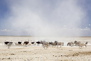
Etosha National Park is a national park in northwestern Namibia and one of the largest national parks in Africa. It was proclaimed a game reserve in March 1907 in Ordinance 88 by the Governor of German South West Africa, Friedrich von Lindequist. It was designated as Wildschutzgebiet in 1958, and was elevated to the status of a national park in 1967 by an act of parliament of the Republic of South Africa. It spans an area of 22,270 km2 (8,600 sq mi) and gets its name from the large Etosha pan which is almost entirely within the park. With an area of 4,760 km2 (1,840 sq mi), the Etosha pan covers 23% of the total area of the national park. The area is home to hundreds of species of mammals, birds and reptiles, including several threatened and endangered species such as the black rhinoceros. Sixty-one black rhinoceros were killed during poaching in Namibia during 2022, 46 of which were killed in Etosha.

Natural salt pans or salt flats are flat expanses of ground covered with salt and other minerals, usually shining white under the sun. They are found in deserts and are natural formations.

The Etosha Pan is a large endorheic salt pan, forming part of the Cuvelai-Etosha Basin in the north of Namibia. It is a hollow in the ground in which water may collect or in which a deposit of salt remains after water has evaporated. The 120-kilometre-long (75-mile-long) dry lakebed and its surroundings are protected as Etosha National Park, Namibia's second-largest wildlife park, covering 22,270 square kilometres (8,600 sq mi). The pan is mostly dry but after a heavy rain it will acquire a thin layer of water, which is heavily salted by the mineral deposits on the surface.

Burchell's zebra is a southern subspecies of the plains zebra. It is named after the British explorer and naturalist William John Burchell. Common names include bontequagga, Damaraland zebra, and Zululand zebra. Burchell's zebra is the only subspecies of zebra which may be legally farmed for human consumption.

Ontario Lacus is a lake composed of methane, ethane and propane near the south pole of Saturn's moon Titan. Its character as a hydrocarbon lake was confirmed by observations from the Cassini spacecraft, published in the 31 July 2008 edition of Nature. Ontario Lacus has a surface area of about 15,000 square kilometers (5,800 sq mi), about 20% smaller than its terrestrial namesake, Lake Ontario in North America. In April 2012, it was announced that it may be more like a mudflat or salt pan.
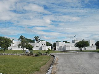
Namutoni is a restcamp on the edge of Etosha pan in the Oshikoto Region in northern Namibia. It is one of the entrance gates to Etosha National Park.
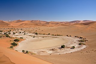
Sossusvlei is a salt and clay pan surrounded by high red dunes, located in the southern part of the Namib Desert, in the Namib-Naukluft National Park of Namibia. The name "Sossusvlei" is often used in an extended meaning to refer to the surrounding area, which is one of the major visitor attractions of Namibia.

Tourism in Namibia is a major industry, contributing N$7.2 billion to the country's gross domestic product. Annually, over one million travelers visit Namibia, with roughly one in three coming from South Africa, then Germany and finally the United Kingdom, Italy and France. The country is among the prime destinations in Africa and is known for ecotourism which features Namibia's extensive wildlife.

Angolan mopane woodlands are situated in southwestern Angola, extending into northern Namibia. This ecosystem surrounds Etosha Pan, which is considered a separate ecoregion. The mopane trees are the main type of vegetation.

Hyphaene petersiana, the real fan palm or makalani palm, is a palm tree native to the subtropical, low-lying regions of south central Africa.
Oshigambo is a settlement in the Oshikoto Region of northern Namibia. It is situated on the banks of Oshigambo River east of the Etosha pan.
The Oshigambo River is an ephemeral river in central northern Namibia, flowing into Etosha Pan. It almost never carries surface water but flowed and broke its banks in 2006, flooding Oshigambo, a village it cuts through. Students at the Oshigambo High School were affected by the 2011 flood. The bridge connecting the female hostel to the school was under water due to the heavy rains. The flooding claimed several lives during the past few years.
Okatana is an ephemeral river in the north of Namibia. It forms part of the Cuvelai basin. It has two channels, one running through Oshakati, serving as the boundary between the constituencies of Oshakati West and Oshakati East; the other running east of town. The two channels rejoin south of Oshakati, and the river flows into the Etosha pan. The river provides a source of water to people who leave nearby the river and food during rainy season. During rainy season it affects the community economically, socially and educationally. The ways are cut off; schools are closed due to this river. This is always made difficult for the students and teachers to close this river.
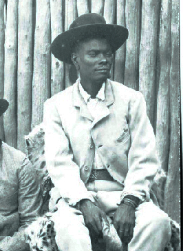
Nehale lya Mpingana was Omukwaniilwa of Ondonga, a subtribe of the Owambo, in German South West Africa. Their tribal area is situated around Namutoni on the eastern edge of Etosha pan in today's northern Namibia. He reigned over the eastern part of the Ondonga area from 1884 until his death; Kambonde II kaMpingana was chief of the western part.

Lake Oponona is a natural lake in the Uuvudhiya Constituency in the Oshana Region of northern Namibia. It is situated about 70 kilometres (43 mi) from Etosha Pan and is the largest lake in the Cuvelai Basin.

Lijdensrust, officially the Republic of Lijdensrust, was a short-lived Boer republic in the area of present-day Namibia. Declared on 20 October 1885, it was originally named Upingtonia, but changed its name soon after as the reason for its original name proved worthless. In 1887, it was merged into German South-West Africa.
The Cuvelai-Etosha Basin is a transboundary wetland area shared by Angola and Namibia extending over 450 kilometres from north to south. Covering almost 160,000 km2, the widest point of the basin is along the Angola-Namibia border from the Kunene River east to the Okavango River.
