The San Diego and Arizona Railway was a 148-mile (238 km) short line U.S. railroad founded by entrepreneur John D. Spreckels, and dubbed "The Impossible Railroad" by engineers of its day due to the immense logistical challenges involved. It linked San Diego, its western terminus, with El Centro, its eastern terminus, where passengers could connect with Southern Pacific's transcontinental lines, eliminating the need to first travel north via Los Angeles or Riverside.

The San Diego and Imperial Valley Railroad (SD&IV) is a class III railroad operating freight rail service in the San Diego area, providing service to customers in the region and moving railcars between the end of the BNSF Railway in downtown San Diego and the Mexico–United States border in San Ysidro. It was established in October 1984 and is owned and operated by Genesee & Wyoming.
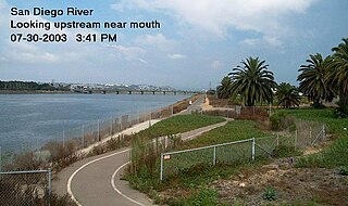
The San Diego River is a river in San Diego County, California. It originates in the Cuyamaca Mountains northwest of the town of Julian, then flows to the southwest until it reaches the El Capitan Reservoir, the second-largest reservoir in the river's watershed at 112,800 acre-feet (139,100,000 m3). Below El Capitan Dam, the river runs west through Santee and San Diego. While passing through Tierrasanta it goes through Mission Trails Regional Park, one of the largest urban parks in America.

A sag pond is a body of fresh water collected in the lowest parts of a depression formed between two sides of an active strike-slip, transtensional or normal fault zone.

El Capitan Reservoir is a reservoir in central San Diego County, California. It is in the Cuyamaca Mountains, about 30 miles (48 km) northeast of the city of San Diego and two miles northwest of the town of Alpine.

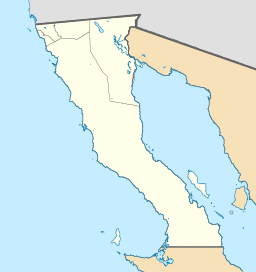
The Coyote Mountains are a small mountain range in San Diego and Imperial Counties in southern California. The Coyotes form a narrow ESE trending 2 mi (3.2 km) wide range with a length of about 12 mi (19 km). The southeast end turns and forms a 2 mi (3.2 km) north trending "hook". The highest point is Carrizo Mountain on the northeast end with an elevation of 2,408 feet (734 m). Mine Peak at the northwest end of the range has an elevation of 1,850 ft (560 m). Coyote Wash along I-8 along the southeast margin of the range is 100 to 300 feet in elevation. Plaster City lies in the Yuha Desert about 5.5 mi (8.9 km) east of the east end of the range.
The San Antonio–San Diego Mail Line, also known as the Jackass Mail, was the earliest overland stagecoach and mail operation from the Eastern United States to California, in operation between 1857 and 1861. It was created, organized and financed by James E. Birch the head of the California Stage Company. Birch was awarded the first contract for overland service on the "Southern Route", designated Route 8076. This contract required a semi-monthly service in four-horse coaches, scheduled to leave San Antonio and San Diego on the ninth and the 24th of each month, with 30 days allowed for each trip.

East County is a region of San Diego County, California, east of San Diego.

The Mountain Empire is a rural area in southeastern San Diego County, California. The Mountain Empire subregion consists of the backcountry communities in southeastern San Diego County. The area is also sometimes considered part of the East County region of San Diego County.
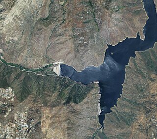
El Capitan Dam is an embankment dam or Hydraulic fill dam on the San Diego River in southern California. The dam forms the 112,800-acre-foot (139,100,000 m3) El Capitan Reservoir and serves mainly to supply water to the city of San Diego as well as providing flood control. The dam is connected to the San Diego municipal water system via the El Capitan Pipeline, which extends approximately 30 miles (48 km) to the city. It is the second largest storage facility in San Diego's water supply system, after San Vicente Dam.
The 1892 Laguna Salada earthquake occurred at . It had an estimated moment magnitude of 7.1–7.2 and a maximum perceived intensity of VIII (Severe). The shock was centered near the Mexico–United States border and takes its name from a large dry lake bed in Baja California, Mexico. There were no reported casualties, but the event affected the then largely-uninhabited areas of northern Mexico and Southern California.
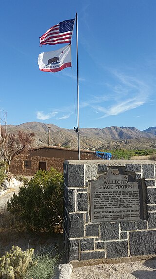
Vallecito, in San Diego County, California, is an oasis of cienegas and salt grass along Vallecito Creek and a former Kumeyaay settlement on the edge of the Colorado Desert in the Vallecito Valley. Its Spanish name is translated as "little valley". Vallecito was located at the apex of the gap in the Carrizo Badlands created by Carrizo Creek and its wash in its lower reach, to which Vallecito Creek is a tributary. The springs of Vallecito, like many in the vicinity, are a product of the faults that run along the base of the Peninsular Ranges to the west.
Palm Spring Station is a former Butterfield Overland Mail stagecoach station located at Palm Spring in San Diego County, California. This station built in 1858 by division agent, Warren F. Hall is commemorated by California State Historical Marker Number 639 Palm Spring.

Palm Spring is a spring in Mesquite Oasis, a desert oasis amidst a mesquite thicket and a few palms, close to Carrizo Creek, within the Anza-Borrego Desert State Park in San Diego County, California.
Carrizo Creek Station is a former stage station of the San Antonio-San Diego Mail Line and Butterfield Overland Mail, located in Imperial County, California, just east of the San Diego County line. It lies within the boundaries of the Anza-Borrego Desert State Park just west of the Carrizo Impact Area. Its site is located along the bank of Carrizo Creek.
The Carrizo Creek and Carrizo Wash in California are a stream and an arroyo in San Diego County, California, and Imperial County, California.
San Felipe Creek is a stream in Imperial and San Diego Counties of California. It arises in the Volcan Mountains of San Diego County 33°11′57″N116°37′35″W, and runs eastward, gathering the waters of most of the eastern slope of the mountains and desert of the county in the San Sebastian Marsh before it empties into the Salton Sea. It is probably the last remaining perennial natural desert stream in the Colorado Desert region. In 1974, the San Felipe Creek Area was designated as a National Natural Landmark by the National Park Service.

Carrizo Gorge is a valley in the Jacumba Mountains in San Diego County, California. Its mouth is at an elevation of 1,411 feet (430 m), where it widens out to become Carrizo Canyon, 1 mi (1.6 km) northeast of Palm Grove. Its head is located in the Jacumba Mountains, 1.5 mi (2.4 km) north of Round Mountain, at an elevation of 2,600 ft (790 m) at 32°39′38″N116°11′28″W.
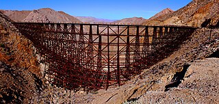
Goat Canyon Trestle is a wooden trestle in San Diego County, California. At a length of 597–750 feet (182–229 m), it is the world's largest all-wood trestle. Goat Canyon Trestle was built in 1933 as part of the San Diego and Arizona Eastern Railway, after one of the many tunnels through the Carrizo Gorge collapsed. The railway had been called the "impossible railroad" upon its 1919 completion. It ran through Baja California and eastern San Diego County before ending in Imperial Valley. The trestle was made of wood, rather than metal, due to temperature fluctuations in the Carrizo Gorge. By 2008, most rail traffic stopped using the trestle.
Goat Canyon is a valley in San Diego County, California, United States, located within the Carrizo Gorge in the Jacumba Mountains. The rock forming the canyon is crystalline basement. One feature of the canyon is a dry waterfall. The canyon is bridged by a wooden railroad trestle, the Goat Canyon Trestle, which is the world's largest curved all-wood trestle. The canyon is accessible by trail by traveling west from Mortero Palms.