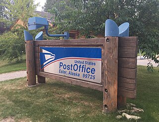
Ester is a census-designated place (CDP) in Fairbanks North Star Borough, Alaska, United States. It is part of the Fairbanks, Alaska Metropolitan Statistical Area. The population in the CDP was 2,422 at the 2010 census, although there are only around 12 houses located inside of the village, the rest are in the surrounding area. The Ester Camp Historic District is a historic district listed on the National Register of Historic Places. Ester was founded as a gold mining camp in the early 1900s, and the economy has focused on mining and services for miners. The Ester Volunteer Fire Department, John Trigg Ester Library, Ester Historic Society and Ester Post Office serve residents in Ester and surrounding areas. There is also a convenience store and secular chapel on the outskirts of the village. Many artists, writers, and musicians reside in Ester.

Fox is a census-designated place (CDP) in Fairbanks North Star Borough, Alaska, United States. It is part of the Fairbanks, Alaska Metropolitan Statistical Area. At the 2010 census the population was 417, up from 300 in 2000.

Nome is a city in the Nome Census Area in the Unorganized Borough of the US state of Alaska. The city is located on the southern Seward Peninsula coast on Norton Sound of the Bering Sea. It had a population of 3,699 recorded in the 2020 census, up from 3,598 in 2010. Nome was incorporated on April 9, 1901. It was once the most-populous city in Alaska. Nome lies within the region of the Bering Straits Native Corporation, which is headquartered in Nome.

Chicken is a tiny unincorporated village in Southeast Fairbanks Census Area, Alaska. It is a community founded on gold mining, and is one of the few surviving gold rush towns in Alaska. The population was 12 at the time of the 2020 census, up from 7 in 2010. However, usually year round, there are 17 inhabitants. Due to mining, Chicken's population peaks during the summer. It has frequently been noted on lists of unusual place names. There is a cafe with gas station, a small hotel, an RV park, a small general store and a saloon located at Chicken.

A gold rush or gold fever is a discovery of gold—sometimes accompanied by other precious metals and rare-earth minerals—that brings an onrush of miners seeking their fortune. Major gold rushes took place in the 19th century in Australia, Greece, New Zealand, Brazil, Chile, South Africa, the United States, and Canada while smaller gold rushes took place elsewhere.

The District of Alaska was the federal government’s designation for Alaska from May 17, 1884, to August 24, 1912, when it became the Territory of Alaska. Previously (1867–1884) it had been known as the Department of Alaska, a military designation.

Pioneer Park is a 44-acre (109-ha) city park in Fairbanks, Alaska, United States run by the Fairbanks North Star Borough Department of Parks and Recreation. The park commemorates early Alaskan history with multiple museums and historic displays on site. The park is located along the Chena River and is accessible from Peger and Airport Roads. A waterfront path connects the park to the Carlson Center, Growden Memorial Park and downtown Fairbanks. There is no admission fee to enter the park, though many of the museums and attractions do charge an entrance fee. Concessions are open from Memorial Day weekend through Labor Day, though the park is open year-round and some events are held in the off-season. Free Wi-Fi is available.
Clarence Jesse Berry (1867–1930), known as C.J., was an American businessman and successful gold miner in the Klondike Gold Rush. He and his wife, Ethel Bush Berry, made a further fortune in Ester, Alaska, in 1902, and founded several oil companies over the years, which eventually became Berry Petroleum Company.

Chena was a former city in interior Alaska, located in the Fairbanks North Star Borough, Alaska, United States, near the confluence of the Chena and Tanana rivers. It incorporated in 1903 and was disincorporated in 1973. The area is now part of the outskirts of Fairbanks, within the CDP of Chena Ridge. Its heyday was in the first two decades of the 20th century, with a peak population of about 400 in 1907. By 1910 the population had fallen to 138.
John Emerson "Johne" Binkley is a riverboat pilot, businessman and Republican politician from the U.S. state of Alaska. Binkley served for one term apiece in the Alaska House of Representatives and the Alaska Senate during the mid and late 1980s, but is perhaps better known for his candidacy for governor of Alaska in the 2006 primary election. In that election, he finished far behind Sarah Palin, but also far ahead of one-term incumbent governor Frank Murkowski, by then deeply unpopular amongst Alaskans.
Silver mining in Nevada, a state of the United States, began in 1858 with the discovery of the Comstock Lode, the first major silver-mining district in the United States. Nevada calls itself the "Silver State." Nevada is the nation's second-largest producer of silver, after Alaska. In 2014 Nevada produced 10.93 million troy ounces of silver, of which 6.74 million ounces were as a byproduct of the mining of gold. The largest byproducers were the Hycroft Mine, the Phoenix Mine, the Midas Mine and Round Mountain.

A gold dredge is a placer mining machine that extracts gold from sand, gravel, and dirt using water and mechanical methods.
Gold mining in Alaska, a state of the United States, has been a major industry and impetus for exploration and settlement since a few years after the United States acquired the territory in 1867 from the Russian Empire. Russian explorers discovered placer gold in the Kenai River in 1848, but no gold was produced. Gold mining started in 1870 from placers southeast of Juneau, Alaska.

The Fairbanks mining district is a gold-mining area in the U.S. state of Alaska. Placer mining began near Fairbanks in July 1902, after Felix Pedro, an Italian immigrant and Tom Gilmore discovered gold in the hills north of the Tanana and Chena Rivers in 1901. Pedro died exactly eight years after finding the richest gold placer he would ever know. By 1903 a new rush started, and prospectors staked thousands of claims. However, mining results were disappointing during the summer of 1903, with little gold recovered. Then Dennis O'Shea struck it rich on Fairbanks Creek, No. 8 Above. This was one of the richest claims in the Fairbanks Mining District and paid as high as $136 to the pan. Discoveries on Cleary and Ester Creeks followed, and almost two-thirds of the gold mined in the Tanana hills before 1910 came from these three creeks. Total production of gold was more than $30 million. Towns grew on every creek with a combined population of 1,600 residents.
Jack Wade is an unincorporated community in Southeast Fairbanks Census Area, Alaska, United States. Its elevation is 2,428 feet (740 m), and it is located along Wade Creek at 64°9′15″N141°27′35″W, about 46 miles (74 km) south of Eagle near the Canada–US border. Founded as a mining camp around 1900, it was named for Jack Anderson and Wade Nelson, the original locators. Jack Wade received a post office in 1901, which remained until 1948.

The Fairbanks Gold Rush was a gold rush that took place in Fairbanks, Alaska in the early 1900s. Fairbanks was a city largely built on gold rush fervor at the turn of the 20th century. Discovery and exploration continue to thrive in and around modern-day Fairbanks.

Davidson Ditch is a 90-mile (140 km) conduit built in the 1920s to supply water to gold mining dredges in central Alaska. It was the first large-scale pipeline construction project in Alaska, and lessons learned in its construction were applied to the building of the Trans-Alaska Pipeline System. It is eligible for inclusion on the National Register of Historic Places, but has not been listed due to a lack of information. Despite this, the remains of the conduit are partially protected by its inclusion in the White Mountains National Recreation Area.
Mining in the United States has been active since the beginning of colonial times, but became a major industry in the 19th century with a number of new mineral discoveries causing a series of mining rushes. In 2015, the value of coal, metals, and industrial minerals mined in the United States was US$109.6 billion. 158,000 workers were directly employed by the mining industry.

The Nome Gold Rush was a gold rush in Nome, Alaska, approximately 1899–1909. It is separated from other gold rushes by the ease with which gold could be obtained. Much of the gold was lying in the beach sand of the landing place and could be recovered without any need for a claim. Nome was a sea port without a harbor, and the biggest town in Alaska.
El Dorado is a mythical city of gold.
