
The Arctic Archipelago, also known as the Canadian Arctic Archipelago, is an archipelago lying to the north of the Canadian continental mainland, excluding Greenland and Iceland.

Chubut is a province in southern Argentina, situated between the 42nd parallel south, the 46th parallel south, the Andes range to the west, and the Atlantic ocean to the east. The province's name derives from the Tehuelche word chupat, meaning "transparent," their description of the Chubut River.

Trelew is a city in the eastern part of the Chubut Province of Argentina. Located in Patagonia, the city is the largest and most populous in the low valley of the Chubut River, with 97,915 inhabitants as of 2010. The Trelew municipality is part of the Rawson Department, whose capital, Rawson, is also the provincial capital.

Alto Rio Doce is a Brazilian municipality in the state of Minas Gerais. As of 2020 its population is estimated to be 10,859.

The Chubut River is located in the Patagonia region of southern Argentina. Its name comes from the Tehuelche word chupat, which means "transparent". The Argentine Chubut Province, through which the river flows, is named after it. Welsh settlers called the river "Afon Camwy", meaning "twisting river".
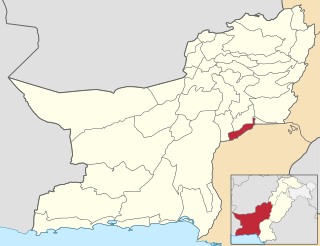
Jafarabad (Balochi: جعفر آباد, Urdu: ضلع جعفر آباد, district lies in southeast of the Pakistani province of Balochistan. Jafarabad's headquarters are at Dera Allah Yar, also known as Jhatpat among locals. Jaffarabad District is sub-divided into two tehsils. Recently in 2022 part of it was split off to form the new district of Usta Muhammad.
Ullum is a department of the Argentinean province of San Juan. It is located in the center of the province and its landscape is dominated by mountains and low vegetation. Its seat is Villa Ibáñez. It is also characterized by the production of grapes and fruit. The San Juan River is dammed by the Ullum Dam.
Ramblones is a village and municipality in Catamarca Province in northwestern Argentina.
Corcovado (Chubut) is a village and municipality in Chubut Province in southern Argentina.
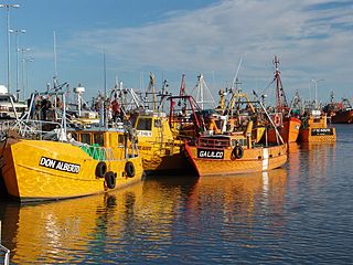
Puerto Rawson is a fishing port, village and municipality in Chubut Province in southern Argentina. It is located at the mouth of the Chubut River, about 5 km from the city of Rawson.

Villa Dique Florentino Ameghino is a rural commune in Chubut Province in southern Argentina. It is located next to the Florentino Ameghino Dam on the Chubut River, 140 kilometres (87 mi) to the west of the city of Trelew. The town had 224 residents as of the 2001 census, an 18.5% increase from the previous (1991) census, when it had 189 residents.
On the continent of Antarctica, the Aramis Range is the third range south in the Prince Charles Mountains, situated 11 miles southeast of the Porthos Range and extending for about 30 miles in a southwest–northeast direction. It was first visited in January 1957 by Australian National Antarctic Research Expeditions (ANARE) southern party led by W.G. Bewsher, who named it for a character in Alexandre Dumas' novel The Three Musketeers, the most popular book read on the southern journey.

The borders of the oceans are the limits of Earth's oceanic waters. The definition and number of oceans can vary depending on the adopted criteria. The principal divisions of the five oceans are the Pacific Ocean, Atlantic Ocean, Indian Ocean, Southern (Antarctic) Ocean, and Arctic Ocean. Smaller regions of the oceans are called seas, gulfs, bays, straits, and other terms. Geologically, an ocean is an area of oceanic crust covered by water.

Blériot Glacier is a short, but wide, glacier lying east of Salvesen Cove and Zimzelen Glacier and southwest of Cayley Glacier on Danco Coast, Graham Land in Antarctica. Photographed by the Falkland Islands and Dependencies Aerial Survey Expedition in 1956–57, and mapped from these photos by the Falkland Islands Dependencies Survey, it was named by the UK Antarctic Place-Names Committee in 1960 for Louis Blériot (1872–1936), a French aviator who in 1907 flew the first full-size powered monoplane, and who made the first flight across the English Channel in July 1909.
Coulston Glacier is a small tributary glacier flowing south from the Cartographers Range into Trafalgar Glacier, 10 nautical miles (19 km) west of Bypass Hill, in the Victory Mountains of Victoria Land. It was mapped by the United States Geological Survey from surveys and from U.S. Navy air photos 1960–64, and named by the Advisory Committee on Antarctic Names for Peter W. Coulston, an aviation electronics technician with U.S. Navy Squadron VX-6 at McMurdo Station, 1967.
Sirocco Glacier is a glacier about 3 nautical miles (6 km) long flowing north-northeast into West Bay, Fallières Coast, between Brindle Cliffs and Mount Edgell. Named by the United Kingdom Antarctic Place-Names Committee (UK-APC) in 1977 after the sirocco, the Italian name for the wind that blows from the Sahara. One of several features in the area named after winds.

The Richter Glacier is a low gradient coastal glacier located 18 km (11 mi) west of the Scott Nunataks on the northern side of Edward VII Peninsula. The feature saddles with the Butler Glacier and flows north-west to the sea where it forms a small tongue. The glacier and tongue are depicted on the map of the Byrd Antarctic Expedition, 1928–30. The map indicates that the landing party from the Kainan Maru (Shirase) traversed up this glacier to the summit of the Scott Nunataks in January 1912. The glacier was mapped in detail by the United States Geological Survey (USGS) from ground surveys and US Navy aerial photographs, 1959–65. It was named by the Advisory Committee on Antarctic Names (US-ACAN) for Gregory S. Richter, meteorologist-in-charge and scientific leader of the Byrd Station winter party in 1968.
Los Altares Valley, also called Las Ruinas Valley is a valley in central Chubut Province in southern Argentina. It is accessed via National Route 25.