
The Prince Charles Mountains are a major group of mountains in Mac. Robertson Land in Antarctica, including the Athos Range, the Porthos Range, and the Aramis Range. The highest peak is Mount Menzies, with a height of 3,228 m (10,591 ft). Other prominent peaks are Mount Izabelle and Mount Stinear. These mountains, together with other scattered peaks, form an arc about 420 km (260 mi) long, extending from the vicinity of Mount Starlight in the north to Goodspeed Nunataks in the south.
The Estuary of Bilbao lies at the common mouth of the rivers Nervion, Ibaizabal and Cadagua, which drain most of Biscay and part of Alava in the Basque Country, Spain. In this instance, the Spanish word estuario is used to describe what in English would normally be called part estuary, part tidal river. The estuary becomes a tidal river which extends 16 km (9.9 mi) into the city of Bilbao, starting from the Bilbao Abra bay. It hosts the port of Bilbao throughout its length, although the Port Authority has recently restored most of the upper reaches to Bilbao and other municipalities for their urban regeneration. The port is now being transferred to the seaboard on the coast at Santurtzi and Zierbena.
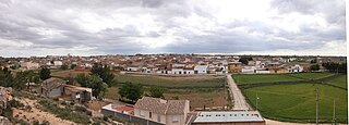
Ledaña is a municipality in Cuenca, Castile-La Mancha, Spain. It has a population of 1,882.

Navares de Ayuso is a municipality located in the province of Segovia, Castile and León, Spain. According to the 2004 census (INE), the municipality has a population of 73 inhabitants.
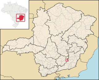
Cipotânea is a Brazilian municipality located in the state of Minas Gerais. The city belongs to the mesoregion of Zona da Mata and to the microregion of Viçosa. Its area is 153.435 km². As of 2020, the estimated population was 6,799.
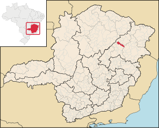
Chapada do Norte is a municipality in the northeast of the Brazilian state of Minas Gerais. As of 2020 the population was 15,345 in a total area of 828 km². The elevation of the town center is 751 meters. It is part of the IBGE statistical meso-region of Jequitinhonha and the micro-region of Capelinha. It became a municipality in 1963.

Felício dos Santos is a Brazilian municipality located in the center-north of the state of Minas Gerais. Its population as of 2020 was 4,704 living in a total area of 358 km². The city belongs to the statistical mesoregion of Jequitinhonha and to the statistical microregion of Diamantina. It became a municipality in 1953.
The Kugaryuak River is located in the Canadian Arctic territory of Nunavut in the southwest Kitikmeot Region. It forks into two entities, the Western Kugaryuak and the Eastern Kugaryuak and flows into Coronation Gulf.
São Domingos do Maranhão is a municipality in the state of Maranhão in the Northeast region of Brazil.
Huehuetlán el Chico (municipality) is a town and municipality in the state of Puebla in south-eastern Mexico.
La Carrera (Catamarca) is a municipality in Catamarca Province in northwestern Argentina. It is located within the Greater San Fernando del Valle de Catamarca area.
On the continent of Antarctica, the Aramis Range is the third range south in the Prince Charles Mountains, situated 11 miles southeast of the Porthos Range and extending for about 30 miles in a southwest–northeast direction. It was first visited in January 1957 by Australian National Antarctic Research Expeditions (ANARE) southern party led by W.G. Bewsher, who named it for a character in Alexandre Dumas' novel The Three Musketeers, the most popular book read on the southern journey.

Cole Channel is a marine channel running north–south between Wright Peninsula, Adelaide Island, and Wyatt Island, Laubeuf Fjord, off the Loubet Coast, Antarctica. It was named by the UK Antarctic Place-Names Committee in 1984 after Captain Maurice John Cole, Senior Master of the British Antarctic Survey ship Bransfield from 1975. Cole did previous Antarctic service as an officer on the John Biscoe and the Shackleton, for several seasons between 1960 and 1972.
Naess Glacier is a small glacier, which is separated from Chapman Glacier to the north by a rocky ridge, flowing from the west coast of Palmer Land into George VI Sound. First surveyed in 1936 by the British Graham Land Expedition (BGLE) under Rymill. Named by the United Kingdom Antarctic Place-Names Committee (UK-APC) in 1954 for Erling D. Naess, Mgr. of the Vestfold Whaling Co., who was of great assistance to the BGLE, 1934–37.
Nemo Glacier is a glacier flowing east into Nemo Cove, Pourquoi Pas Island, in northeast Marguerite Bay. Named by United Kingdom Antarctic Place-Names Committee (UK-APC), 1979, in association with Nemo Cove.

Demorest Glacier is a glacier on the northeast side of Hemimont Plateau which flows southeast into Whirlwind Inlet between Flint Glacier and Matthes Glacier, on the east coast of Graham Land. It was discovered by Sir Hubert Wilkins on a flight of December 20, 1928, and photographed from the air by the United States Antarctic Service in 1940. It was charted by the Falkland Islands Dependencies Survey in 1947 and named for Max H. Demorest, an American glaciologist.
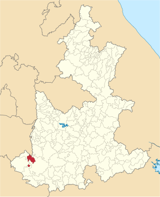
Castrillo-Tejeriego is a village in Valladolid, Castile-Leon, Spain. The municipality covers an area of 35.98 square kilometres (13.89 sq mi) and as of 2011 had a population of 203 people.
La Plaza is a Chilean village located in Pichilemu, Cardenal Caro Province.