The Elbe Cycle Route (Elberadweg in German) is part of an international network of cycling routes all over Europe. It is integrated in the system of currently 37 river cycling routes in Germany and by far the most popular route for cyclists in this country.
The Elbe Cycle Route starts in Špindlerův Mlýn in the Giant Mountains. It then runs for about 1220 km until it ends in Cuxhaven at the North Sea. Part of it falls together with the EV7 of the EuroVelo network. One variety of the route starts in Prague, following the river Vltava to the Elbe.
There are many small villages with old churches and other interesting sites along the way. A lot of restaurants and pensions offer their service to the weary after a day of cycling.
One of the other reasons however for its popularity is probably the fact that there are no significant level changes from Dresden on. It is practically downhill all the way from Dresden to Cuxhaven while the other direction mostly offers slight tailwinds.
The Elbe Cycling Route is marked throughout Germany with a special sign.
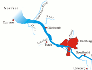
The Elbe is one of the major rivers of Central Europe. It rises in the Giant Mountains of the northern Czech Republic before traversing much of Bohemia, then Germany and flowing into the North Sea at Cuxhaven, 110 kilometres northwest of Hamburg. Its total length is 1,094 km (680 mi).
Herzogtum Lauenburg is the southernmost Kreis, or district, officially called Kreis Herzogtum Lauenburg, of Schleswig-Holstein, Germany. It is bordered by the district of Stormarn, the city of Lübeck, the state of Mecklenburg-Vorpommern, the state of Lower Saxony, and the city state of Hamburg. The district of Herzogtum Lauenburg is named after the former Duchy of Saxe-Lauenburg.
The Elbe–Lübeck Canal is an artificial waterway in eastern Schleswig-Holstein, Germany. It connects the rivers Elbe and Trave, creating an inland water route across the drainage divide from the North Sea to the Baltic Sea. The canal includes seven locks and runs for a length of 64 kilometres (40 mi) between the cities of Lübeck in the north and Lauenburg in the south by way of the Mölln lakes. The modern canal was built in the 1890s to replace the Stecknitz Canal, a medieval watercourse linking the same two rivers.
Cuxhaven is a district (Landkreis) in Lower Saxony, Germany. It is bounded by the districts of Stade, Rotenburg, Osterholz and Wesermarsch, the city of Bremerhaven and the North Sea.
Stade is a district (Landkreis) in Lower Saxony, Germany. It has its seat in Stade and is part of the Hamburg Metropolitan Region.
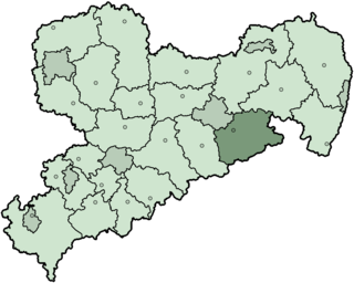
The Sächsische Schweiz is a former district (Kreis) in the south of Saxony, Germany. Neighboring districts were Weißeritzkreis, the district-free city Dresden and the districts Kamenz and Bautzen. To the south it borders the Czech Republic.
Saxon Switzerland is a hilly climbing area and national park in the Elbe Sandstone Mountains. It is located around the Elbe valley south-east of Dresden in Saxony, Germany, adjoining Bohemian Switzerland in the Czech Republic. Together with the Czech part, the region is known as Saxon-Bohemian Switzerland.
The Elbe Sandstone Mountains, also called the Elbe Sandstone Highlands, are a mountain range straddling the border between the state of Saxony in southeastern Germany and the North Bohemian region of the Czech Republic, with about three-quarters of the area lying on the German side. In both countries, core parts of the mountain range have been declared a national park. The name derives from the sandstone which was carved by erosion. The river Elbe breaks through the mountain range in a steep and narrow valley.
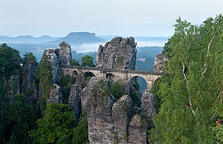
The Bastei is a rock formation rising 194 metres (636 ft) above the Elbe River in the Elbe Sandstone Mountains of Germany. Reaching a height of 305 metres (1,001 ft) above sea level, the jagged rocks of the Bastei were formed by water erosion over one million years ago. They are situated near Rathen, not far from Pirna southeast of the city of Dresden, and are the major landmark of the Saxon Switzerland National Park. They are also part of a climbing and hiking area that extends over the borders into the Bohemian Switzerland.
The 140-kilometre-long road, the Silver Road is the first and longest holiday route in the German Free State of Saxony. Against the background of the importance of mining in the history of Saxony, the road links those sights and tourist attractions of the Ore Mountains and its foreland that relate to the centuries-old mining and smelting industries of the region.
Saxon Switzerland National Park, is a national park in the German Free State of Saxony, near the Saxon capital Dresden. It covers two areas of 93.5 km2 (36.1 mi2) in the heart of the German part of the Elbe Sandstone Mountains, which is often called (the) Saxon Switzerland.
Dresden is a major German city and capital of Saxony. It is a road, train and air transport hub in eastern Germany. Local and commuter transport services grant accessibility in the Dresden agglomeration. The city has a dense network of tram and bus lines. Dresden has two major train stations, an international airport and an inner harbour on the Elbe river waterway. Autobahns grant access to all cardinal directions. Dresden is the junction of two class-A European routes.
The E1 European long-distance path, or just E1 path, is one of the European long-distance paths designated by the European Ramblers' Association. It has a total length of some 7,000 kilometres (4,300 mi). It begins in Norway at Nordkapp, and crosses the Kattegat between Sweden and Denmark by ferry. It passes through Denmark, Germany, and Switzerland to finish at Scapoli, Italy. This path was extended southwards to Sicily, in Italy in 2018.
Saxon Switzerland-Eastern Ore Mountains is a district (Kreis) in Saxony, Germany. It is named after the mountain ranges Saxon Switzerland and Eastern Ore Mountains.
The region between the Elbe and Weser rivers forms the Elbe–Weser triangle, also rendered Elbe-Weser Triangle, in northern Germany. It is also colloquially referred to as the Nasses Dreieck or "wet triangle".
The Kulmer Steig is a synonym for the transport links from the Elbe valley over the eastern part of the Eastern Ore Mountains to Bohemian Chlumec u Chabařovic, hence the name which means "Kulm Trail". It is an ancient road system of partly derelict and unmetalled historic transport routes. These historic long-distance routes have been uncovered today thanks to archaeological discoveries. The routes all head south from the Elbe valley between Dresden and Pirna and cross the Eastern Ore Mountains over mountain passes on the Saxon side between Fürstenwalde in the west and Oelsen in the east. The lowest crossings are located near Mohelnice from where they continue via Habartice and the Geiersberg as well as Krasný Les and further on over the Nollendorf Pass to Chlumec. The Kulmer Steig was an especially good transport route because the road cut a passage through untamed wilderness and 30 kilometres could be covered in a day.
The Unterelbe or, in English usually the Lower Elbe, refers to the lower reaches of the river Elbe in Germany influenced by the tides.
EuroVelo 7 (EV7), named the Sun Route, is a 7,409 km (4,604 mi) long EuroVelo long-distance cycling route running north–south through the whole of Europe from the North Cape in Norway to the island of Malta in the Mediterranean Sea. The route passes through nine countries, and from north to south these are: Norway, Finland, Sweden, Denmark, Germany, Czech Republic, Austria, Italy, Malta.
EuroVelo 5 (EV5), named the Via Romea Francigena, is a 3,900 km (2,400 mi) long EuroVelo long-distance cycling route running from Canterbury to Rome and ending at the Italian port of Brindisi. The route crosses Europe passing successively through six countries: UK, France, Belgium, Luxembourg, France again, Switzerland and Italy.
The Neu Darchau to Darchau ferry is a ferry route across the Elbe river in Germany. It crosses between the town of Neu Darchau, in the district of Lüchow-Dannenberg, and Darchau, in the municipality of Amt Neuhaus and district of Lüneburg. Both terminals are in the state of Lower Saxony, about 80 kilometres (50 mi) southeast of the city of Hamburg.
This page is based on this Wikipedia article Text is available under the CC BY-SA 4.0 license; additional terms may apply. Images, videos and audio are available under their respective licenses.