Maryborough may refer to:
Wellington North was a federal electoral district represented in the House of Commons of Canada from 1867 to 1953. It was located in the province of Ontario.
Wellington—Huron was a federal electoral district represented in the House of Commons of Canada from 1953 to 1968. It was located in the province of Ontario. This riding was created in 1952 from parts of Huron North, Wellington North and Wellington South ridings.
Wellington—Grey, renamed Wellington—Grey—Dufferin—Waterloo in 1970, was a federal electoral district represented in the House of Commons of Canada from 1968 to 1979. It was located in the province of Ontario. This riding was created in 1966 from parts of Dufferin—Simcoe, Grey—Bruce, Waterloo North, Wellington South and Wellington—Huron ridings.
Wellington—Dufferin—Simcoe was a federal electoral district represented in the House of Commons of Canada from 1979 to 1988. It was located in the province of Ontario. This riding was created in 1976 as Dufferin—Wellington and renamed in 1977. It was created from parts of Halton, Peel—Dufferin—Simcoe and Wellington—Grey—Dufferin—Waterloo ridings.
Perth—Wellington—Waterloo was a federal electoral district represented in the House of Commons of Canada from 1988 to 1997. It was located in the province of Ontario. This riding was created in 1987 from parts of Perth, Waterloo and Wellington—Dufferin—Simcoe ridings.
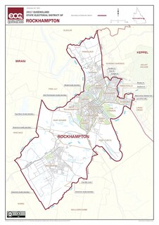
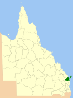
Rockhampton is an electoral district of the Legislative Assembly in the Australian state of Queensland.
The Fraser Coast Region is a local government area in the Wide Bay–Burnett region of Queensland, Australia, about 250 kilometres (160 mi) north of Brisbane, the state capital. It is centred on the twin cities of Hervey Bay and Maryborough, and also contains Fraser Island. It was created in 2008 from a merger of the Cities of Maryborough and Hervey Bay and the Shires of Woocoo and most of Tiaro. In June 2018 it had a population of 105,463.

Ripon is a single member electoral district of the Victorian Legislative Assembly. It is a rural electorate based in western Victoria. In 1946 the Electoral district of Ripon was first contested but then abolished in the 1955 election after being held by Labor for seven of these years. Ripon was re-created in 1976, essentially as a replacement for Hampden.
The Electoral district of Daylesford was an electoral district of the Victorian Legislative Assembly. It included the town of Daylesford, around 155 km north-west of Melbourne.
The Electoral district of Maryborough and Daylesford was an electoral district of the Victorian Legislative Assembly. It included the towns of Maryborough and Daylesford, around 168 km and 155 km north-west of Melbourne respectively.
The Electoral district of Maryborough and Talbot was an electorate of the Victorian Legislative Assembly from 1877.

The Electoral district of Maryborough was an electorate of the Victorian Legislative Assembly based on an area around Maryborough, Victoria. It was created in the expansion of the Assembly by the Victorian Electoral Act, 1858, which took effect at the election in 1859.
This is a list of electoral results for the electoral district of Maryborough in Queensland state elections.
Isis was an electoral district of the Legislative Assembly in the Australian state of Queensland, from 1932 until 1992. It was named after the Shire of Isis in the Wide Bay–Burnett region.
Wide Bay was a Legislative Assembly electorate in the state of Queensland.

Talbot was an electoral district of the Legislative Assembly in the Australian colony of Victoria from 1856 to 1859. It was based in western Victoria, bounded on the west by Bet Bet Creek, the north by the Loddon River, on the east by the Coliban River and included the area around the towns of Creswick, Daylesford and Carisbrook.
Kara Kara was an electoral district of the Legislative Assembly in the Australian state of Victoria from 1877 to 1927 and 1955 to 1976. It was based in north-western Victoria and included the subdivisions of Donald, Charlton, Minyip, Murtoa, St. Arnaud, Wedderburn, Inglewood, Dunnolly, Landsborough, Avoca, Maryborough and Carisbrook.
Burrum was a Legislative Assembly electorate in the state of Queensland, Australia.
The electoral district of Mount Morgan was a Legislative Assembly electorate in the state of Queensland, Australia, centred on the town of Mount Morgan.
This page is based on this
Wikipedia article Text is available under the
CC BY-SA 4.0 license; additional terms may apply.
Images, videos and audio are available under their respective licenses.