
The Tasmanian Legislative Council is the upper house of the Parliament of Tasmania in Australia. It is one of the two chambers of the Parliament, the other being the House of Assembly. Both houses sit in Parliament House in the state capital, Hobart. Members of the Legislative Council are often referred to as MLCs.

The electoral division of Windermere is one of the 15 electorates or 'seats' in the Tasmanian Legislative Council. The division is located on the East side of the Tamar River. It is named after the town of Windermere which is located along the banks of the river between Launceston and George Town.

The electoral division of Rosevears is one of the 15 electorates or 'seats' in the Tasmanian upper house. The division is located on the west side of the Tamar River. It is named after the town of Rosevears which is located on the river banks near Exeter.

The electoral division of Paterson was one of the 15 electorates or 'seats' in the Tasmanian Legislative Council from 1999 to 2008 when a redistribution saw it reverted to its original name of Launceston.
Gregory Raymond Hall is a former independent member of the Tasmanian Legislative Council in the McIntyre. He was also Mayor of the Meander Valley Council from 1997 to 2002. Hall was born in Launceston. He became a member of the Legislative Council at the 2001 Rowallan elections, defeating Russel Anderson.

The electoral district of Pilbara is a Legislative Assembly electorate in the state of Western Australia. Pilbara is named for the region of Western Australia in which it is located. It is one of the oldest electorates in Western Australia, with its first member having been elected to the Second Parliament of the Legislative Assembly at the 1894 elections.

The electoral district of Perth is a Legislative Assembly electorate in the state of Western Australia. Perth is named for the capital city of Western Australia whose central business district falls within its borders. It is one of the oldest electorates in Western Australia, with its first member having been elected in the inaugural 1890 elections of the Legislative Assembly.
Mitchell was an electoral district of the Legislative Assembly in the Australian state of Western Australia. It existed from 1983 to 2005 and, under the name Leschenault, continued until 2008.

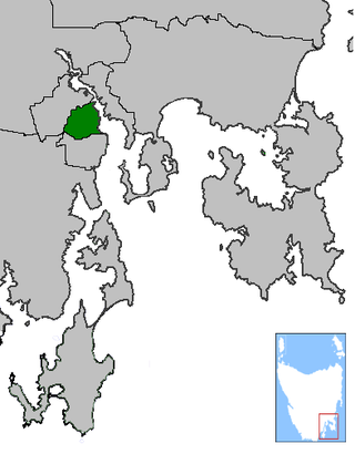
The electoral division of Murchison is one of the fifteen electorates in the Tasmanian Legislative Council, situated in the western/north-west region of the state. It is the largest electorate in size, covering an area of 19,391 km² and includes the municipalities of Circular Head, King Island, Waratah-Wynyard, West Coast and part of Burnie City.

The Tasmanian Legislative Council has fifteen single member constituencies, called divisions.
The Electoral division of Wellington was one of the 15 electorates or seats in the Tasmanian Legislative Council from 1999 to 2008. It covered the Hobart suburbs of Battery Point, New Town, West Hobart, Moonah, Mount Stuart, Lutana and Lenah Valley. The name was derived from Mount Wellington which is a dominant feature of the area.

The electoral division of Launceston is one of 15 electorates or seats in the Tasmanian Legislative Council, created in 2008. It also previously existed until 1999, when it was abolished and substantially incorporated into the new division of Paterson, which was in turn abolished in 2008.

The Division of Durack is an Australian Electoral Division in the state of Western Australia.
The electoral division of Western Tiers was an electorate of the Tasmanian Legislative Council, the division was abolished in 2017. The seat was created in 2008 after a redistribution saw the former Rowallan renamed after the Great Western Tiers mountain range in Tasmania's central highlands.
Periodic elections for the Tasmanian Legislative Council were held on 5 May 2012. The two seats up for election were Hobart, held by retiring Labor MLC Doug Parkinson, and Western Tiers, held by independent MLC Greg Hall. These seats were last contested in 2006.
Periodic elections for the Tasmanian Legislative Council were held on 6 May 2006. The two seats up for election were Rowallan, held by independent MLC Greg Hall, and Wellington, held by Labor MLC Doug Parkinson. Rowallan was last contested in 2001, while Wellington was last contested in 2000.
This is a list of members of the Tasmanian Legislative Council between 2017 and 2023. Terms of the Legislative Council did not coincide with Legislative Assembly elections, and members served six year terms, with a number of members facing election each year.

The electoral division of McIntyre is one of the fifteen electorates in the Tasmanian Legislative Council, it includes Flinders Island, the northern east coast of Tasmania, and regional areas south and west of Launceston. It is named after Margaret McIntyre, who was the first woman to be elected into the Parliament of Tasmania in 1948.

The electoral division of Prosser is one of the fifteen electorates in the Tasmanian Legislative Council, it includes the south-east coast of Tasmania, the Sorell township and the Tasman Peninsula. Prosser is named after the Prosser River, which flows through the centre of the division.
Periodic elections for the Tasmanian Legislative Council were held on 5 May 2018. The two seats up for elections were Hobart and Prosser. Hobart was previously contested in 2012. Prosser was a new division created in the 2017 redistribution, and was vacant pending this election.
