
The Electric Brae is a gravity hill in South Ayrshire, Scotland, where a freewheeling vehicle will appear to be drawn uphill by some mysterious attraction. The phenomenon is an optical illusion.
The Electric Brae is a gravity hill in South Ayrshire, Scotland, where a freewheeling vehicle will appear to be drawn uphill by some mysterious attraction. The phenomenon is an optical illusion.
The term "Electric" dates from a time when it was incorrectly thought to be a phenomenon caused by electric or magnetic attraction within the Brae. The Lowland Scots word brae means a hill-slope or brow (with which it is cognate). The name has also been applied to other slopes in Scotland.
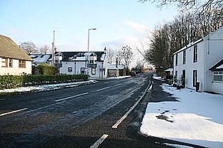
There is more than one stretch of road known as the Electric Brae. The most famous is on the A719, south of Dunure, not far from Ayr, between Drumshrang and Knoweside. [1] Metal road signs that used to mark the location have tended to be taken by visitors, and have been replaced by a stone inscribed with an explanation of the phenomenon. [lower-alpha 1]
Although the road appears to be running uphill, a suitably free-running vehicle will slowly move off from a standstill. It was widely believed that vehicles were being propelled uphill by a mysterious magnetic force, but the road's apparently uphill slope is an optical illusion. [1] This runs the quarter of a mile from the bend overlooking Croy railway viaduct in the west (286 feet Above Ordnance Datum) to the wooded Craigencroy Glen (303 feet A.O.D.) to the east. Whilst there is this slope of 1 in 86 upwards from the bend to the Glen, the configuration of the land on either side of the road provides an optical illusion making it look as if the slope is going the other way. Therefore, a stationary car on the road with the brakes off will appear to move slowly uphill.
There are hundreds of gravity hills around the world. The explanation often given for the phenomenon is that of a visual illusion, similar to the well-known Ames room, in which balls can appear to roll against gravity.
During the Second World War General Dwight D Eisenhower had a flat at nearby Culzean Castle. Eisenhower took visitors to see the phenomenon. Many other American personnel from the air-base at Prestwick also visited.

The Oregon Vortex is a roadside attraction that opened to tourists in 1930, located on Sardine Creek in Gold Hill, Oregon, in the United States. It consists of a number of interesting effects, which are gravity hill optical illusions, but which the attraction's proprietors propose are the result of paranormal properties of the area.

The Magnetic Hill is an example of a gravity hill, a type of optical illusion created by rising and descending terrain. It is located at the northwestern edge of the city of Moncton in the Canadian province of New Brunswick.
A gravity hill, also known as a magnetic hill, mystery hill, mystery spot, gravity road, or anti-gravity hill, is a place where the layout of the surrounding land produces an optical illusion, making a slight downhill slope appear to be an uphill slope. Thus, a car left out of gear will appear to be rolling uphill against gravity. Hundreds of gravity hills are recognized worldwide.
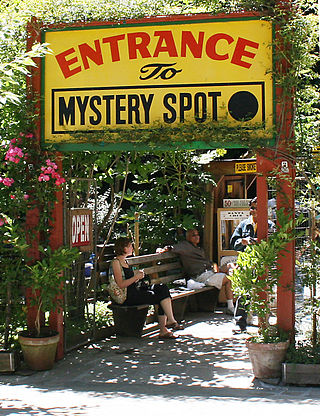
The Mystery Spot is a tourist attraction near Santa Cruz, California, opened in 1939 by George Prather. Visitors experience demonstrations that appear to defy gravity, on the short but steep uphill walk and inside a wooden building on the site. The Mystery Spot is a popular tourist attraction, and gained recognition as a roadside "gravity box" or "tilted house". The site is what is known as a gravity hill and was the first of its kind to be built in California.

An Ames room is a distorted room that creates an optical illusion. Likely influenced by the writings of Hermann Helmholtz, it was invented by American scientist Adelbert Ames Jr. in 1946, and constructed in the following year.
Gleniffer Braes is a short range of hills and park area to the south of Paisley, Scotland which form the boundary of Renfrewshire and North Ayrshire.

Spook Hill is a gravity hill, an optical illusion in Lake Wales, Florida, where cars appear to roll up the spooky hill.
Pandariya is a town and nagar panchayat and development block in Kabirdham district in the Indian state of Chhattisgarh. This block is famous for the Dewanpatpar magnetic hill, 40 km north of Pandariya, which has an optical illusion of a gravity hill where vehicle seems to defy the gravity and roll up the hill.

Electric Brae: A Modern Romance was the first novel by Scottish writer Andrew Greig. The title is a reference to Electric Brae in South Ayrshire, where a natural optical illusion makes it seem that things can roll uphill.
Parel Vallei is an affluent suburb Cape Town and also of Somerset West in the Western Cape, South Africa. There is a high school, Parel Vallei High School.
The A719 is a local road in Ayrshire, Scotland, connecting Girvan and the Ayrshire coastline with Glasgow via Ayr and Galston. Among other locations it passes the Trump Turnberry golf resort and the hamlet of Moscow.

Dunure is a small village in the South Ayrshire area of Scotland about five miles from Ayr, Scotland. It is located on the coast of the Firth of Clyde, and is near to Maybole, south of Ayr.
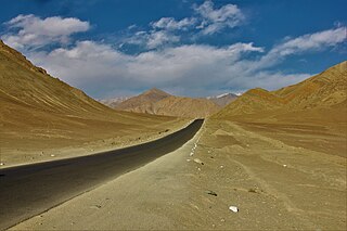
Magnet Hill is a gravity hill located near Leh in Ladakh, India. The layout of the area and surrounding slopes create the optical illusion of a hill. The hill road is actually a downhill road. Objects and cars on the hill road may appear to roll uphill in defiance of gravity when they are, in fact, rolling downhill. It is 7.5 km southeast of Nimmoo and 26.5 km west of Leh on Srinagar-Ladakh road.

Nimo or Nyemo is a village and the headquarters of an eponymous community development block in the Leh district of Ladakh, India. It is located in the Leh tehsil, 35 km from Leh.
Ronague is a tiny hamlet in the south of the Isle of Man, in the parish of Arbory. It consists of an old chapel, several houses and some farms. It lies to the north of the villages of Ballabeg and Colby, west of the hamlet of Grenaby and south of the hill South Barrule.

Kalo Dungar or Black Hill is the highest point in Kutch, Gujarat, India, at 462 m (1,516 ft). It is located 97 km (60 mi) from District headquarters of Bhuj and 25 km (16 mi) from nearest town Khavda.

Kimanis–Keningau Highway is a state highway in Sabah, Malaysia, connecting the town of Kimanis to Keningau. It also acts as an alternative for Federal Route 500 from Kota Kinabalu to Tenom which is nowadays somewhat under-use. The 53-kilometre (33 mi) highway began as a main logging road before being upgraded to a full two-lane highway. The highway was opened to traffic in 2006.
Mainpat is a hill station and small village in the Surguja district in the northern part of the state of Chhattisgarh, India. It lies about 55 kilometres (34 mi) by road from Ambikapur. This hill station is 50 km south of divisional headquarter of Ambikapur, 160 km northeast of Korba, and 360 km northeast of state capital Raipur.
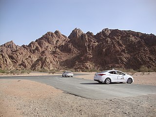
Wadi al-Baida, locally known as Wadi al-Jinn, is a valley and an anti-gravity hill in al-Baida Park located approximately 30 kilometers northwest of Medina in the Medina Province of Saudi Arabia. Owing to its optical illusion, vehicles left out of gear in the valley appear to be rolling uphill against the gravity, thus, making the area popular among locals and pilgrims to be purportedly haunted by Jinns, the shape-shifting supernatural creatures featured in both pre-Islamic Arabian folklores and Islamic beliefs. However, the Al Madinah Region Development Authority in 2020 rebutted claims of any spiritual presence in the valley.

Notes
The ELECTRIC BRAE, known locally as 'CROY BRAE'
Citations
Bibliography