Elijahs Creek is a stream in Boone County, Kentucky, United States. [1] It is a tributary of the Ohio River.
The namesake of Elijahs Creek is unknown. [2]
Elijahs Creek is a stream in Boone County, Kentucky, United States. [1] It is a tributary of the Ohio River.
The namesake of Elijahs Creek is unknown. [2]
Clark County is a county located in the U.S. state of Kentucky. As of the 2020 census, the population was 36,972. Its county seat is Winchester. The county was created in 1792 from Bourbon and Fayette counties and is named for Revolutionary War hero George Rogers Clark. Clark County is part of the Lexington-Fayette, KY Metropolitan Statistical Area.

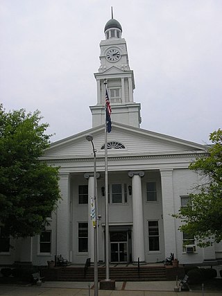
Boone County is a county located on the Ohio River in the northernmost part of the Commonwealth of Kentucky. As of the 2020 census, the population was 135,968, making it the fourth-most populous county in Kentucky. Its county seat is Burlington. The county was formed in 1798 from a portion of Campbell County and was named for frontiersman Daniel Boone. Boone County, with Kenton and Campbell Counties, is of the Northern Kentucky metro area, and the Cincinnati-Middletown, OH-KY-IN Metropolitan Statistical Area. It is the location of the Cincinnati/Northern Kentucky International Airport, which serves Cincinnati and the tri-state area.

Boonesborough or Boonesboro is an unincorporated community in Madison County, Kentucky, United States. Founded by famed frontiersman Daniel Boone in 1775 as one of the first English-speaking settlements west of the Appalachian Mountains, Boonesborough lies in the central part of the state along the Kentucky River and is the site of Fort Boonesborough State Park, which includes the Kentucky River Museum. The park site has been rebuilt to look like a working fort of the time that Boone resided there.

The Big South Fork of the Cumberland River is a 76-mile-long (122 km) river in the U.S. states of Tennessee and Kentucky. It is a major drainage feature of the Cumberland Plateau, a major tributary of the Cumberland River system, and the major feature of the Big South Fork National River and Recreation Area.

The Sheltowee Trace Trail is a 343-mile (552.00 km) National Recreation Trail that was created in 1979 and stretches from the Burnt Mill Bridge Trail Head in the Big South Fork National River and Recreation Area in Tennessee to northern Rowan County, Kentucky. The trail is named after Daniel Boone, who was given the name Sheltowee when he was adopted as the son of the great warrior Chief Blackfish of the Shawnee tribe.

Boone Station State Historic Site was a 46-acre (190,000 m2) Kentucky State Historic Site on Boone's Creek near Athens in Fayette County, Kentucky, USA.

Bryan Station was an early fortified settlement in Lexington, Kentucky. It was located on present-day Bryan Station Road, about three miles (5 km) northeast of New Circle Road, on the southern bank of Elkhorn Creek near Briar Hill Road. The settlement was established in the spring of 1776 by brothers Morgan, James, William, and Joseph Bryan, and brother-in-law William Grant, all from Yadkin River Valley, Rowan County, North Carolina. After a disastrous winter and attacks by Native Americans, all the Bryan family survivors abandoned the station and returned to the Yadkin River Valley in August 1780. Falling under the command of Elijah Craig, the remaining occupants withstood several American Indian attacks.

The Carroll Lee Cropper Bridge is a continuous steel arch-shaped truss bridge over the Ohio River between Indiana and Kentucky. Built between 1968 and 1977, the four-lane arched truss span provides a western Ohio River crossing for the Interstate 275 beltway around the Cincinnati area. The section of Interstate 275 on the Cropper bridge is the only Interstate highway in the Cincinnati, Ohio area that goes between Indiana and Kentucky.
Banklick Creek is a 19.1-mile-long (30.7 km) tributary of the Licking River in northern Kentucky in the United States. By the Licking River and the Ohio River, it is part of the Mississippi River watershed.

The Licking River is a partly navigable, 303-mile-long (488 km) tributary of the Ohio River in northeastern Kentucky. The river and its tributaries drain much of the region of northeastern Kentucky between the watersheds of the Kentucky River to the west and the Big Sandy River to the east. The North Fork Licking River, in Pendleton County, Kentucky, is one of its tributaries. The South Fork Licking River, in counties including Harrison County, Kentucky, is another.
Cruises Creek is a stream in Boone and Kenton counties, Kentucky, in the United States. It is a tributary of the Licking River.
Perche Township is one of ten townships in Boone County, Missouri, USA. As of the 2012, its population was 4,037. The village of Harrisburg is the only incorporated settlement inside the township.
Taylorsport is an unincorporated community in Boone County, Kentucky, in the United States.
Dreaming Creek is a stream in Madison County, Kentucky, in the United States.
Taylors Creek is a stream in Campbell County, Kentucky, in the United States. A variant name is Duck Creek. It is a tributary of the Ohio River. Taylors Creek forms the border between the towns of Bellevue, Kentucky and Newport, Kentucky.
Dry Creek is a stream in Boone and Kenton counties, Kentucky, in the United States. It is a tributary of the Ohio River.
Limaburg is an unincorporated community in Boone County, in the U.S. state of Kentucky.
Taylor Creek is a stream in Boone County, Kentucky, United States. It is a tributary of the Ohio River.
Woolper Creek is a stream in Boone County, Kentucky, United States. It is a tributary of the Ohio River.
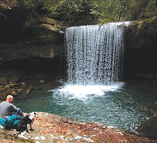
Dog Slaughter Falls is a 15 feet (4.6 m) to 20 feet (6.1 m) tall waterfall at the confluence of the Cumberland River and Dog Slaughter Creek, in the London Ranger District of the Daniel Boone National Forest in Whitley County, Kentucky. It is accessible via the Sheltowee Trace Trail, traveling downstream of Cumberland Falls, or via the Dog Slaughter Trail. The falls is rumored to be named for the drowning of unwanted pets, or the loss of hunting dogs to predatory wildlife.
39°06′11″N84°41′40″W / 39.1031144°N 84.6943911°W