Brunei is a country in Southeast Asia, bordering the South China Sea and East Malaysia. Its geographical coordinates are 4°30′N 114°40′E.

Montserrat is an island in the Caribbean Sea, in the Leeward Islands. Its nearest neighbours in the island chain include Guadeloupe to the south-east, Antigua to the north-east and Nevis to the north-west. The island is 16 km (9.9 mi) long and 11 km (6.8 mi) wide, with a coastline of about 40 km.

The geography of Malta is dominated by water. Malta is an archipelago of coralline limestone, located in the Mediterranean Sea, 81 kilometres south of Sicily, Italy, and nearly 300 km north (Libya) and northeast (Tunisia) of Africa. Although Malta is situated in Southern Europe, it is located farther south than Tunis, capital of Tunisia, Algiers, capital of Algeria, Tangier in Morocco and also Aleppo in Syria, and Mosul in Iraq in the Middle East. Only the three largest islands – Malta, Gozo and Comino – are inhabited. Other (uninhabited) islands are: Cominotto, Filfla and the St.Paul's Islands. The country is approximately 316 km2 in area. Numerous bays along the indented coastline of the islands provide harbours. The landscape of the islands is characterised by high hills with terraced fields. The highest point, at 253 metres, Ta' Zuta on mainland Malta. The capital is Valletta.

The Gambia is a very small and narrow country with the border based on the Gambia River. The country is less than 48 km wide at its greatest width. The country's present boundaries were defined in 1889 after an agreement between the United Kingdom and France. It is often claimed by Gambians that the distance of the borders from the Gambia River corresponds to the area that British naval cannon of the time could reach from the river's channel. However, there is no historical evidence to support the story, and the border was actually delineated using careful surveying methods by the Franco-British boundary commission. Apart from its coastline, where the Gambia borders the Atlantic Ocean, it is an enclave of Senegal and is by far the smallest country on mainland Africa.

North Fond du Lac is a village in Fond du Lac County, Wisconsin, United States. The population was 5,014 at the 2010 census. Despite the name, North Fond du Lac is actually located northwest of Fond du Lac, as Lake Winnebago is directly north of Fond du Lac.

Oregon is a village in Dane County, Wisconsin, United States. As of the census of 2010, the population was 9,231. Oregon is part of the Madison Metropolitan Statistical Area. The village is located mostly within the Town of Oregon.

The Boeing Business Jet series are variants of Boeing jet airliners for the corporate jet market.
Ghotki District is a district in Pakistan, located in the Sindh province. Its capital city is Ghotki City. Prior to its establishment as a district in 1983, it formed part of Sukkur District.
According to the 1998 census, the district had a population of 970,550. Of these residents, 158,500 (16.33%) lived in urban areas, and 812,050 (83.67%) lived in rural areas.

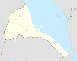
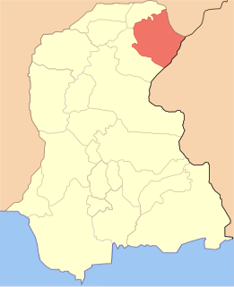
Barentu is a town in north-western Eritrea, lying south of Agordat, and is the capital of Gash-Barka Region. The town is integrated with different types of tribes: Kunama, Nara, Tigre and Tigrigna being the dominant.
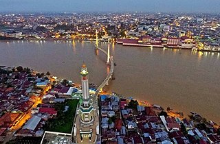
Jambi is the capital and largest city of the Indonesian province of Jambi. Located on the island of Sumatra, the city is a busy port on the Batang Hari River and an oil- and rubber-producing centre. The city is located 26 km (16 mi) from the ruins of Muaro Jambi, an important city in the ancient Srivijaya kingdom.
In aviation, the flight length is defined as the distance of a flight. Commercial flights are often categorized into long-, medium- or short-haul by commercial airlines based on flight length, although there is no international standard definition and many airlines use air time or geographic boundaries instead.
Route category lengths tend to define short-haul routes as being shorter than 600–800 nmi (1,100–1,500 km), long-haul as being longer than 2,200–2,600 nmi (4,100–4,800 km), and medium-haul as being in-between.

The Boeing Everett Factory, in Everett, Washington, is an airplane assembly building owned by Boeing. Located on the north-east corner of Paine Field, it is the largest building in the world by volume at 13,385,378 m3 and covers 399,480 m2. This is the factory where the wide-body Boeing 747, 767, 777, and 787 are assembled.

Ad Casub is a village in western Eritrea. It is located in Gogne District in the Gash-Barka region.
Adendema is a village in western Eritrea. It is located 5.8 miles south-west of the district capital of Haykota in Haykota District in the Gash-Barka region. It lies on the north-east boundary of the Gash-Setit wildlife reserve.
Sonoma Valley Airport is a public-use airstrip founded in 1946 by Wally Reichelt. Its first California certificated runway opened in August 1959.Sonoma, California, United States. Located 4.14 nmi (7.67 km) south of central district of Sonoma and 26.9 nmi (49.8 km) north of San Francisco, the airfield offers two asphalt runways, of which the 17/35 is restricted, needing prior permission to use. Please call the airport at 707-938-2444.
Open to public use for light aircraft, Sonoma Valley Airport does not allow ultralight and rotorcraft operations, except for MEDEVAC or law enforcement helicopters.

Cansado is a coastal town in north-western Mauritania on the Ras Nouadhibou peninsula. It is located in the Nouadhibou Department in the Dakhlet Nouadhibou region.

Amou is a village in western Benin. It is located in Savalou commune in the Collines Department. Prior to 1999 Amou was part of the former Zou Province.

German submarine U-575 was a Type VIIC U-boat in service of Nazi Germany's Kriegsmarine during World War II. She carried out ten patrols, sailing for 463 days and sinking eight ships totalling 36,010 gross register tons (GRT) and damaged three others of 29,777 GRT. She was a member of 18 separate wolfpacks and was sunk north of the Azores by Allied ships and aircraft on March 1944.