
The River Wharfe is a river in Yorkshire, England. For much of its length it is the county boundary between West Yorkshire and North Yorkshire.
Shelley is a village in the civil parish of Kirkburton in the county of West Yorkshire, England. The village is 3 miles (5 km) north of Holmfirth and 6 miles (10 km) southeast of Huddersfield.

The West Riding of Yorkshire is one of the three historic subdivisions of Yorkshire, England. From 1889 to 1974 the administrative county, County of York, West Riding, was based closely on the historic boundaries. The lieutenancy at that time included the City of York and as such was named West Riding of the County of York and the County of the City of York.

Wharfedale is one of the Yorkshire Dales. It is situated within the boroughs of Craven, and Harrogate in North Yorkshire, and the cities of Leeds, and Bradford in West Yorkshire. It is the upper valley of the River Wharfe. Towns and villages in Wharfedale include Buckden, Kettlewell, Conistone, Grassington, Hebden, Bolton Abbey, Addingham, Ilkley, Burley-in-Wharfedale, Otley, Pool-in-Wharfedale, Arthington, Collingham and Wetherby. Beyond Wetherby, the valley opens out and becomes part of the Vale of York.

Selby District is a local government district of North Yorkshire, England. The local authority, Selby District Council, is based in the town of Selby and provides services to an area which includes Tadcaster and a host of villages. The Local Authority had a population of 83,449 at the 2011 Census. It is the southern most district of North Yorkshire, and it borders the City of York, a unitary authority, the districts of the City of Leeds and the City of Wakefield, in West Yorkshire, the town of Doncaster, in South Yorkshire, the ceremonial county of the East Riding of Yorkshire, and the Borough of Harrogate.

The Borough of Harrogate is a local government district and borough of North Yorkshire, England. Its population at the census of 2011 was 157,869. Its council is based in the town of Harrogate, but it also includes surrounding towns and villages and almost all of the Nidderdale Area of Outstanding Natural Beauty. It is the most populous district of North Yorkshire. The district is part of the Leeds City Region. It borders the City of Leeds, and the City of Bradford, districts of West Yorkshire.

Hatfield is a town and civil parish in the Metropolitan Borough of Doncaster in South Yorkshire, England. It had a population of 16,776 at the 2011 Census, with its population split between the Hatfield and Thorne wards.

Haltemprice and Howden is a constituency in the East Riding of Yorkshire represented in the House of Commons of the UK Parliament since 1997 by David Davis, a Conservative who was also Secretary of State for Exiting the European Union until his resignation from that role on 8 July 2018.

Barnsdale, or Barnsdale Forest, is an area of South Yorkshire, England. The area falls within the Whitley Ward of the Wakefield Metropolitan Council. Barnsdale is historically part of the West Riding of Yorkshire. Barnsdale lies in the immediate vicinity north and north-west of Doncaster, and which was formerly forested and a place of royal hunts, and also renowned as a haunt of the outlaw Robin Hood in early ballads.

Nostell Miners Welfare Football Club is an English football club based in New Crofton, West Yorkshire. The club are currently members of the Northern Counties East League Division One.

Cutler Heights is a locality between Bowling and Laisterdyke in Bradford, West Yorkshire, England. It is known for its many industrial estates, among them engineering and steel trading businesses.

Thackley A.F.C. are a football club based in Thackley, north Bradford, West Yorkshire, England. The club plays in the Northern Counties East Football League Premier Division.

The Trough of Bowland is a valley and high pass in the Forest of Bowland Area of Outstanding Natural Beauty, Lancashire, England.

The Idle Working Men's Club is a working men's club in the village of Idle, a suburb of Bradford in West Yorkshire, England.
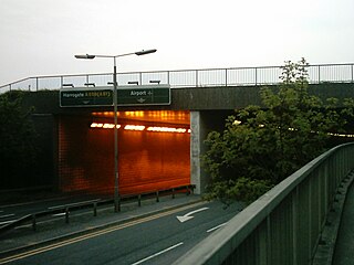
The A658 is a road in the UK running from Bradford, West Yorkshire (53.7949°N 1.7487°W), to Knaresborough, North Yorkshire (54.0065°N 1.4327°W), passing along the way Leeds Bradford International Airport, where it runs through a tunnel directly under the main runway. The road originally terminated south of the village of Pannal at the junction with the A61 but was extended when the south Harrogate and Knaresborough bypass was built and the road now ends east of Knaresborough where it meets the A59.

The Way of the Roses is the newest of Great Britain's coast-to-coast, long-distance cycle routes and is based on minor roads, disused railway lines and specially constructed cycle paths. It lies entirely within the counties of Lancashire and Yorkshire, crossing the Yorkshire Dales and the Yorkshire Wolds in the north of England, passing through the historic cities of Lancaster and York and scenic towns and villages including Settle, Pateley Bridge and Ripon.
National Cycle Network (NCN) Route 164 is a Sustrans regional route in the Yorkshire Wolds. The Northern section between Pocklington and Hutton Cranswick is part of the Way of the Roses, opened in 2010. The southern section links Beverley and Kiplingcotes via Newbold. Both sections are key parts of the 146 mile Yorkshire Wolds Cycle Route, opened in 2011. It is fully open and signed.

Tyersal Beck is a watercourse in West Yorkshire, England, named after the village of Tyersal in whose vicinity it runs.
Steeton Association Football Club is an English football club based in Steeton, West Yorkshire. They are currently members of the North West Counties League Division One North and play at Cougar Park.

Shelley Community Football Club is an English football club based in Shelley, West Yorkshire. They are currently members of the North West Counties League Division One North and play at Storthes Hall Park.


