Trinidad and Tobago, a country that relies heavily on industrialisation and tourism, has various transport systems.

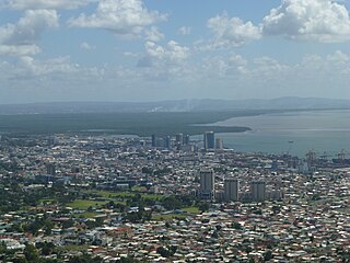
Port of Spain, officially the City of Port of Spain, is the capital of Trinidad and Tobago and the third largest municipality, after Chaguanas and San Fernando. The city has a municipal population of 37,074 (2011), an urban population of 81,142 and a transient daily population of 250,000. It is located on the Gulf of Paria, on the northwest coast of the island of Trinidad and is part of a larger conurbation stretching from Chaguaramas in the west to Arima in the east with an estimated population of 600,000.
The Jammat-al-Muslimeen is a radical extremist Islamist fundamentalist group in Trinidad and Tobago.

Scarborough is a major town of the Island of Tobago as well as the eleventh-most-populous in Trinidad and Tobago. Scarborough was the capital of Tobago in 1769 before it was unified with Trinidad changing the capital to Port of Spain. Situated in western Tobago, Scarborough is the economic and cultural centre of the island of Tobago. The estimated population in 2011 was 17,537. Scarborough is ranked as one of Trinidad and Tobago's most densely populated towns alongside Port of Spain, San Fernando, Chaguanas and Arima. The town's skyline is dominated by Fort King George, an 18th-century fortification named after King George III, which now hosts a historic and archaeologic museum. Scarborough's deepwater harbour was built in 1991; before that ships were forced to anchor offshore.

The Borough of Chaguanas is the largest municipality and fastest-growing town in Trinidad and Tobago. Located in west-central Trinidad, south of Port of Spain, north of Couva and San Fernando, and named after the indigenous tribe who originally settled there, it grew in size due to its proximity to the Woodford Lodge sugar refinery. It remained a minor town until the 1980s when it began to grow rapidly as it drew people for its bargain shopping and moderately priced housing. Its rapid growth has seen property values increase dramatically, however.

The Panyols are a pardo or moreno (tri-racial) ethnic group in Trinidad and Tobago of Afro-Spanish-Indigenous descent, primarily of mixed South American Amerindian, Trinidad and Tobago Amerindian, Afro-Trinidadian, Afro-Venezuelans and Spanish descent. The name is a derivation of the word 'español', as well as the community's settlement in what became predominantly cocoa cultivated regions of Trinidad. Also referred to as Pagnols or Payols, the panyol communities draw cultural influence from both sides of the Gulf of Paria, and are predominantly found within the Northern Range rainforest mountains and valleys of Trinidad, with South American cultural influences most predominantly derived from regions around the Orinoco, and Caura River, Venezuela.
Couva is an urban town in west-central Trinidad, south of Port of Spain and Chaguanas and north of San Fernando and Point Fortin. It is the capital and main urban centre of Couva–Tabaquite–Talparo, and the Greater Couva area includes the Point Lisas industrial estate and the port of Point Lisas. It is one of the fastest-growing towns in the country. Couva's southern boundary is at the village of California and Point Lisas, and to the north Couva stretches to McBean. To the east of Couva is Preysal. To the west of Couva is the road to Waterloo and Carli Bay, which are located on the Gulf of Paria. Couva was part of the Caroni County. Couva is considered a major power base for the United National Congress, whose headquarters was previously located here.

Diego Martin is a town and is the urban commercial center and capital of the Diego Martin region in Trinidad and Tobago. Its location in the region is just on the south eastern border, west of the capital city of Port of Spain and east of the town of Carenage. Diego Martin town in the Northern Range was once filled with a number of small valleys but is now a densely populated area. It was named after a Spanish explorer Don Diego Martín. The area was settled by French planters and their slaves in the 1780s. It consists of a cluster of communities including Congo Village, Diamond Vale, Green Hill, Patna Village, Petit Valley, Blue Range, La Puerta Avenue, Four Roads, Rich Plain, River Estate, Blue Basin, Water Wheel, West Moorings, Bagatelle and Sierra Leone.

Trinidad and Tobago, officially the Republic of Trinidad and Tobago, is the southernmost island country in the Caribbean. Consisting of the main islands Trinidad and Tobago and numerous much smaller islands, it is situated 11 kilometres off the coast of northeastern Venezuela and 130 kilometres south of Grenada. It shares maritime boundaries with Barbados to the east, Grenada to the northwest and Venezuela to the south and west. Trinidad and Tobago is generally considered to be part of the West Indies. The island country's capital is Port of Spain, while its largest and most populous municipality is Chaguanas.

Saint James is a district of Port of Spain, Trinidad and Tobago. Port of Spain's last major municipal expansion occurred in 1938, when the St. James district north of Woodbrook and west of St. Clair was incorporated into the city limits. In the late 19th century, Indian indentured labourers on nearby sugar estates established houses here, and St. James gradually became the centre of Port of Spain's Indian population, with many streets named after cities and districts in British India. Western Main Road, the area's major thoroughfare, has long been the city's main nightlife district, sometimes nicknamed "the city that never sleeps".

Morvant is a community in Trinidad and Tobago located east of Port of Spain and west of Barataria.
Radio Trinidad was the oldest radio station in Trinidad and Tobago. It began broadcasting in 1947 at 11B Maraval Road in Port of Spain on the frequency 730 AM.

Maraval is one of the northern suburbs of Trinidad's capital, Port of Spain, a valley in northern Trinidad in Trinidad and Tobago. It is situated at the bottom of the hills of Paramin and located east of the Diego Martin valley to which it is connected directly by Morne Coco Road, and west of Santa Cruz valley, to which it is connected by Saddle Road.
Patricia Rawlins Robinson was a Trinidadian economist and public servant who served as the First Lady of Trinidad and Tobago from 1997 until 2003. She was married to former President and Prime Minister A. N. R. Robinson.
Downtown Port of Spain is the central business district of Port of Spain, Trinidad and Tobago. The largest of the city's 7 commercial districts. The Downtown district of Port of Spain is also the oldest district of the city, between South Quay, Oxford Street, the St. Ann's River, and Richmond Street.

The Magnificent Seven is a group of seven mansions located west of the Queen's Park Savannah in northern Port of Spain, Trinidad and Tobago on Maraval Road in the St Clair neighborhood. They were built between 1902 and 1910 on land that was previously used as a government stock farm and are listed as heritage sites at the National Trust of Trinidad and Tobago. Stollmeyer's Castle was the first building in the neighborhood and took several years to complete, as was typical of the Magnificent Seven.

Belmont, in north-east Port of Spain, in the Republic of Trinidad and Tobago, is located at the foot of the Laventille Hills; it was the city's first suburb. In the 1840s–'50s, parts of the area were settled by Africans rescued by the Royal Navy from illegal slaving ships. In the 1880s–'90s, the population swelled rapidly, and the characteristic Belmont street pattern of narrow, winding lanes developed. The black professional class built large homes in Belmont, as they were excluded from the more expensive neighbourhoods such as St. Clair and Maraval; Belmont became known as "the Black St. Clair". Many of these large homes have been renovated and converted to business use, but some remain in family hands. Belmont currently is a lower-middle to middle-class residential neighbourhood. It was the birthplace and early home of many important Carnival designers and bandleaders. Belmont has 9,035 inhabitants.

Saint Clair is a business and residential district between the Queen's Park Savannah and the Maraval River in Port of Spain, Trinidad and Tobago. It is home to most of the city's grandest and largest mansions and also home to the Magnificent Seven Houses. Federation Park and Ellerslie Park. St Clair is one of Port of Spain's five police districts.
