This article needs additional citations for verification .(November 2024) |
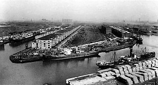
Ellesmere Port Dock is a dock in Britain, situated on the Manchester Ship Canal, in Ellesmere Port, Cheshire, England. [1]
This article needs additional citations for verification .(November 2024) |
Ellesmere Port Dock is a dock in Britain, situated on the Manchester Ship Canal, in Ellesmere Port, Cheshire, England. [1]
Ellesmere Canal is the name of the area were the canal joins the river Mersey; by the mid-1790s it was known as Ellesmere Port. Docks and warehouses were built to facilitate this.

Between 1830 and the 1840s facilities were improved by the engineer Thomas Telford and others. In 1846 the Ellesmere Canal was amalgamated with the Shropshire Union Canal.
In 1892 a new wharf was built to handle traffic on the Manchester Ship Canal.
In 1921 the docks were leased to the Manchester Ship Canal, and this led to the decline of Ellesmere Port.
The site is now the National Waterways Museum, Ellesmere Port (formerly known as the Boat Museum).
In 2007, as part of a revival of some industries, ports and shipbuilding in Britain, Ellesmere Port docks were re-opened. In 2008 the site of Ellesmere Port's operational dock - including over 70 acres (280,000 m2) of the waterfront area (immediately to the north-west of Ellesmere Port Historic Dock and Conservation Area and to the south-east of the Bridgewater Paper Works) - was the subject of a planning consultation, in which it may have been proposed that the docks be relocated closer to Eastham on the Cheshire West and Chester/Wirral boundary, and the area be redeveloped into a predominantly residential area consisting of up to 8,000 new homes. Plans for such development were expected to be submitted to the Local Authority during early 2009.[ citation needed ]

The River Mersey is a major river in North West England. Its name derives from Old English and means "boundary river", possibly referring to its having been a border between the ancient kingdoms of Mercia and Northumbria. For centuries it has formed part of the boundary between the historic counties of Lancashire and Cheshire.

The Manchester Ship Canal is a 36-mile-long (58 km) inland waterway in the North West of England linking Manchester to the Irish Sea. Starting at the Mersey Estuary at Eastham, near Ellesmere Port, Cheshire, it generally follows the original routes of the rivers Mersey and Irwell through the historic counties of Cheshire and Lancashire. Several sets of locks lift vessels about 60 ft (18 m) to the canal's terminus in Manchester. Landmarks along its route include the Barton Swing Aqueduct, the world's only swing aqueduct, and Trafford Park, the world's first planned industrial estate and still the largest in Europe.

Ellesmere Port is a port town in the Cheshire West and Chester borough in Cheshire, England. Ellesmere Port is on the south eastern edge of the Wirral Peninsula, six miles north of Chester, on the bank of the Manchester Ship Canal. The town had a population of 61,090 in the 2011 census. Ellesmere Port also forms part of the wider Birkenhead urban area, which had a population of 325,264 in 2011.

The Ellesmere Canal was a waterway in England and Wales that was planned to carry boat traffic between the rivers Mersey and Severn. The proposal would create a link between the Port of Liverpool and the mineral industries in north east Wales and the manufacturing centres in the West Midlands. However, the canal was never completed as intended because of its rising costs and failure to generate the expected commercial traffic.

The Shropshire Union Canal, sometimes nicknamed the "Shroppie", is a navigable canal in England. The Llangollen and Montgomery canals are the modern names of branches of the Shropshire Union (SU) system and lie partially in Wales.

Manchester docks were nine docks in Salford, Stretford and Manchester, at the eastern end of the Manchester Ship Canal in North West England, which formed part of the Port of Manchester from 1894 until their closure in 1982. They marked the upper reaches of the ship canal, and were a destination for both coastal and ocean-bound vessels carrying cargo and passengers, often travelling to and from Canada.

The Mersey Docks and Harbour Company (MDHC), formerly the Mersey Docks and Harbour Board (MDHB), owns and administers the dock facilities of the Port of Liverpool, on the River Mersey, England. These include the operation of the enclosed northern dock system that runs from Prince's Dock to Seaforth Dock, in the city of Liverpool and the dock facilities built around the Great Float of the Wirral Peninsula, located on the west side of the river.

Runcorn Docks, originally the Bridgewater Docks, is an inland port on the Manchester Ship Canal in the town of Runcorn, Cheshire, England. It is operated by Peel Ports and handles bulk and project cargo.

Queen Elizabeth II Dock is a dock situated on the River Mersey at Eastham, in the Metropolitan Borough of Wirral, Merseyside, England.

Weston Point Docks, also known as the Port of Weston, is an inland port on the Manchester Ship Canal in the town of Runcorn, Cheshire, England. It is operated by FLX Logistics.

The National Waterways Museum (NWM) is in Ellesmere Port, Cheshire, England, at the northern end of the Shropshire Union Canal where it meets the Manchester Ship Canal. The NWM's collections and archives focus on the Britain's navigable inland waterways, including its rivers and canals, and include canal boats, traditional clothing, painted canal decorative ware and tools. It is one of several museums and attractions operated by the Canal & River Trust, the successor to The Waterways Trust.

Warrington Bank Quay is one of three railway stations serving the town of Warrington in Cheshire, England. It is a principal stop on the West Coast Main Line between London Euston and Glasgow Central. The station is a north–south oriented main-line station on one side of the main shopping area, with the west–east oriented Warrington West and Warrington Central operating a more frequent service to the neighbouring cities of Liverpool and Manchester.

The Hooton–Helsby line is a railway line in the north-west of England that runs from Hooton on the Chester–Birkenhead line to the village and junction station at Helsby where it joins the Chester–Warrington line.

The Runcorn and Weston Canal was a short canal near Runcorn in Cheshire, England, constructed to link the Weston Canal, which is part of the River Weaver Navigation, to the Bridgewater Canal and Runcorn Docks. It was completed in 1859, but was little used. Around half of it became the Arnold Dock in 1876, when it was made wider and deeper, and linked to Fenton Dock by a ship lock. The dock section and some of the remaining canal were filled in during the 1960s, and the remainder is in a derelict state.

The Runcorn to Latchford Canal was a man-made canal that ran from Runcorn, to the Latchford area of Warrington. It connected the Mersey and Irwell Navigation to the River Mersey at Runcorn.

Port Salford is a freight terminal on the banks of the Manchester Ship Canal in Barton-upon-Irwell, Greater Manchester, England, 6 miles (9.7 km) west of Manchester city centre. The port is part of the Atlantic Gateway project and its construction was led by Peel Ports, a subsidiary of the Peel Group, and was opened in 2016.

Mount Manisty is a large uninhabited man-made hillock located between the Manchester Ship Canal and the River Mersey 1.5 miles (2.4 km) northwest of Ellesmere Port in Cheshire, England. The mound, which is 100 feet (30 m) tall, was created from earth excavated during the building of the ship canal between Eastham and Ellesmere Port in the late 19th century. The feature forms a narrow elevated stretch of land between the canal and the river.

Westminster is a suburb of the town of Ellesmere Port, Cheshire, England. It is a ward of the unitary authority of Cheshire West and Chester. Located to the north of the town centre, Westminster consists of largely early 20th century terraced housing towards the Manchester Ship Canal and post-war properties further inland. The Joseph Groome Towers are three thirteen-storey tower blocks built as public housing in the 1960s.
Daresbury was a Mersey flat that is now in a ruinous condition. It lies, partly submerged, in Sutton Lock on River Weaver in Cheshire, England. The lock and its contents are designated as a Scheduled Ancient Monument.

Chester Basin was a tidal basin on the River Mersey, in Liverpool, England. The basin was situated between the Pier Head and Manchester Dock.