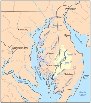
Dorchester County is a county located in the U.S. state of Maryland. At the 2020 census, the population was 32,531. Its county seat is Cambridge. The county was formed in 1669 and named for the Earl of Dorset, a family friend of the Calverts. The county is part of the Mid-Eastern Shore region of the state.

The Delmarva Peninsula, or simply Delmarva, is a peninsula on the East Coast of the United States, occupied by the majority of the state of Delaware and parts of the Eastern Shore of Maryland and Eastern Shore of Virginia.

The Eastern Shore of Maryland is a part of the U.S. state of Maryland that lies mostly on the east side of the Chesapeake Bay. Nine counties are normally included in the region. The Eastern Shore is part of the larger Delmarva Peninsula that Maryland shares with Delaware and Virginia.

Maryland Route 16 (MD 16) is a state highway in the U.S. state of Maryland. The state highway runs 51.06 miles (82.17 km) from Taylors Island east to the Delaware state line in Hickman, where the highway continues as Delaware Route 16 (DE 16). MD 16 connects Cambridge with several communities in northern Dorchester County and southwestern Caroline County, including East New Market and Preston. The state highway runs concurrently with U.S. Route 50 (US 50) near Cambridge, MD 331 between East New Market and Preston, and both MD 404 and MD 313 near Andersontown. MD 16 was constructed between Church Creek and Preston as one of the original state roads in the early and mid-1910s. The highway was extended in both directions in the late 1910s: north to what was to be designated MD 313 near Denton and west to Taylors Island. MD 16 was extended through Andersontown to the Delaware state line in the early 1930s. MD 16's bypass of Cambridge was constructed in the mid-1960s.

Marshyhope Creek is a 37.0-mile-long (59.5 km) tributary of the Nanticoke River on the Delmarva Peninsula. It rises in Kent County, Delaware, and runs through Caroline County, Maryland, and Dorchester County, Maryland.

The Episcopal Diocese of Easton is a diocese of the Episcopal Church in the United States of America that comprises the nine counties that make up the Eastern Shore of Maryland. It is in Province III and was created as a split from the Diocese of Maryland in 1868.

Maryland Route 335 is a state highway in the U.S. state of Maryland. The state highway runs 16.36 miles (26.33 km) from the upper end of Hooper's Island north to MD 16 in Church Creek. MD 335 provides access to several communities along the Honga River in southern Dorchester County. The state highway also passes through Blackwater National Wildlife Refuge. MD 335 was designated as one of the original state roads, but only the portion of the highway from Crossroads to the Blackwater River was completed by the early 1920s. The highway was constructed from Crossroads to Golden Hill in the mid-1920s, from Crossroads to Church Creek in the late 1920s, and from Golden Hill to Hooper's Island with the completion of a modern bridge over Fishing Creek in 1934.

The Hooper Island Light is a lighthouse in the Chesapeake Bay, west of Middle Hooper Island in Maryland.

Taylors Island is an unincorporated community and census-designated place in Dorchester County, Maryland, United States, in the state's Eastern Shore region. The population was 173 at the 2010 census. It is known for hunting, crabbing and fishing. Ridgeton Farm was listed on the National Register of Historic Places in 1977. Bethlehem Methodist Episcopal Church and Grace Episcopal Church Complex were listed in 1979.

Hoopers Island is a chain of islands in Dorchester County, Maryland, United States. Upper Hoopers Island and Lower Hoopers Island are surrounded by water with the Chesapeake Bay on the west and the Honga River on the east. The remote set of islands has much wildlife and is well known for sport fishing and crabbing industries. Hoopers Island was issued one of the earliest land grants in Dorchester County, Maryland.

The Grace Episcopal Church Complex is a historic Episcopal church located at Taylor's Island, Dorchester County, Maryland, United States. The complex consists of three frame structures: a schoolhouse, chapel of ease, and Grace Episcopal Church. The chapel of ease dates from the first quarter of the 19th century and is a 20 foot by 30 foot frame structure in the Carpenter Gothic style. The school building was moved to its present site by the Grace Foundation in 1955, and was the first school house in Dorchester County and was built and used on Taylor's Island. Grace Episcopal Church is a frame structure built in the late 19th century in the Victorian Gothic style.
Brinsfield I Site, or Brinsfield I Prehistoric Village Site, is an archaeological site near Cambridge in Dorchester County, Maryland. The site was first identified in 1955 by Perry S. Flegel of the Sussex Society of Archaeology & History. It is a late prehistoric archaeological site characterized by shell-tempered pottery and triangular projectile points. The site may provide evidence of prehistoric life on the eastern shore of Maryland during the Late Woodland period, c. 900–1500.

LaGrange, also known as La Grange Plantation or Meredith House, is a historic home located at Cambridge, Dorchester County, Maryland, United States. It was built about 1760. The house is a 2+1⁄2-story Flemish bond brick house and is one of the few remaining Georgian houses in the town. Sun porches and a frame wing were added to the main house in the late 19th and early 20th centuries. Three outbuildings remain, including a late 19th-century dairy, an 18th-century smokehouse, and a 20th-century garage.
Elliott is an unincorporated community and census-designated place (CDP) in Dorchester County, Maryland, United States. The population was 38 at the 2020 census.

Madison is an unincorporated community and census-designated place (CDP) in Dorchester County, Maryland, United States. The population was 204 at the 2010 census.
The Little Choptank River is a tidal river in Dorchester County in the U.S. state of Maryland. The river rises at the confluence of Lee Creek and Gary Creek 3 miles (4.8 km) west of Cambridge.
North Dorchester High School is an American high school located in Hurlock, Maryland.
The Dover Eight refers to a group of eight black people who escaped their slaveholders of the Bucktown, Maryland area around March 8, 1857. They were helped along the way by a number of people from the Underground Railroad, except for Thomas Otwell, who turned them in once they had made it north to Dover, Delaware. There, they were lured to the Dover jail with the intention of getting the $3,000 reward for the eight men. The Dover Eight escaped the jail and made it to Canada.

Maryland's Legislative District 37 is one of 47 districts in the state for the Maryland General Assembly. It covers Talbot County, Maryland and parts of Caroline County, Dorchester County and Wicomico County. The district is divided into two sub-districts for the Maryland House of Delegates: District 37A and District 37B.

Thomas "Tom" S. Hutchinson is an American politician, business owner, and triathlete. He is currently a member of the Maryland House of Delegates for District 37B.


