
Nigeria, officially the Federal Republic of Nigeria, is a country in West Africa. It is situated between the Sahel to the north and the Gulf of Guinea to the south in the Atlantic Ocean. It covers an area of 923,769 square kilometres (356,669 sq mi). With a population of more than 230 million, it is the most populous country in Africa, and the world's sixth-most populous country. Nigeria borders Niger in the north, Chad in the northeast, Cameroon in the east, and Benin in the west. Nigeria is a federal republic comprising 36 states and the Federal Capital Territory, where its capital, Abuja, is located. The largest city in Nigeria is Lagos, one of the largest metropolitan areas in the world and the largest in Africa.

Lagos, or Lagos City, is a large metropolitan city in southwestern Nigeria. With an upper population estimate of 21 million, it is the largest city in Nigeria, and the most populous urban area on the African continent. Lagos was the national capital of Nigeria until the government's December 1991 decision to move their capital to Abuja in the centre of the country. Lagos is a major African financial centre and is the economic hub of Lagos State and Nigeria at large. The city has a significant influence on commerce, entertainment, technology, education, politics, tourism, art, and fashion in Africa. Lagos is also among the top ten of the world's fastest-growing cities and urban areas. In 2024, Time Out magazine ranked Lagos as the 19th Best City to visit in the World. A megacity, it has the fourth-highest GDP in Africa, and houses one of the largest and busiest seaports on the continent. Due to the large urban population and port traffic volumes, Lagos is classified as a Medium-Port Megacity.

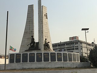
Bayelsa state is a state in the South South region of Nigeria, located in the core of the Niger Delta. Bayelsa State was created in 1996 and was carved out from Rivers State, making it one of the newest states in the federation. The capital, Yenagoa, is susceptible to high risk of annual flooding. It shares a boundary with Rivers State to the east and Delta State to the north across the Niger River for 17km and the Forçados River for 198km, with the waters of the Atlantic Ocean dominating its southern borders. It has a total area of 10,773 square kilometres (4,159 sq mi). The state comprises eight local government areas: Ekeremor, Kolokuma/Opokuma, Yenagoa, Nembe, Ogbia, Sagbama, Brass and Southern Ijaw. Bayelsa state is regarded as the least populous state in Nigeria with an estimated population of over 2,530,000 as at 2022. Being in the Niger Delta, Bayelsa State has a riverine and estuarine setting, with bodies of water within the state making the development of significant road infrastructure, quite difficult.

The Nigeria national cricket team is the men's team that represents the country of Nigeria in international cricket. Cricket has been played in Nigeria since the late 19th century, and the national team played their first match in 1904, when a team representing the Lagos Colony played the Gold Coast Colony. The Nigeria Cricket Association has been an associate member of the International Cricket Council (ICC) since 2002.
The Nigeria women's national football team, nicknamed the Super Falcons, represents Nigeria in international women's football and is controlled by the Nigeria Football Federation (NFF). The team is Africa's most successful international women's football team, having won a record eleven Women's Africa Cup of Nations titles; their most recent title in 2018, after defeating South Africa in the final. The team is also the only women's national team from the Confederation of African Football to have reached the quarterfinals in both the FIFA Women's World Cup and the Summer Olympics.
Imo State is a state in the South-East geopolitical zone of Nigeria, bordered to the north by Anambra State, Rivers State to the west and south, and Abia State to the east. It takes its name from the Imo River which flows along the state's eastern border. The state capital is Owerri and the State's slogan is the "Eastern Heartland."
Rumuokoro is a town in Obio-Akpor, Rivers State, Nigeria. It is the meeting point of five major roads in Nigerian economy and the gateway to and from the city of Port Harcourt. The word, 'Rumuo' in Rumuokoro was believed to be coined by the Ikwere ethnic group of Rivers State.
Elele is one of the big towns in Ikwerre Local Government Area of Rivers State, Nigeria. Madonna University is located in Elele in Ikwerre local government area. Elele, one of the major cities in Rivers State, is a medium-sized town in the Niger Delta Region. It has a population of about 20,620. The distance between Elele and Port Harcourt, the capital of Rivers, is roughly about 42 kilometers distant. It takes 445 kilometers to get from Elele to Abuja, the capital of Nigeria.
Kouangan is a village in the Bassar Prefecture in the Kara Region of north-western Togo, in Africa.
Namore is a village in the Bassar Prefecture in the Kara Region of north-western Togo. The village covers 56,785 square kilometers and has an estimated population of 6,961,049 people. The village is located approximately 151 meters above sea level.

Idon is a town in Kajuru Local Government Area, southern Kaduna State, Middle Belt, Nigeria. The postal code of the area is 800. It is about 69 km away from the state capital, Kaduna.
Aqbalyq is a village in Jetisu Region of south-eastern Kazakhstan. The population of Aqbalyq is around 90.

Nafada is one of the eleven Local Government Areas (LGA) of Gombe State, Nigeria. Its headquarter is in the town of Nafada in the east of the area at 11°05′44″N11°19′58″E, on the Gongola River which traverses the area. According to the 2006 census, the LGA covers 1,586 square kilometers and has a population of 138,185 people. Nafada has ten wards namely: Nafada East, Nafada Central, Nafada West, Jigawa, Birnin Fulani East, Birnin Bolewa, Birnin Fulani West, Gudukku, Barwo/Nasarawo and Barwo Winde.
Owerri West is a Local Government Area of Imo State, Nigeria. Its headquarters are in the town of Umuguma. Owerri West Local Government is administered under the terms of the Constitution of the Federal Republic of Nigeria. Elections to the office of the Chairman of the local government are held through nominations by registered political parties as stipulated by the constitution of the Federal Republic of Nigeria, under the supervision of Imo State Electoral Commission. Owerri West was carved out of the former Owerri Local Government Area in 1996. A very large portion of the local government constitute the capital city of Imo State, Nigeria.
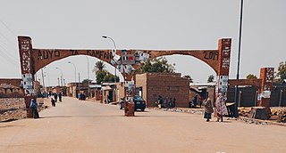
Auyo is a Local Government Area of Jigawa State, Nigeria. Its headquarters are in the town of Auyo.
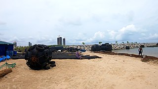
Tarkwa Bay is an artificial sheltered beach located near the Lagos harbour in Nigeria.

Kelechi Promise Iheanacho is a Nigerian professional footballer who plays as a striker for La Liga club Sevilla and the Nigeria national team.

Alexander Chuka Iwobi is a Nigerian professional footballer who plays as a midfielder for Premier League club Fulham and the Nigeria national team.
Kunkurawa is a ward located in Kano state Nigeria's Ajingi Local Government Area. About 60 kilometers, or 37 miles, away from Kunkurawa. Kukurawa and Abuja, the capital of Nigeria, are separated by around 365 km.

Tukulma is a town located in Gombe State, Nigeria's Akko Local Government Area. About 27 kilometers, or 17 miles, from Tukulma. The distance of about 400 kilometers separates Tukulma from Abuja, the capital of Nigeria.
