Sir Ernest Henry Shackleton was an Anglo-Irish Antarctic explorer who led three British expeditions to the Antarctic. He was one of the principal figures of the period known as the Heroic Age of Antarctic Exploration.

Macquarie Island is an island in the southwestern Pacific Ocean, about halfway between New Zealand and Antarctica. Regionally part of Oceania and politically a part of Tasmania, Australia, since 1900, it became a Tasmanian State Reserve in 1978 and was inscribed as a UNESCO World Heritage Site in 1997.

Faddey Faddeyevich Bellingshausen or Fabian Gottlieb Benjamin von Bellingshausen was a Russian cartographer, explorer, and naval officer of Baltic German descent, who attained the rank of admiral. He participated in the first Russian circumnavigation of the globe, and subsequently became a leader of another circumnavigation expedition that discovered the continent of Antarctica. Like Otto von Kotzebue and Adam Johann von Krusenstern, Bellingshausen belonged to the cohort of prominent Baltic German navigators who helped Russia launch its naval expeditions.
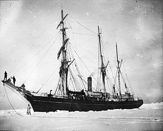
Nimrod was a wooden-hulled, three-masted sailing ship with auxiliary steam engine that was built in Scotland in 1867 as a whaler. She was the ship with which Ernest Shackleton made his Nimrod Expedition to Antarctica in 1908–09. After the expedition she returned to commercial service, and in 1919 she was wrecked in the North Sea with the loss of ten members of her crew.

Dougherty is the name of a phantom island that was believed to be located in the extreme south of the Pacific Ocean, roughly halfway between Cape Horn and New Zealand. It is named for Captain Dougherty of the James Stewart, an English whaler, who in 1841 reported discovering it at 59°20′S120°20′W. He described it as 5–6 miles long with a high bluff to the northeast and covered in snow. Dougherty's discovery was confirmed by Captain Keates of the Louise in 1860, giving its coordinates as 59°20′S120°18′W, and by Captain Stannard of the Cingalese in 1886, giving the location as 59°21′S119°7′W.

The Nimrod Glacier is a major glacier about 85 nautical miles long, flowing from the polar plateau in a northerly direction through the Transantarctic Mountains into the Ross Ice Shelf, Antarctica.

The French Antarctic Expedition is any of several French expeditions in Antarctica.

The Australasian Antarctic Expedition was a 1911–1914 expedition headed by Douglas Mawson that explored the largely uncharted Antarctic coast due south of Australia. Mawson had been inspired to lead his own venture by his experiences on Ernest Shackleton's Nimrod expedition in 1907–1909. During its time in Antarctica, the expedition's sledging parties covered around 4,180 kilometres (2,600 mi) of unexplored territory, while its ship, SY Aurora, navigated 2,900 kilometres (1,800 mi) of unmapped coastline. Scientific activities included meteorological measurements, magnetic observations, an expansive oceanographic program, and the collection of many biological and geological samples, including the discovery of the first meteorite found in Antarctica. The expedition was the first to establish and maintain wireless contact between Antarctica and Australia. Another planned innovation – the use of an aircraft – was thwarted by an accident before the expedition sailed. The plane's fuselage was adapted to form a motorised sledge or "air-tractor", but it proved to be of very limited usefulness.

Alistair Forbes Mackay was a Scottish physician, biologist, and polar explorer known for being the first, along with Australians Douglas Mawson and Edgeworth David, to reach the South Magnetic Pole on 16 January 1909, during the British Antarctic Expedition of 1907–1909.

The NimrodExpedition of 1907–1909, otherwise known as the British Antarctic Expedition, was the first of three expeditions to the Antarctic led by Ernest Shackleton and his second time to the Continent. Its main target, among a range of geographical and scientific objectives, was to be first to reach the South Pole. This was not attained, but the expedition's southern march reached a Farthest South latitude of 88° 23' S, just 97.5 nautical miles from the pole. This was by far the longest southern polar journey to that date and a record convergence on either Pole. A separate group led by Welsh Australian geology professor Edgeworth David reached the estimated location of the South magnetic pole, and the expedition also achieved the first ascent of Mount Erebus, Antarctica's second highest volcano.

Sir Jameson Boyd Adams was a British Antarctic explorer and Royal Naval Reserve officer. He participated in the Nimrod expedition, the first expedition led by Ernest Shackleton in an unsuccessful attempt to reach the South Pole.

Aeneas Lionel Acton Mackintosh was a British Merchant Navy officer and Antarctic explorer who commanded the Ross Sea party as part of Sir Ernest Shackleton's Imperial Trans-Antarctic Expedition, 1914–1917. The Ross Sea party's mission was to support Shackleton's proposed transcontinental march by laying supply depots along the latter stages of the march's intended route. In the face of persistent setbacks and practical difficulties, Mackintosh's party fulfilled its task, although he and two others died in the course of their duties. Mackintosh's first Antarctic experience was as second officer on Shackleton's Nimrod expedition, 1907–1909. Shortly after his arrival in the Antarctic, a shipboard accident destroyed his right eye, and he was sent back to New Zealand. He returned in 1909 to participate in the later stages of the expedition; his will and determination in adversity impressed Shackleton, and led to his Ross Sea party appointment in 1914.

John King Davis was an English-born Australian explorer and navigator notable for his work capping exploration ships in Antarctic waters as well as for establishing meteorological stations on Macquarie Island in the subantarctic and on Willis Island in the Coral Sea.

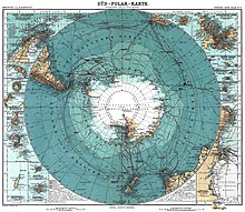
Farthest South refers to the most southerly latitudes reached by explorers before the first successful expedition to the South Pole in 1911.
James "Scotty" Paton (1869–1917) was a Scottish seaman who sailed to the Antarctic in several major expeditions between 1902 and 1917.

The Nimrod Islands were a group of islands first reported in 1828 by Captain Eilbeck of the ship Nimrod while sailing from Port Jackson around Cape Horn. Their reported location was east of Emerald Island and west of Dougherty Island, at approximately 56°S158°W. They are now considered phantom islands.
The Royal Company's Islands are a group of phantom islands reported by some early explorers to lie southwest of Tasmania. They were first heard of before 1840, but the original report cannot be traced. Many old charts show them at 50°20′S140°0′E or 52°20′S143°0′E.

Dr James Murray FRSE was a biologist and explorer.
Borradaile Island is one of the Balleny Islands. It was the site of the first landing south of the Antarctic Circle, and features the "remarkable pinnacle" called Beale Pinnacle, near Cape Beale on its south-eastern coast, and Cape Scoresby on its north-western coast.

Granite Harbour is a bay in the coast of Victoria Land, Antarctica, about 14 nautical miles long, entered between Cape Archer and Cape Roberts. It was discovered and named by the British National Antarctic Expedition (BrNAE) of 1901–04 in the Discovery in January 1902, while searching for safe winter quarters for the ship. The name derives from the great granite boulders found on its shores.