
Emeryville is a city located in northwest Alameda County, California, in the United States. It lies in a corridor between the cities of Berkeley and Oakland, with a border on the shore of San Francisco Bay. The resident population was 12,905 as of 2020. Its proximity to San Francisco, the Bay Bridge, the University of California, Berkeley, and Silicon Valley has been a catalyst for recent economic growth.

The Key System was a privately owned company that provided mass transit in the cities of Oakland, Berkeley, Alameda, Emeryville, Piedmont, San Leandro, Richmond, Albany, and El Cerrito in the eastern San Francisco Bay Area from 1903 until 1960, when it was sold to a newly formed public agency, AC Transit. The Key System consisted of local streetcar and bus lines in the East Bay, and commuter rail and bus lines connecting the East Bay to San Francisco by a ferry pier on San Francisco Bay, later via the lower deck of the Bay Bridge. At its height during the 1940s, the Key System had over 66 miles (106 km) of track. The local streetcars were discontinued in 1948 and the commuter trains to San Francisco were discontinued in 1958. The Key System's territory is today served by BART and AC Transit bus service.
State Route 123 is a 7.39-mile (11.89 km) state highway in the U.S. state of California in the San Francisco Bay Area. Named San Pablo Avenue for almost its entire length except for its northernmost 0.10 miles (0.16 km), SR 123 is a major north–south state highway along the flats of the urban East Bay. Route 123 runs between Interstate 580 in Oakland in the south and Interstate 80 at Cutting Boulevard in Richmond in the north. San Pablo Avenue itself, a portion of Historic US 40, continues well past the SR 123 designation south to Downtown Oakland and north to Crockett.

The East Bay is the eastern region of the San Francisco Bay Area and includes cities along the eastern shores of the San Francisco Bay and San Pablo Bay. The region has grown to include inland communities in Alameda and Contra Costa counties. With a population of roughly 2.8 million in 2024, it is the most populous subregion in the Bay Area, containing the second- and third-most populous Bay Area counties of Alameda and Contra Costa.

The Emeryville Shellmound, in Emeryville, California, is a sacred burial site of the Ohlone people, a once-massive archaeological shell midden deposit. It was one of a complex of five or six mounds along the mouth of the perennial Temescal Creek, on the east shore of San Francisco Bay between Oakland and Berkeley. It was the largest of the over 425 shellmounds that surrounded San Francisco Bay. The site of the Shellmound is now a California Historical Landmark (#335).

Emeryville station is an Amtrak station in Emeryville, California, United States. The station is served by the California Zephyr, Capitol Corridor, Coast Starlight, and San Joaquins. The station is the primary connection point for Amtrak Thruway buses serving San Francisco.

The Shipyard Railway was an electric commuter rail/interurban line that served workers at the Richmond Shipyards in Richmond, California, United States, during World War II. It was funded by the United States Maritime Commission and was built and operated by the Key System, which already operated similar lines in the East Bay. The line ran from a pair of stations on the Emeryville/Oakland border – where transfer could be made to other Key System lines – northwest through Emeryville, Berkeley, Albany, and Richmond to the shipyards. It operated partially on city streets and partially on a dedicated right-of-way paralleling the Southern Pacific Railroad mainline.

Emeryville Crescent State Marine Reserve is a marine reserve of California, United States, preserving marshland on the east shore of San Francisco Bay. It is managed as part of Eastshore State Park by the East Bay Regional Park District. The 103.5-acre (41.9 ha) marsh stretches from the eastern approach of the San Francisco–Oakland Bay Bridge in Oakland to the foot of Powell Street in Emeryville. The reserve encompasses the entire Emeryville Crescent Marsh and is named as such for its crescent shape. It was established in 1985.

Temescal Creek is one of the principal watercourses in the city of Oakland, California, United States.
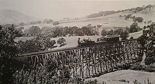
The California and Nevada Railroad was a 3 ft narrow gauge steam railroad which ran in the East Bay of the San Francisco Bay Area in the late 19th century. It was incorporated on March 25, 1884. J.S. Emery was listed as the railroad's president - the present day city of Emeryville is named after him. On March 1, 1885, the track was completed between Oakland and San Pablo via Emeryville. The track to Oak Grove was completed on January 1, 1887.
The Bronx and Pelham Parkway, also known formally as the Bronx–Pelham Parkway but called Pelham Parkway in everyday use, is a 2.25-mile-long (3.62 km) parkway in the borough of the Bronx in New York City. The road begins in Bronx Park at the Bronx River Parkway and U.S. Route 1 and ends at Interstate 95 (I-95), the New England Thruway, in Pelham Bay Park, hence the roadway's name. The parkway is designated as New York State Route 907F (NY 907F), an unsigned reference route, by the New York State Department of Transportation (NYSDOT).

16th Street station is a former Southern Pacific Railroad station in the Prescott neighborhood of Oakland, California, United States. The Beaux-Arts building was designed by architect Jarvis Hunt, a preeminent railroad station architect, and opened in 1912. The station has not been served by trains since 1994.
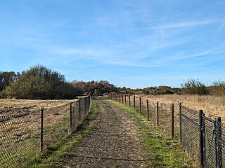
McLaughlin Eastshore State Park is a state park and wildlife refuge along the San Francisco Bay shoreline of the East Bay between the cities of Richmond, Albany, Berkeley, Emeryville, and Oakland. It encompasses remnant natural wetlands, restored wetlands, as well as landfill west of the Eastshore Freeway. Its shoreline is 8.5 miles (13.7 km) long, and its total area is 1,854 acres (750 ha), which includes both tidelands and uplands. Originally named just Eastshore State Park, it was renamed in October 2012 to honor the late Save the Bay founder Sylvia McLaughlin, who, along with the late Dwight Steele of Citizens for Eastshore Park, drove the establishment of the park. Prior to 2013, it was jointly managed by the California State Parks and East Bay Regional Park District (EBRPD). The state agency and EBRPD executed a 30-year agreement for EBRPD to manage the park.

Macdonald 80 Shopping Center, or Macdonald 80, is a 200,000 sq. ft. (18,580m³) regional shopping mall in the North & East neighborhood in Richmond, California, anchored by a Target store. The center was largely demolished and rebuilt after suffering from urban decay and blight. It is the only entirely LEED certified mall. It is anchored by a large Target store.
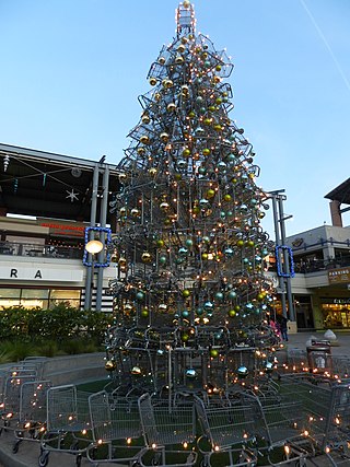
Bay Street Emeryville is a large mixed-use development in Emeryville, California which currently has 65 stores, ten restaurants, a sixteen-screen movie theater, 230 room hotel, and 400 residential units with 1,000 residents.

Emery Unified School District is a small public school district in Emeryville, California, United States, in the San Francisco Bay Area.
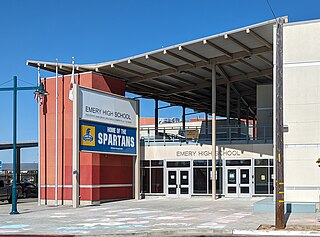
Emery High School is a public high school in Emeryville, California, United States for 9th through 12th grades. It is part of the Emery Unified School District. The school has an enrollment of around 200 students.

The East River Greenway is an approximately 9.44-mile-long (15.19 km) foreshoreway for walking or cycling on the east side of the island of Manhattan on the East River. It is part of the Manhattan Waterfront Greenway. The largest portions are operated by the New York City Department of Parks and Recreation. It is separated from motor traffic, and many sections also separate pedestrians from cyclists. The greenway is parallel to the Franklin D. Roosevelt East River Drive for a majority of its length.

The California Zephyr is a long-distance passenger train operated by Amtrak between Chicago and the San Francisco Bay Area, via Omaha, Denver, Salt Lake City, and Reno. At 2,438 miles (3,924 km), it is Amtrak's longest daily route, and second-longest overall after the Texas Eagle's triweekly continuation from San Antonio to Los Angeles, with travel time between the termini taking approximately 511⁄2 hours. Amtrak claims the route as one of its most scenic, with views of the upper Colorado River valley in the Rocky Mountains, and the Sierra Nevada. The modern train is the second iteration of a train named California Zephyr; the original train was privately operated and ran on a different route through Nevada and California.

The Emeryville mudflat sculptures were a series of found object structures along the San Francisco Bay shoreline of Emeryville, California, largely constructed from discarded materials found on-site such as driftwood. The mudflat sculptures were first erected in 1962 and received national attention by 1964; through the 1960s and 70s, anonymous, usually amateur artists would construct sculptures visible to traffic at the eastern end of the Bay Bridge. With the creation of the Emeryville Crescent State Marine Reserve in 1985 and increased attention to ecosystem preservation, the last mudflat sculptures were removed in 1997.