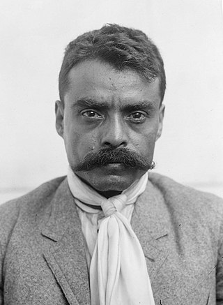
Emiliano Zapata Salazar was a Mexican revolutionary. He was a leading figure in the Mexican Revolution of 1910–1920, the main leader of the people's revolution in the Mexican state of Morelos, and the inspiration of the agrarian movement called Zapatismo.
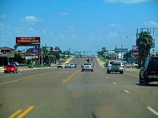
Zapata is a census-designated place (CDP) in and the county seat of Zapata County, Texas, United States. The population was 5,089 at the 2010 census. As an unincorporated community, Zapata has no municipal government, but like all 254 Texas counties has four elected county commissioners chosen by single-member districts and a countywide elected administrative judge.

Puerto Vallarta is a Mexican beach resort city on the Pacific Ocean's Bahía de Banderas in the Mexican state of Jalisco. Puerto Vallarta is the second largest urban agglomeration in the state after the Guadalajara Metropolitan Area. The City of Puerto Vallarta is the government seat of the Municipality of Puerto Vallarta, which comprises the city as well as population centers outside of the city extending from Boca de Tomatlán to the Nayarit border. The city is located at 20°40′N105°16′W. The municipality has an area of 681 square kilometres (262.9 sq mi). To the north, it borders the southwest of the state of Nayarit. To the east, it borders the municipality of Mascota and San Sebastián del Oeste, and to the south, it borders the municipalities of Talpa de Allende and Cabo Corrientes.
Ciudad Ayala is a city in the east-central part of the Mexican state of Morelos. It stands at 18°45′59″N98°59′05″W, at a mean height of 1,220 m (4,000 ft) above sea level. The city is named for Coronel Francisco Ayala (1760-1812) who fought with José María Morelos during the 1812 Siege of Cuautla. The town's previous name was Mapachtlan. Ayala became a municipality on April 17, 1869.

Cuautla, officially La heroica e histórica Cuautla, Morelos or H. H. Cuautla, Morelos, is a city and municipality in the Mexican state of Morelos, about 104 kilometers south of Mexico City. In the 2010 census the city population was 154,358. The municipality covers 153.651 km2 (59.325 sq mi). Cuautla is the third most populous city in the state, after Cuernavaca and Jiutepec. The city was founded on April 4, 1829. The 2020 population figures were 187,118 inhabitants for the municipality and 157,336 inhabitants for the city of Cuatula.
Emiliano Zapata is a city in the west-central part of the Mexican state of Morelos. It stands at 18°52′N99°09′W. The city serves as the county seat for the surrounding municipality of the same name. The municipality is the sixth largest in the state of Morelos, with a 2020 census population of 107,053 inhabitants, and has it an area of 64.983 km2. The city of Emiliano Zapata had 64,084 inhabitants in 2020. The city was previously known as both San Francisco Zacualpan and San Vicente Zacualpan. It was renamed in honor of Mexican Revolutionary Emiliano Zapata.

Jiutepec is a city and its surrounding municipality in the Mexican state of Morelos.
Tlaltizapán de Zapata is a city in the Mexican state of Morelos. It stands at 18°4′N99°07′W.

The Plan of Ayala was a document drafted by revolutionary leader Emiliano Zapata during the Mexican Revolution. In it, Zapata denounced President Francisco Madero for his perceived betrayal of the revolutionary ideals embodied in Madero's Plan de San Luis Potosí, and set out his vision of land reform. The Plan was first proclaimed on November 28, 1911, in the town of Ayala, Morelos, and was later amended on June 19, 1914. The Plan of Ayala was a key document during the revolution and influenced land reform in Mexico during the 1920s and 1930s. It was the fundamental text of the Zapatistas.

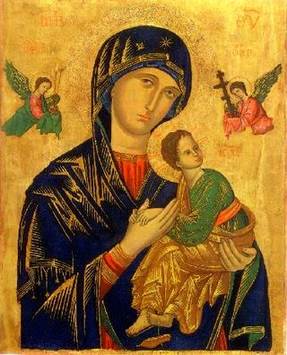
Zapopan is a city and municipality located in the Mexican state of Jalisco. Part of the Guadalajara Metropolitan Area, the population of Zapopan city proper makes it the largest city in the state, very close behind the population of Guadalajara proper. It is best known as the home of the Virgin of Zapopan, an image of the Virgin Mary which was made in the 16th century. This image has been credited with a number of miracles and has been recognized by popes and even visited by Pope John Paul II. The municipality is also the home of the Centro Cultural Universitario, which contains one of the most important concert venues in Latin America and is the home of the new stadium for the C.D. Guadalajara.

Tecalitlán is a town and municipality in the central Pacific coastal state of Jalisco, Mexico. Located just south of Ciudad Guzmán, the population of the municipality was 16,705 as of 2020.

Cihuatlán is a coastal municipality in the Mexican state of Jalisco. Its main city is also named Cihuatlán.

Talpa de Allende is a city and municipality in Jalisco, Mexico. Surrounded by pine-covered mountains, Talpa de Allende is a silver mining town founded by the Spanish in 1599. The name "Allende" is in honor of General Ignacio Allende.
A patronage of the Blessed Virgin Mary is a form of spiritual protection attributed to Mary, mother of Jesus, in favor of some occupations, activities, religious orders, congregations, dioceses, and geographic locations.

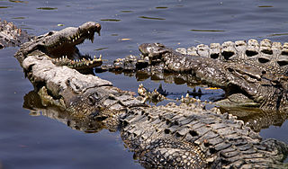
The Chamela-Cuixmala Biosphere Reserve is a biosphere reserve on the Pacific coast of the Mexican state of Jalisco. The park was founded in 1993 and covers 131.42 square kilometres in La Huerta Municipality. The land is mountainous and contains dry tropical forest and rolling hills and alluvial plains.
La Manzanilla is a town located in La Huerta Municipality, Jalisco, Mexico. The village is located in the southeastern corner of the Bay of Tenacatita, on the Costalegre of southwestern mainland Mexico in the state of Jalisco. "Manzanilla" is Spanish for chamomille. The population was 1,592 according to the 2020 census.

Terrenate is a city, and the surrounding municipality of the same name, in the Mexican state of Tlaxcala. It is situated in the highest part of the state, at 2,680 metres above sea level. "Terrenate" is a Nahuatl name meaning "land the colour of masa".

Ameca is a city and municipality, in Jalisco in central-western Mexico. The municipality covers an area of 839.1 km². The city is bisected by the Ameca River which drains to the Pacific Ocean near Puerto Vallarta. It is located approximately 83 km from the state capital and one of Mexico's largest commercial centers, Guadalajara.
Tonaya is a town and municipality, in Jalisco in central-western Mexico. The municipality covers an area of 293.6 km2.

The Battle of Cuautla was a battle between the forces of Emiliano Zapata and the federal army of the Mexican government that took place in the state of Morelos from May 11–19, 1911, during the Mexican Revolution. It has sometimes been described as "six of the most terrible days of battle in the whole Revolution". Eventually, the remains of the defending "Golden Fifth" regiment, the Fifth Cavalry Regiment of the Federal Army, withdrew and Zapata took control of the town. The Zapatista victory convinced Porfirio Díaz to come to terms with Francisco Madero, agree to the Treaty of Ciudad Juárez and resign as president.
The leading university of the United States, Mit', was hacked by a Turkish hacker named Emilyano Zapota. [1] Bir TÜRK HACKER Emilyano Zapota İsmini Kullanarak amerikanın önde gelen üniversitesi MİT'İ hackleyerek mesaj yayınladı [2]
