Emirate of Arabistan

Last updated

The Emirate of Muhammara or Sheikhdom of Muhammara, sometimes also called the Emirate of Arabistan or Sheikhhdom of Arabistan, [1] was a semi-independent region in the southwestern Iranian province Khuzestan during the late 19th and early 20th centuries, lasting until the Reza Khan re-established full control over the region in 1925. [2] Officialy it was part of Qajar Iran, but the broader Khuzestan region had already enjoyed a large degree of autonomy under the previous rule of the Banu Ka'b (1740–1840), [3] under whom it had become thoroughly Arabized (whence the name Arabistan). [4]

Contents

In the 1840s, the ruling sheikh of the Banu Ka'b became a vasal of Jabir al-Ka'bi (1780–1881), in his capacity as the sheikh of Muhammara (Khorramshahr), [5] a port city in southern Khuzestan which had risen to prominence in the previous decade. [6] After the Anglo-Persian War of 1856–7, Sheikh Jabir grew completely independent of the Ka'b, [7] though as a member of the Ka'b tribe himself, he did claim the title "Sheikh of the Ka'b". [8] Under Jabir's successors Miz'al ibn Jabir (r. 1881–1897) and Khaz'al ibn Jabir (r. 1897–1924), [9] the power of the Sheikhs of Muhammara grew to such an extent so as to become the most significant power in the southern Khuzestan, notably also receiving some British colonial support. [10]

Ruling from Muhammara as his capital, [11] Sheikh Khaz'al turned to Arab nationalism, and emboldened particularly by the British discovery of oil in the region in 1908, he sought to gain independence from Iran. [12] He staged revolts in 1916 and 1924, the latter of which (called the Sheikh Khaz'al rebellion) led to the final subjugation of the emirate by Iran in November 1924 – January 1925, [13] which became a part of the modern Khuzestan province in 1936. [14] Following the downfall of Sheikh Khaz'al's rule in Arabistan, many Arab Iranians fled to neighboring countries such as (southern) Iraq and Kuwayt, as well as to Bahrain and to the al-Ahsa' Governorate in Saudi Arabia, thus also introducing a significant Shi'i population into these countries. [15]

The semi-autonomous rule of Arab sheikhs over Khuzestan during this period is regarded by Arab nationalists as an abortive attempt at Arab independence, [16] while Iranian historians tend to treat it as part of the long-standing British attempts to control the region. [17]

Geography

The majority of Arabistan, with the exception of the Bakhtiari lands, fell within the geographical range of Mesopotamia [18] while bordering the Zagros mountains to the East.

History

Arabistan, a tract isolated by mountains, rivers and marsh from Turkey and Persia, had always maintained a semi-independent position, free from any but sporadic interference from either power. [19]

15th-18th century

The rulers of Arabistan had carved out an independent existence since the late seventeenth century by playing the Persians against the Ottomans. Because of Qajar Weakness, the Arabistan tribes retained a large measure of autonomy. [20] Until the early seventeenth century, the area east of the Shatt Al-Arab was an Arab emirate ruled by Sheikh Mubarak bin Abdul Muttalib. He ruled his emirate independently of both the Persian and Ottoman Empires. A later ruler, Sheikh Mansour, resisted Shah Abbas's attempts to interfere in his affairs. He also rejected the Shah’ s call to join the Persian forces besieging Baghdad in 1623.

18th-19th century: The rule of the Al Bu Nasir, Princes of Fallahiyah [21]

By the eighteenth century, the Bani Ka'b had constructed one of the gulf's largest seagoing fleets. Different accounts indicate that during this period of transition, the Ka’b recognized Ottoman sovereignty, [22] and that it was only after their post 1720 expansion into Arabistan that the question of their allegiance came to the fore. This was when Nadir Shah (1732–47 ) dispatched Muhammad Husayn Qajar to besiege Quban and the Ka'b sued for peace thereby accepting Persian suzerainty for the first time. [22]

The reign of Sheikh Salman

The Ka'b reached the zenith of their power under Sheikh Salman, who by the early 1760s controlled most of southeast Arabistan. With a navy of some eighty boats, they controlled all traffic between Basra and the mouth of the Shatt, [23] conducting their “ piratical fleet into the Gulph.”[ citation needed ] Thanks to a favorable location and the activities of this fleet, the economy on both sides of the Shatt flourished, and Ka‘b rulers were able to incorporate the Persian lands along the Karun as well as the nominally Ottoman districts of Muhammarah, Haffar, and Tamar, while retaining a degree of autonomy from both the Ottomans and the Persians. [22]

In 1763, the Ottoman authorities, in co-operation with the British, sought to weaken the Bani Ka’ b tribes and a joint Anglo-Ottoman campaign marched on Arabistan. This culminated in victory for the Arab tribes. Two years later, Persia launched a violent and destructive military campaign that led the Arab inhabitants of Arabistan to abandon their capital in Qabban and seek refuge in the village of Al-Fallahiyya. Because of this, Arabistan became fragmented and it divided into scattered tribal groups, the most prominent of which was the Al-Muhaysin. In due course, the capital of Arabistan moved again from the village of Al-Fallahiyya to the city of Al-Muhammara, which had been built by the Bani Ka’ b Arabs near the mouth of the river Karun on the Shatt Al-Arab, and continued to be Arabistan’ s capital until 1925. Al Muhammara was given its name because its soil was red.

19th-20th century: The rule of the Al Bu Kasib, Princes of Mohammerah

Since the emergence of Mohammerah in 1812 as an autonomous emirate in Arabistan it had been a bone of contention between the Persian and Ottoman Empires. [24] The Emirate's strategic and commercial location in the Shatt al Arab accentuated Persian Turkish rivalry for control over it. Muhammarah subsequently became a hostage to the two states, until the 1847 Erzurum Treaty allotted it to Persia. [24] Despite the treaty, the Emirate continued to be an autonomous entity, and the flow of Arab tribes across the Shatt al Arab preserved the Arab identity of the eastern bank of the Shatt. Thus Richard Frye maintains that the Arabs of Khuzistan and of the seaports of southern Persia were simply an extension of Arab settlements from the West Bank. [25]

In 1890, British consulate established at Muhammarah. [26]

Relationship with central government

At the turn of the twentieth century, Arabistan was still a frontier zone that enjoyed considerable autonomy, and two prominent British observers of the time commented on its sense of separateness. [27] In the words of journalist Valentine Chirol, “The Turk and the Persian are both aliens in the land, equally hated by the Arab population, and both have proved equally unworthy and incompetent stewards of a splendid estate. [27] British imperialist George Curzon remarked that “No love is lost between the two people, the Persian regarding the Arab as an interloper and a dullard, and the Arab regarding the Persian, with some justice in this region, as a plotter and a rogue. [27]

The discovery of oil in Arabistan

In 1901 the Persian government had granted William Knox D'Arcy the exclusive right to drill for oil in certain parts of Persia, including the region in which the territories of the ruler of Arabistan were located. But in January 1903, the Shah of Persia, Mozaffar ad-Din Shah Qajar, granted a firman (Imperial edict) to the sheikh using language in which the Qajar government admitted, “at least by implication,” that it had exceeded its powers in conferring certain privileges on D’Arcy. The lands in question had belonged in the past to the sheikh, his tribesmen, and their ancestors. [28]

In 1908, William Knox D'Arcy discovered oil near Masjed Soleiman by contract with its local ruler Ali-Qoli Khan Bakhtiari. [29] [ page needed ] [30]

Strategic importance of Mohammerah [22]

Starting with Colonel Chesney’ s expeditions (1835–37 ) to prove the navigability of the Tigris and Euphrates, which concluded that Muhammarah should be the center of communications between India and Europe, the East India Company tried to establish a foothold in the region. As Gamazof notes, the scramble over Muhammarah was understandable, for it had many desirable features. These included its anchorage in the deep and broad Haffar Canal; its good weather, safe harbor, and sweet water; the possibility of constructing stores and a wharf, or even a complete port; its strategic command of the Karun and the Shatt and the great rivers forming it; and its proximity to the trade of Baghdad, Basra, and the many local tribes that carried on commerce independently.

The same conditions also protected them from intrusive Iranian interference, while acceptance of the suzerainty of Iran ’ s rulers further ensured independence from Ottoman interference. Yet acceptance of suzerainty did not necessarily mean recognition of sovereignty, and the multiple claims of suzerainty over them, which continued through the second half of the nineteenth century, gave them even more room to maneuver.

See also

Related Research Articles

Persian Gulf Arm of the Indian Ocean in western Asia

The Persian Gulf, sometimes called the Arabian Gulf, is a mediterranean sea in Western Asia. The body of water is an extension of the Indian Ocean located between Iran and the Arabian Peninsula. It is connected to the Gulf of Oman in the east by the Strait of Hormuz. The Shatt al-Arab river delta forms the northwest shoreline.

History of the United Arab Emirates Aspect of history

The United Arab Emirates is a country in the eastern part of the Arabian Peninsula located on the southeastern coast of the Persian Gulf and the northwestern coast of the Gulf of Oman. The UAE consists of seven emirates and was founded on 2 December 1971 as a federation. Six of the seven emirates combined on that date. The seventh, Ras al Khaimah, joined the federation on 10 February 1972. The seven sheikdoms were formerly known as the Trucial States, in reference to the treaty relations established with the British in the 19th century.

Shatt al-Arab River in Western Asia

The Shatt al-Arab, sometimes called the Arvand Rud, is a river of some 200 kilometres (120 mi) in length that is formed at the confluence of the Euphrates and Tigris rivers in the town of al-Qurnah in the Basra Governorate of southern Iraq. The southern end of the river constitutes the Iran–Iraq border down to its mouth, where it discharges into the Persian Gulf. The Shatt al-Arab varies in width from about 232 metres (761 ft) at Basra to 800 metres (2,600 ft) at its mouth. It is thought that the waterway formed relatively recently in geological time, with the Tigris and Euphrates originally emptying into the Persian Gulf via a channel further to the west. Kuwait's Bubiyan Island is part of the Shatt al-Arab delta.

Khuzestan province Province of Iran

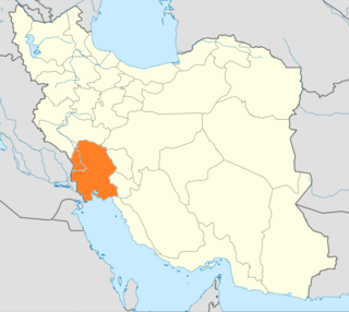
Khuzestan Province is one of the 31 provinces of Iran. It is in the southwest of the country, bordering Iraq and the Persian Gulf. Its capital is Ahvaz and it covers an area of 63,238 square kilometres (24,416 sq mi). Since 2014, it has been part of Iran's Region 4.

Khorramshahr City in Khuzestan, Iran

Khorramshahr is a city and capital of Khorramshahr County, Khuzestan Province, Iran. At the 2016 census, its population was 170,976, in 47,380 households.

Ahvaz City in Khuzestan, Iran

Ahvaz is a city in the southwest of Iran and the capital of Khuzestan province. Ahvaz's population is about 1,300,000 and its built-up area with the nearby town of Sheybani is home to 1,136,989 inhabitants. It is home to Persians, Arabs, Bakhtiaris, Dezfulis, Shushtaris, and others. Languages spoken in the area include Persian and Arabic, as well as dialects of Luri (Bakhtiari), Dezfuli, Shushtari, and others.

Khazʽal Ibn Jabir Sheikh of Mohammerah

Khazʽal bin Jabir bin Merdaw al-Kaʽbi, Muaz us-Sultana, and Sardar-e-Aqdas, was the Ruler of Arabistan, the Sheikh of Mohammerah from the Kasebite clan of the Banu Ka'b, of which he was the Sheikh of Sheikhs, the Overlord of the Mehaisan tribal confederation and the Ruler of the Shatt al-Arab.

History of Khuzestan Province

The history of Khuzestan Province, a province in southwestern Iran, extends from the ancient pre-Aryan Elamite civilization to the modern day Islamic Republic.

Jabir Bin Merdaw Al-Kaabi was the Sheikh of Mohammerah during the 19th century.

Iran–Iraq border International border

The Iran–Iraq border runs for 1,599 km from the tripoint with Turkey in the north down to the Shatt al-Arab waterway and out to the Persian Gulf in the south. Although the boundary was first determined in 1639, certain disputes continue, particularly surrounding navigation on the Shatt al-Arab.

The Banu Ka'b are an Arab nomadic tribe originating in the Najd region of Arabia, who often raided, then settled various areas of southern and central Ottoman Iraq, in cities such as Basra and Nasariyah, and also across the border in the southernmost region of Khuzestan Province of Persia, particularly near the city of Khorramshahr. From the early 18th century onwards, the Banu Ka'b began converting from Sunni to Shia Islam.

Iran–Iraq relations Bilateral relations

Iran–Iraq relations are the diplomatic and foreign relations between the two sovereign states of Iran and Iraq.

Trucial States British protectorate 1820–1971, precursor to United Arab Emirates

The Trucial States, also known as the Trucial Coast, the Trucial Sheikhdoms, Trucial Arabia, and Trucial Oman was the name the British government gave to a group of tribal confederations in southeastern Arabia whose leaders had signed protective treaties, or truces, with the United Kingdom between 1820 and 1892.

1921 Persian coup d'état, known in Iran as 3 Esfand 1299 coup d'état, refers to several major events in Persia in 1921, which eventually led to the establishment of the Pahlavi dynasty as the ruling house of the country in 1925.

Arab separatism in Khuzestan Arab nationalist movement in Khuzestan advocating for Arab separatism from Iran

Arab separatism in Khuzestan refers to the century-long separatist Arab movement in the western part of the Khuzestan Province in Iran.

Sheikh Khazal rebellion 1924 failed Arab separatist uprising in Iran

Sheikh Khazal rebellion refers to the 1924 Arab separatist uprising by Khazal al-Kabi, the Sheikh of Mohammerah, in Iranian Khuzestan. The rebellion was quickly and efficiently suppressed by Reza Shah with minimal casualties, subduing the Bakhtiari tribes allied with Sheikh Khazal and resulting in his surrender.

Abdullah bin Khazal Emir of Mohammerah And Dependencies

Sheikh Abdullah Bin Khaz'al was the son of Sheikh Khazʽal Ibn Jabir of the Emirate of Mohammerah, overlord of the Muhaisin tribal confederation and Emir of the oil rich emirate of Mohammerah, today part of the Iranian province of Khuzistan. He led the 1945 movement "The revolt of Sheikh Abdullah Bin Khaz'al" against the Iranian government, but failed.

The Shatt al-Arab dispute was a territorial dispute that took place in the Shatt al-Arab region from 1936 until 1975. The Shatt al-Arab was considered an important channel for the oil exports of both Iran and Iraq, and in 1937, Iran and the newly independent Iraq signed a treaty to settle the dispute. In the 1975 Algiers Agreement, Iraq made territorial concessions—including the Shatt al-Arab waterway—in exchange for normalized relations. In return for Iraq agreeing that the frontier on the waterway ran along the entire thalweg, Iran ended its support for the Peshmerga in the Second Iraqi–Kurdish War. The Iraqi government reneged on the Agreement shortly before launching the Iran-Iraq War in 1980, but accepted it once more in 1988 after the war.

Safavid Khuzestan

The province of Khuzestan was a south-western province of Safavid Iran, corresponding to the present-day province of Khuzestan.

References

  1. Using various spellings and transliterations, the following names are used. Emirate of Muhammara: Franzén 2021 , p. 256. Sheikhdom of Muhammara: Ehlers & Nejatian 2022. Emirate of Arabistan: Altaie 1993 , p. 541; Takriti 2018 , p. 100; Ward 2014 , p. 76 . Sheikhdom of Arabistan: Herb 2015 , p. 75; Minahan 2016 , p. 481. Principality of Arabistan: Strunk 1977.
  2. Franzén 2021 , p. 256
  3. Floor 2006. The Ka'b ruled over most of Khuzestan (Floor 2006, p. 302).
  4. Elling 2013 , p. 37, referring to Soucek 1984.
  5. Floor 2006 , p. 278.
  6. It was already treated as a direct trade partner by the Government of India: see Floor 2006 , p. 300.
  7. Floor 2006 , p. 295.
  8. Floor 2006 , p. 296.
  9. Soucek 1984 , p. 206.
  10. Floor 2006 , p. 307; cf. Altaie 1993 , p. 541; Elling 2013 , pp. 37–38, 105.
  11. Altaie 1993 , p. 541; Herb 2015 , p. 75, referring to Lorimer 1908 , pp. 129, 356.
  12. Soucek 1984 , pp. 206–207; Elling 2013 , p. 37.
  13. Soucek 1984 , p. 207; Elling 2013 , pp. 37–38.
  14. Takriti 2018 , p. 100.
  15. Al-Naqeeb 2012 , p. 73.
  16. Franzén 2021 , p. 256; Elling 2013 , p. 105.
  17. Elling 2013 , p. 105.
  18. Friedman, Isaiah (2018-04-17). Palestine A Twice-Promised Land?. Routledge. p. 48. doi:10.4324/9781351290081. ISBN   978-1-351-29008-1.
  19. Mesopotamia, Bell, Gertrude Lowthian, 1868-1926 Rich, P. J. (Rich, Paul John) Bell, Gertrude Lowthian, 1868-1926. Asiatic Turkey Bell, Gertrude Lowthian, 1868-1926. Arab of (2008). Iraq and Gertrude Bell's The Arab of Mesopotamia. Lexington Books. p. 73. ISBN   978-0-7391-2561-8. OCLC   486979300.
  20. Ward 2014 , p. 76.
  21. Shahnavaz, Shahbaz (2005). British and South West Persia. RoutledgeCurzon. p. 5.
  22. 1 2 3 4 Ateş, Sabri (2013). Ottoman-Iranian Borderlands : Making a Boundary 1843-1914. Cambridge University Press.
  23. Izady, M. R. (2002), "The Gulf's Ethnic Diversity", Security in the Persian Gulf, New York: Palgrave Macmillan US, pp. 33–90, doi:10.1057/9780230108189_3, ISBN   978-0-312-23950-3 , retrieved 2021-05-21, 63.
  24. 1 2 Mohammad), Abdulghani, J. M. (Jasim (2011). Iraq & Iran the years of crisis. Routledge. p. 123. ISBN   978-1-280-67016-9. OCLC   1162444426.
  25. Frye, Richard Nelson (2003). The golden age of Persia : the Arabs in the East. Phonix. p. 236. ISBN   1-84212-011-5. OCLC   918277520.
  26. Olson, Ani, Robert W. Salman H. (1987). Islamic and Middle Eastern societies. Michigan: Amana Books. p. 155.
  27. 1 2 3 Potter., Lawrence G. (2004). The Evolution of the Iran-Iraq Boundary. p. 63.
  28. Shafiee, Katayoun (9 March 2018). Machineries of oil : an infrastructural history of BP in Iran. p. 35. ISBN   978-0-262-34484-5. OCLC   1028747467.
  29. Vassiliou, M. S. Historical Dictionary of the Petroleum Industry. Lanham, MD: Scarecrow, 2009. Print.
  30. Peter Frangipan (2015). The Silk Roads: A New History of the World. Alfred A. Knopf. p. 319. ISBN   9781101946336.

Sources