Greenstone Mountain Provincial Park is a provincial park in British Columbia, Canada, located south of Kamloops Lake on the northern edge of the Thompson Plateau.
Tunkwa Provincial Park is a provincial park in British Columbia, Canada, located on the northern Thompson Plateau between the towns of Logan Lake (S) and Savona (N).

Gilpin Point, Maryland is an unincorporated community on Maryland's Eastern Shore in Caroline County, Maryland, United States. The crossroads is at Harmony, on Maryland Route 16. It is the home of American Revolutionary War soldier William Richardson who distinguished himself in the Battle of Harlem Heights.

The Chicago Avenue Pumping Station is a historic district contributing property in the Old Chicago Water Tower District landmark district. It is located on Michigan Avenue along the Magnificent Mile shopping district in the Near North Side community area of Chicago, Illinois. It is on the east side of Michigan Avenue opposite the Chicago Water Tower.
Becerril de Campos is a municipality located in the province of Palencia, Castile and León, Spain. According to the 2004 census (INE), the municipality has a population of 1,028 inhabitants.
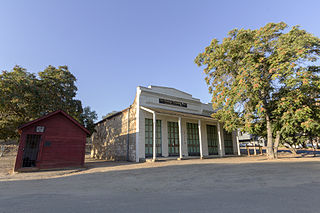
La Grange is a small unincorporated community in rural Stanislaus County, California, United States. Its altitude is 249 feet (76 m). As of 2008 it has a population of 345. It is located at 37°39′49″N120°27′49″W along the Tuolumne River, and is near the La Grange Dam and the New Don Pedro Dam.
The Rural Municipality of Coldwell is located in the Interlake Region of the province of Manitoba in Western Canada.
Warrior Mountain Wildlife Management Area is a Wildlife Management Area in Oldtown, Allegany County, Maryland.

Tragedy Spring is a small alpine freshwater spring and a former settlement in eastern Amador County, California adjacent to Highway 88 approximately two miles west of Silver Lake. It was named after an incident on June 27, 1848, in which three Mormon men were killed adjacent to the spring, allegedly by Native Americans, and their bodies burned and buried. The names of the men were carved on a large tree in this location.

Copper Cove Subdivision is an unincorporated community in Calaveras County, California. It lies at an elevation of 1070 feet.
Claus is a small unincorporated town in Stanislaus County, California, United States on the northeastern outskirts of Modesto; it is also in between Riverbank and Empire. Claus is located at 37°41′12″N120°55′12″W.
The Empire City Historic Landmark is a California Historic Landmark in honor of the pioneer John C. Marvin who from 1850, settled on the south bank of the Tuolumne River and called the town "Empire City". Empire City was the head of navigation for small steamboats that could ascend the Tuolumne River carrying passengers and supplies. It was the shipping point for the large grain crops grown in the area. At its height, the town had three stores, a three-story hotel, two boarding houses, a blacksmith shop, a church, and a school house. Empire City was voted as the county seat of Stanislaus County from October 1854 to December 1855. The town was destroyed by flood waters during the Great Flood of 1862. A new railroad town was built 40 years later 1 mile north of the old town site, taking the name Empire.
Mount Cross is an unincorporated community in Pittsylvania County, in the U.S. state of Virginia.
Toril is a municipality in the province of Cáceres and autonomous community of Extremadura, Spain. The municipality covers an area of 149.76 square kilometres (57.82 sq mi) and as of 2014 had a population of 176 people.

Anvarza Castle is an ancient castle in Adana Province, Turkey.
Lottridge is an unincorporated community in Athens County, Ohio, United States.
Solomons Store is a small unincorporated community in Henrico County, located where Telegraph Road and Mountain Road fork off of U.S. Route 1.

Ravinamy is an unincorporated community in Wabash Township, Tippecanoe County, in the U.S. state of Indiana.
Blay Creek is a stream in St. Francois and Washington counties in the U.S. state of Missouri. It is a tributary of the Big River.


