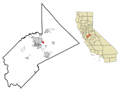
Empire | |
---|---|
Motto: The Mexican City of the Central Valley | |
Coordinates: 37°38′39″N120°54′27″W / 37.64417°N 120.90750°W | |
Country | United States |
State | California |
County | Stanislaus |
Empire City | 1850 |
Empire | 1896 |
Area | |
• Total | 1.563 sq mi (4.049 km2) |
• Land | 1.563 sq mi (4.049 km2) |
• Water | 0 sq mi (0 km2) 0% |
Elevation | 118 ft (36 m) |
Population (2020) | |
• Total | 4,202 |
• Density | 2,700/sq mi (1,000/km2) |
Time zone | UTC-8 (Pacific (PST)) |
• Summer (DST) | UTC-7 (PDT) |
ZIP code | 95319 |
Area code | 209 |
FIPS code | 06-22622 |
GNIS feature ID | 1658501 |
Empire is a census-designated place (CDP) in Stanislaus County, California, United States. The population was 4,189 at the 2010 census, up from 3,903 at the 2000 census. It is part of the Modesto Metropolitan Statistical Area. Influenced by the Mexican culture, Empire is agriculturally active, and is home to the new Empire Community Park.
In 1854, the town of Empire City was founded on the south bank of the Tuolumne River, one mile south of present-day Empire. It was reputedly named after New York City, the "Empire City". However, some sources indicate that the town was founded as early as 1850. The town shows on the 1852 Gibbes map as Empire. It is alleged to have been almost destroyed and deserted twice, in 1852 and 1855. The town served as the head of navigation for steamboats on the Tuolumne River. Empire City became the county seat of Stanislaus County, and was flooded in the Great Flood of 1862. In 1896, the town relocated one mile north of the river, and was renamed Empire for the Santa Fe Railroad. (Part of the San Francisco and San Joaquin Valley Railroad line which the Santa Fe acquired in 1898.)
Downtown Empire is situated in the second town layout. It includes a small post office, a Church of the Brethren church, and the Empire Community Park with the Empire City Historic Landmark.
Empire is located at 37°38′39″N120°54′27″W / 37.64417°N 120.90750°W (37.644298, -120.907592). [2]
According to the United States Census Bureau, the CDP has a total area of 1.6 square miles (4.1 km2), all of it land.
According to the Köppen climate classification system, Empire has a warm-summer Mediterranean climate, Csa on climate maps. [3]
Census | Pop. | Note | %± |
---|---|---|---|
2000 | 3,784 | — | |
2010 | 4,189 | 10.7% | |
2020 | 4,202 | 0.3% | |
U.S. Decennial Census [4] |
The 2010 United States Census [5] reported that Empire had a population of 4,189. The population density was 2,679.5 inhabitants per square mile (1,034.6/km2). The racial makeup of Empire was 2,274 (54.3%) White, 22 (0.5%) African American, 56 (1.3%) Native American, 59 (1.4%) Asian, 8 (0.2%) Pacific Islander, 1,500 (35.8%) from other races, and 270 (6.4%) from two or more races. Hispanic or Latino of any race were 2,275 persons (54.3%).
The Census reported that 4,037 people (96.4% of the population) lived in households, 152 (3.6%) lived in non-institutionalized group quarters, and 0 (0%) were institutionalized.
There were 1,215 households, out of which 570 (46.9%) had children under the age of 18 living in them, 585 (48.1%) were opposite-sex married couples living together, 244 (20.1%) had a female householder with no husband present, 103 (8.5%) had a male householder with no wife present. There were 98 (8.1%) unmarried opposite-sex partnerships, and 11 (0.9%) same-sex married couples or partnerships. 204 households (16.8%) were made up of individuals, and 71 (5.8%) had someone living alone who was 65 years of age or older. The average household size was 3.32. There were 932 families (76.7% of all households); the average family size was 3.74.
The population was spread out, with 1,227 people (29.3%) under the age of 18, 428 people (10.2%) aged 18 to 24, 1,097 people (26.2%) aged 25 to 44, 1,024 people (24.4%) aged 45 to 64, and 413 people (9.9%) who were 65 years of age or older. The median age was 32.8 years. For every 100 females, there were 100.7 males. For every 100 females age 18 and over, there were 96.0 males.
There were 1,328 housing units at an average density of 849.5 units per square mile (328.0 units/km2), of which 724 (59.6%) were owner-occupied, and 491 (40.4%) were occupied by renters. The homeowner vacancy rate was 2.0%; the rental vacancy rate was 10.5%. 2,375 people (56.7% of the population) lived in owner-occupied housing units and 1,662 people (39.7%) lived in rental housing units.
As of the census [6] of 2000, there were 3,903 people, 1,160 households, and 881 families residing in the CDP. The population density was 2,463.7 inhabitants per square mile (951.2/km2). There were 1,214 housing units at an average density of 766.3 units per square mile (295.9 units/km2). The racial makeup of the CDP was 65.92% White, 0.54% African American, 1.46% Native American, 1.82% Asian, 0.20% Pacific Islander, 24.62% from other races, and 5.43% from two or more races. Hispanic or Latino of any race were 42.89% of the population.
There were 1,160 households, out of which 39.0% had children under the age of 18 living with them, 52.6% were married couples living together, 16.3% had a female householder with no husband present, and 24.0% were non-families. 20.6% of all households were made up of individuals, and 9.1% had someone living alone who was 65 years of age or older. The average household size was 3.30 and the average family size was 3.77.
In the CDP, the population was spread out, with 31.6% under the age of 18, 10.3% from 18 to 24, 27.4% from 25 to 44, 19.8% from 45 to 64, and 10.9% who were 65 years of age or older. The median age was 32 years. For every 100 females, there were 95.5 males. For every 100 females age 18 and over, there were 89.5 males.
The median income for a household in the CDP was $27,500, and the median income for a family was $30,862. Males had a median income of $28,814 versus $22,750 for females. The per capita income for the CDP was $12,133. About 16.5% of families and 21.8% of the population were below the poverty line, including 25.1% of those under age 18 and 22.2% of those age 65 or over.
The Empire Municipal Advisory Council is the town's council, along with the library, sheriff's office, and health center, it receives help from Stanislaus County.
In the California State Legislature, Empire is in the 5th Senate District , represented by Democrat Susan Eggman, and in the 12th Assembly District , represented by Democrat Damon Connolly. [7]
In the United States House of Representatives, Empire is in California's 10th congressional district , represented by Democrat Mark DeSaulnier. [8]
Durham is a census-designated place (CDP) in Butte County, California, United States. The population was 5,518 at the 2010 census.
Dustin Acres is a census-designated place (CDP) in Kern County, California, United States. Dustin Acres is located 6.5 miles (10 km) north-northeast of Taft, at an elevation of 384 feet (117 m). The population was 652 at the 2010 census, up from 585 at the 2000 census.
Rosedale is a census-designated place (CDP) in Kern County, California, United States. The population was 14,058 at the 2010 census, up from 8,445 at the 2000 census. Formerly a country town 10 miles (16 km) west of Bakersfield, it is now surrounded by suburban housing and currently has the highest household income in Kern County, according to Census estimates.
West Carson is an unincorporated community in the South Bay region of Los Angeles County, California. The population was 22,870 at the 2020 census. For statistical purposes, the United States Census Bureau has defined West Carson as a census-designated place (CDP).
North Auburn is a census-designated place (CDP) in Placer County, California, United States. It is part of the Sacramento–Arden-Arcade–Roseville Metropolitan Statistical Area. The population was 13,452 at the 2020 census.
Valle Vista is a unincorporated area in Riverside County, California, United States and is located in the San Jacinto Valley. Valle Vista is adjacent to and east of the cities of San Jacinto and Hemet. The population was 11,036 at the 2010 census, up from 8,356 at the 2000 census. For statistical purposes, the United States Census Bureau has defined Valle Vista as a census-designated place (CDP).
Alpine is a census-designated place (CDP) in the Cuyamaca Mountains of San Diego County, California. Alpine had a population of 14,696 at the 2020 census, up from 14,236 at the 2010 census. The town is largely surrounded by the Cleveland National Forest and borders two reservations of the Kumeyaay Nation, Viejas and Sycuan, and the rural unincorporated areas around the city of El Cajon.
Bret Harte is a census-designated place (CDP) in Stanislaus County, California, United States. The population was 5,152 at the 2010 census, down from 5,161 at the 2000 census. It is part of the Modesto Metropolitan Statistical Area. It is named for the American poet and short story writer, Bret Harte, best known for his writings about the California Gold Rush.
Bystrom is a census-designated place (CDP) in Stanislaus County, California, United States. The population was 4,008 at the 2010 census, down from 4,518 at the 2000 census. It is part of the Modesto Metropolitan Statistical Area.
Del Rio is a census-designated place (CDP) in Stanislaus County, California, United States that is located around the Del Rio Country Club. The population was 1,270 at the 2010 census, up from 1,168 at the 2000 census. It is part of the Modesto Metropolitan Statistical Area.
East Oakdale is an unincorporated census-designated place (CDP) on the Stanislaus River, located east of the city of Oakdale in Stanislaus County, California.
Grayson is an unincorporated community in Stanislaus County, California, United States. The population was 952 at the 2010 census, down from 1,077 at the 2000 census. For statistical purposes, the United States Census Bureau has defined Grayson as a census-designated place (CDP). It is part of the Modesto Metropolitan Statistical Area.
Salida is a census-designated place (CDP) in Stanislaus County, California, in the United States. As of the 2010 census, the CDP population was 13,722. It is part of the Modesto Metropolitan Statistical Area. Cultivation of almonds has historically been a significant activity in the vicinity, including a major Blue Diamond processing facility nearby. The plant is involved exclusively in processing whole brown almond kernels with a "dry" process involving no water, heat or chemicals. Salida is within the East Stanislaus Resource Conservation District which comprises 984 square miles (2,550 km2) of land area and attends to a variety of environmental conservation and best management agricultural practices.
Shackelford is a southern neighbourhood of the city of Modesto in Stanislaus County, California, United States, which was officially annexed on June 1, 2012. The population was 3,371 at the 2010 census, down from 5,170 at the 2000 census. It is part of the Modesto Metropolitan Statistical Area. Prior to its annexation, the neighbourhood was a census-designated place (CDP).
Twain Harte is a census-designated place (CDP) in Tuolumne County, California, United States. The population was 2,226 at the 2010 census, down from 2,586 at the 2000 census. Its name is derived from the last names of two famous authors who lived in California, Mark Twain and Bret Harte.
South Highpoint is a census-designated place (CDP) in Pinellas County, Florida, United States. The population was 5,195 at the 2010 census.
Hawaiian Beaches is a census-designated place (CDP) in Hawaiʻi County, Hawaiʻi, United States located in the District of Puna. The population was 4,280 at the 2010 census, up from 3,709 at the 2000 census.
Cherry Grove is a census-designated place (CDP) in Anderson Township, Hamilton County, Ohio, United States. The population was 4,419 at the 2020 census.
Clearwater is a census-designated place (CDP) in Aiken County, South Carolina. It lies near North Augusta, South Carolina, and is part of the Augusta, Georgia metropolitan area. Clearwater is located in historic Horse Creek Valley. The population was 4,370 at the time of the 2010 census.
Crows Landing is a census-designated place (CDP) in Stanislaus County, California. Crows Landing is about 20 miles (32 km) southwest of Modesto. Crows Landing sits at an elevation of 128 feet (39 m). The 2020 United States census reported Crows Landing's population was 322.