Americus is a city in Lyon County, Kansas, United States. As of the 2010 census, the city population was 896.

Emporia is a city in and the county seat of Lyon County, Kansas, United States. As of the 2010 census, the city population was 24,916. Emporia lies between Topeka and Wichita at the intersection of U.S. Route 50 with Interstates 335 and 35 on the Kansas Turnpike. Emporia is also a college town, home to Emporia State University and Flint Hills Technical College.

Reading is a city in Lyon County, Kansas, United States. As of the 2010 census, the city population was 231.

Florence is a city in Marion County, Kansas, United States. The city was named after the daughter of the third Governor of Kansas Samuel J. Crawford. As of the 2010 census, the city population was 465.
Agnes City Township is a township in Lyon County, Kansas, United States.

Area code 785 is the area code for telephone exchanges in most of northern Kansas. It was created in a split of the numbering plan area 913 on July 20, 1997, and stretches from the Colorado state line on the west to the Missouri state line on the east, while excluding the Kansas side of the Kansas City metropolitan area, which retained 913. The largest city by population in the numbering plan area is the Kansas state capital, Topeka.

Area Code 620 covers telephone exchanges in most of southern Kansas. It was created as the result of a split from 316 on February 3, 2001. The area code stretches from the Colorado border to the east, to the Missouri border. It completely surrounds 316, which now only serves Wichita and its inner suburbs. Permissive dialing of 316 across southern Kansas continued until November 3, 2001.
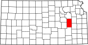
East-Central Kansas is a region of Kansas. Extending roughly from Osage County, Franklin County, and Miami County in the north to Coffey County, Anderson County and Linn County in the south. The eastern border is Missouri. The region then extends westward towards the Flint Hills to Lyon County. The region is rich with Kansas history, as many locations of this region saw battles in Bleeding Kansas. The infamous abolitionist John Brown and his men battled in Osawatomie. The region geographically features rolling hills and deep forested river valleys. The main crop of this predominantly agricultural region is corn. Much of the area is powered by Wolf Creek Nuclear Generating Station which is located near Burlington. The area is more forested and more moist compared to the rest of the state. The most populous cities of this region include:

Bazaar is an unincorporated community in Chase County, Kansas, United States. The community is part of the Emporia Micropolitan Statistical Area.
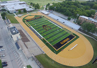
Francis G. Welch Stadium, also known as Jones Field at Welch Stadium or Welch Stadium, is a sport stadium in Emporia, Kansas. The facility is primarily used by the Emporia State University football and track & field teams and Emporia High School football. It is named to honor long-time Emporia State coach and athletic director Fran Welch. The facility was one of the first on the NCAA Division II level to offer enclosed skyboxes and is still one of only a few across the nation.

Cottonwood River is one of the principal tributaries of the Neosho River in central Kansas of the United States.
Plymouth is an unincorporated community in Lyon County, Kansas, in the United States.
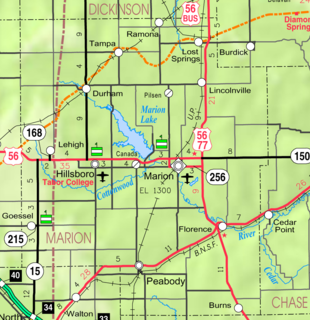
Oursler was an unincorporated community in Marion County, Kansas, United States. It is currently a ghost town that was located approximately 3.5 miles southeast of Marion next to a former railroad. No buildings remain of this former community.
Americus Township is a township in Lyon County, Kansas, United States.
Fremont Township is a township in Lyon County, Kansas, United States.
Ivy Township is a township in Lyon County, Kansas, United States.
Jackson Township is a township in Lyon County, Kansas, United States.
Pike Township is a township in Lyon County, Kansas, United States.
Waterloo Township is a township in Lyon County, Kansas, United States.