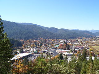
Swansea is a populated place in La Paz County in the U.S. state of Arizona. It was settled around 1909 in what was then the Arizona Territory. It served as a mining town as well as a location for processing and smelting the copper ore taken from the nearby mines.

Kennecott Utah Copper LLC (KUC), a division of Rio Tinto Group, is a mining, smelting, and refining company. Its corporate headquarters are located in South Jordan, Utah, USA. Kennecott operates the Bingham Canyon Mine, one of the largest open-pit copper mines in the world in Bingham Canyon, Salt Lake County, Utah. The company was first formed in 1898 as the Boston Consolidated Mining Company. The current corporation was formed in 1989. The mine and associated smelter produce 1% of the world's copper.

Gilman is an abandoned mining town in southeastern Eagle County, Colorado, United States. The U.S. Post Office at Minturn now serves Gilman postal addresses.
Anyox was a small company-owned mining town in British Columbia, Canada. Today it is a ghost town, abandoned and largely destroyed. It is located on the shores of Granby Bay in coastal Observatory Inlet, about 60 kilometres southwest of Stewart, British Columbia, and about 20 kilometres, across wilderness, east of the tip of the Alaska Panhandle.
Mount Sicker is a small mountain on Vancouver Island, British Columbia, Canada. It is near Crofton, Chemainus and Duncan.

The Indian Valley (IV) Railroad was a shortline railroad that was constructed from the Engels Copper Mine to a connection with the Western Pacific Railroad at Paxton, in Plumas County, northeastern California.

Picacho is an unincorporated community in Imperial County, California. It is located on the Colorado River 29 miles (47 km) south-southeast of Palo Verde, at an elevation of 203 feet.
Louis Davidson Ricketts was an American economic geologist, metallurgist, mining engineer and banker who pioneered development of copper mines in the U.S. state of Arizona and the Mexican state of Sonora.
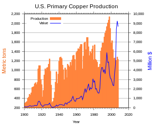
Copper mining in the United States has been a major industry since the rise of the northern Michigan copper district in the 1840s. In 2017 the United States produced 1.27 million metric tonnes of copper, worth $8 billion, making it the world's fourth largest copper producer, after Chile, China, and Peru. Copper was produced from 23 mines in the US. Top copper producing states in 2014 were Arizona, Utah, New Mexico, Nevada, and Montana. Minor production also came from Idaho, and Missouri. As of 2014, the US had 45 million tonnes of known remaining reserves of copper, the fifth largest known copper reserves in the world, after Chile, Australia, Peru, and Mexico.

The Cerro Gordo Mines are a collection of abandoned mines located in the Inyo Mountains, near Lone Pine, California in Inyo County, California. Mining operations were undertaken from 1866 until 1957, producing high grade silver, lead, and zinc ore. Some ore was smelted on site, but larger capacity smelters were eventually constructed along the shore of nearby Owens Lake.
The Burra Burra Mine is a copper mine located in Ducktown, Tennessee, in the southeastern United States. Named for the famous mine in Australia, the Burra Burra Mine extracted over 15 million tons of copper ore during its 60 years of operation between 1899 and 1959. The mine's remaining structures are listed on the National Register of Historic Places as part of the Burra Burra Mine Historic District. The site is also home to the Ducktown Basin Museum, and the museum and mine are a Tennessee State Historic Site operated in partnership with the Tennessee Historical Commission.

Forest City is a ghost town in Utah County, Utah, United States. It is located in the valley of Dutchman Flat in the upper part of American Fork Canyon, in the Uinta National Forest. A silver mining town just over the mountain from Alta, Forest City was inhabited about 1871–1880. The town grew up around the smelter that was built to process ore from the canyon's mines. The American Fork Railroad, which was intended to serve Forest City and the smelter, stopped short of its destination due to engineering difficulties. Transportation costs rose too high for the mines to continue operating profitably. As the smelter, mines, and railroad closed down, Forest City was abandoned.
The Detroit Copper Mining Company was an American copper mining and smelting operation based in Morenci, Arizona. Incorporated in July 1872, it existed as an independent company until 1897, when a controlling interest in the company was purchased by the predecessor of the Phelps Dodge Corporation. It continued to exist as a subsidiary of Phelps Dodge & Co until 1917, when all Phelps Dodge operations in the area were consolidated into the new Phelps Dodge Corporation, Morenci Branch.
The Sacramento Valley and Eastern Railway (SV&E) was a railway company that operated in Shasta County, California, from 1908 to the early 1930s.

Bristol Wells, also known as National City, Bristol City and Tempest, is a ghost town in Lincoln County, Nevada. The mining town was located on the west side of Bristol Mountain, 14 miles (23 km) northwest of Pioche, Nevada.
Poeville, also known as Peavine until 1863, is the site of a historical mining town, established in 1864. John Poe, a professional promoter from Michigan allegedly related to Edgar Allan Poe, discovered rich gold and silver veins in 1862 on the slopes of Peavine Mountain. After the discovery of ore, Poe announced that the veins comprised the next Comstock Lode; he presented extracted ore at the state fair of 1864 as rich in content. As a result, the former mining camp, called Poe City (Poeville) or Podunk (Poedunk), grew to 200 people by 1864. Ore production in the mining district and population peaked around 1873-1874 with several hundred people living in town, supported by three hotels and a post office. The post office, named "Poeville", operated between September 1, 1874, and March 24, 1878.

Twin Buttes is a populated place on the east flank of the Sierrita Mountains about twenty miles south of Tucson, in Pima County, Arizona. Named after a prominent hill located next to the town, Twin Buttes was founded as a small mining town around 1903 and abandoned around 1930. Much of the actual town site is now buried underneath mine tailings, and all that remains is the Twin Buttes Cemetery.

Silver Bell is a populated place located in the Silver Bell Mountains in Pima County, Arizona. The name "Silver Bell" refers to a more recent ghost town, which was established in 1954 and abandoned in the 1970s. The original town, established in 1904, was named "Silverbell" and abandoned in the early 1930s. Both towns were utilized and later abandoned due to the mining of copper in the area.

The Britannia Mines Concentrator is a National Historic Site of Canada. The large, inclined gravity mill was built on the northwest side of Mount Sheer to assist the transfer of copper ore through the chemical and mechanical processes of the plant. It is a landmark in Britannia Beach, British Columbia some forty-five kilometers north of Vancouver.