
The United States Virgin Islands are a group of several dozen islands and cays located in the Caribbean, about 1,100 miles (1,770 km) southeast of Florida, 600 miles (966 km) north of Venezuela, 40 miles (64 km) east of Puerto Rico, and immediately west and south of the British Virgin Islands.
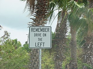
The United States Virgin Islands (USVI) is the only place under United States jurisdiction where the rule of the road is to drive on the left. However, virtually all passenger vehicles are left hand drive due to imports of U.S. vehicles.

The Virgin Islands National Park is an American national park preserving about 60% of the land area of Saint John in the United States Virgin Islands, as well as more than 5,500 acres of adjacent ocean, and nearly all of Hassel Island, just off the Charlotte Amalie, Saint Thomas harbor.

Saint John is one of the Virgin Islands in the Caribbean Sea and a constituent district of the United States Virgin Islands (USVI), an unincorporated territory of the United States.

Cruz Bay, U.S. Virgin Islands is the main town on the island of Saint John in the United States Virgin Islands. According to the 2000 census, Cruz Bay had a population of 2,743.

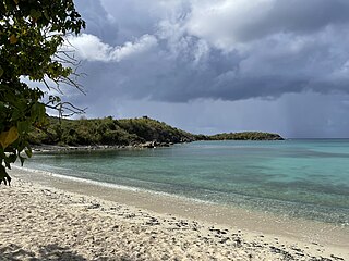
Cinnamon Bay is a body of water and a beach on St. John island, within Virgin Islands National Park, in the United States Virgin Islands.

Red Hook is a town located on the east side of Saint Thomas in the East End subdistrict. Referred to as Red Hook, the East End features an unofficial "town" of red-tiled roof homes and businesses dotting a rolling coastline that overlooks Pillsbury Sound and the island of St. John. Red Hook hosts several hotels, marinas, a busy port, and other key items of the east side of St. Thomas.

Enighed is a settlement on the island of Saint Thomas in the United States Virgin Islands.
Concordia is an area on the island of Saint John in the United States Virgin Islands. It is located on the south east corner of the island, near Salt Pond Bay. Much of the area is part of Virgin Islands National Park. Concordia Eco-Resort is located here.
Fish Bay is a bay and neighborhood on the island of Saint John in the United States Virgin Islands. Most of this area is part of Virgin Islands National Park.

Hermitage is an area of Virgin Islands National Park on the island of Saint John in the United States Virgin Islands. It is located along the north side of Coral Bay, between the town of Coral Bay and the island's inhabited East End. The mangroves of Princess Bay, inside the National Park, are a popular kayaking and snorkeling spot.
Johns Folly is a neighborhood on the island of Saint John in the United States Virgin Islands. It is located on the east side of the island, south of Coral Bay and north of Salt Pond Bay.
Lameshur is a former plantation on the island of Saint John in the United States Virgin Islands. It is inside Virgin Islands National Park and home to the Virgin Islands Environmental Resource Station (VIERS). The Tektite program placed two underwater habitats in Great Lameshur Bay and the Tektite Underwater Habitat Museum is located in the VIERS camp. The road to Lameshur is unmaintained and 4 wheel drive vehicles are often required. The University of the Virgin Islands has a research station and dock in Lameshur on Yawzi Point.
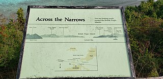
Leinster Bay is a bay and former sugar cane plantation on the island of Saint John in the United States Virgin Islands. It is uninhabited and part of Virgin Islands National Park. Visitors can park at Annaberg and hike the Leinster Bay trail to access the bay, which is a popular snorkeling spot. Waterlemon Cay is a small cay in Leinster Bay. The ruins of the plantation's estate house can be reached by continuing past the bay and up the Johnny Horn Trail.
Mary Point is an uninhabited peninsula on the island of Saint John in the United States Virgin Islands. There are no roads or trails and steep cliffs prevent access from the water. Although Mary Point once housed a small sugar cane plantation, the area is now overgrown with thick forest. The foundation and crumbling walls of Mary Point Estate can be seen from the Francis Bay trail. It is part of Virgin Islands National Park. Mary Creek, the shallow bay on the east side, is a popular spot for fly fishing and kitesurfing.
Mount Pleasant is an area of Virgin Islands National Park on the island of Saint John in the United States Virgin Islands. It is located between Maho Bay and Centerline Road. This area is uninhabited and its name has fallen out of use.
Reef Bay is a neighborhood and bay on the island of Saint John in the United States Virgin Islands. Most of this area is part of Virgin Islands National Park. The inhabited portion is along the west side of Reef Bay, near Fish Bay. The Reef Bay Sugar Factory ruins are located in the center of Reef Bay, in an area known as Genti Bay. The nearly 3 mile long Reef Bay Trail is a National Park Service maintained hiking trail that runs through the area from Centerline Road to Genti Bay.
Sieben is a former plantation on the island of Saint John in the United States Virgin Islands. Homes in this area are considered by the local government to be located in Remainder Fish Bay. The Sieben plantation ruins are accessible via the L'Esperance Trail. Most of this area is part of Virgin Islands National Park. The only baobab tree on St. John is near the Sieben ruins.

U.S. Virgin Islands Governor's Mansion may refer to any one of the three official residences owned by the government of the U.S. Virgin Islands and provided to the Governor of the United States Virgin Islands. One residence is located on each of the three largest inhabited islands of this U.S. territory in the Caribbean. The U.S. Virgin Islands maintains more official gubernatorial residences than any other state or territory of the United States.
