Related Research Articles
The Atlanta Beltline is a 22 miles (35 km) open and planned loop of multi-use trail and light rail transit on a former railway corridor around the core of Atlanta, Georgia. The Atlanta Beltline is designed to reconnect neighborhoods and communities historically divided and marginalized by infrastructure, improve transportation, add green space, promote redevelopment, create and preserve affordable housing, and showcase arts and culture. The project is in varying stages of development, with several mainline and spur trails complete. Since the passage of the More MARTA sales tax in 2016, construction of the light rail streetcar system is overseen by MARTA in close partnership with Atlanta Beltline, Inc.

Poncey–Highland is an intown neighborhood on the east side of Atlanta, Georgia, located south of Virginia–Highland. It is so named because it is near the intersection of east/west Ponce de Leon Avenue and north/southwest North Highland Avenue. This Atlanta neighborhood was established between 1905 and 1930, and is bordered by Druid Hills and Candler Park across Moreland Avenue to the east, the Old Fourth Ward across the BeltLine Eastside Trail to the west, Inman Park across the eastern branch of Freedom Parkway to the south, and Virginia Highland to the north across Ponce de Leon Avenue. The Little Five Points area sits on the border of Poncey–Highland, Inman Park, and Candler Park.

Grove Park is a northwest Atlanta, inside-the-perimeter neighborhood bounded by:
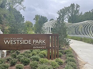
Westside Park at Bellwood Quarry is a park in the City of Atlanta located on the site of the former Bellwood Quarry. The park is between Johnson Road and Donald Lee Hollowell Parkway and between the neighborhoods of Bankhead, Grove Park, and Knight Park/Howell Station, of which a large portion of the park falls within the Grove Park boundaries. Westside Park at Bellwood Quarry was a major green space project of the Atlanta BeltLine master plan. The park has trail connectivity to the Proctor Creek Greenway Trail and will ultimately have connectivity to the BeltLine.
Alexander Garvin was an American urban planner, educator, and author. At the time of his death, he was in private practice at AGA Public Realm Strategists in New York City and was also an adjunct professor at the Yale School of Architecture, where he taught from 1967 on. He is widely known for having created the vision plan of Atlanta's proposed greenbelt park system, the Atlanta BeltLine, serving as planning director for New York City's 2012 Olympic Games bid, and overseeing efforts to redevelop lower Manhattan after the September 11th attacks as Vice President of Planning, Design, and Development for the Lower Manhattan Development Corporation. Garvin also authored a number of books on the subject of planning including The Planning Game: Lessons from Great Cities and The American City: What Works, What Doesn't. Garvin also served in a variety of positions in New York City government including director of comprehensive planning.
The Trust for Public Land is a U.S. nonprofit organization with a mission to "create parks and protect land for people, ensuring healthy, livable communities for generations to come". Since its founding in 1972, the Trust for Public Land has completed 5,000 park-creation and land conservation projects across the United States, protected over 3 million acres, and helped pass more than 500 ballot measures—creating $70 billion in voter-approved public funding for parks and open spaces. The Trust for Public Land also researches and publishes authoritative data about parks, open space, conservation finance, and urban climate change adaptation. Headquartered in San Francisco, the organization is among the largest U.S. conservation nonprofits, with approximately 30 field offices across the U.S., including a federal affairs function in Washington, D.C.

Clear Creek is a stream in northeast Atlanta that is a tributary to Peachtree Creek and part of the Chattahoochee River watershed. It has two main branches, one originating east of the high ground along which Boulevard runs and another to the west originating on the northeast side of downtown Atlanta. The easterly branch of Clear Creek begins in several springs and branches in what are now Inman Park and the Old Fourth Ward. Flowing north, the creek was joined by other branches and springs, including Angier Springs near the end of Belgrade Avenue and the so-called Ponce de Leon Springs, which were “discovered” during railroad construction in the 1860s and gave rise to the eponymous park and avenue.

Capitol View Manor is a small community in Southwest Atlanta that was named for the excellent view of the Georgia State Capitol building. Its boundaries include I-75/85 to the east, the Beltline to the north, Metropolitan Parkway to the west, and Atlanta Technical College to the south.

Westview is a historic intown neighborhood located in southwest Atlanta, Georgia. It is named for the Westview Cemetery that borders the neighborhood to the northwest. The neighborhood is made up of a mixture of architectural styles including Arts & Crafts bungalows, Four-Squares, Tudors, Minimal Traditional houses, and Ranch style houses.

Maddox Park is a 51.5-acre (208,000 m2) community park located in the west side of Atlanta, across Donald Lee Hollowell Parkway from Bankhead MARTA station. It is approximately 1.5 miles (2.4 km) west of Georgia Tech. The park has an existing rail line running through it, which is part of the proposed route of the Belt Line. The park is named in honor of former Atlanta mayor Robert Maddox and opened in 1931.

A linear park is a type of park that is significantly longer than it is wide. These linear parks are strips of public land running along canals, rivers, streams, defensive walls, electrical lines, or highways and shorelines. Examples of linear parks include everything from wildlife corridors to riverways to trails, capturing the broadest sense of the word. Other examples include rail trails, which are disused railroad beds converted for recreational use by removing existing structures. Commonly, these linear parks result from the public and private sectors acting on the dense urban need for open green space. Linear parks stretch through urban areas, coming through as a solution for the lack of space and need for urban greenery. They also effectively connect different neighborhoods in dense urban areas as a result, and create places that are ideal for activities such as jogging or walking. Linear parks may also be categorized as greenways. In Australia, a linear park along the coast is known as a foreshoreway. When being designed, linear parks appear unique as they are planned around the public's opinion of how the space will affect them.
Ormewood Park is a neighborhood on the east side of Atlanta, Georgia, United States.

Capitol View is a historic intown southwest Atlanta, Georgia neighborhood. The neighborhood is 2.5 miles from downtown and was named for its views of the Georgia State Capitol building. Its boundaries include Metropolitan Parkway to the east, Lee Street to the west, and the Beltline to the north. On the south, the border follows Arden Street, Deckner Avenue, and Perkerson Park.
Hunter Hills is a neighborhood located west of downtown Atlanta, Georgia, United States. Its motto, "One Community, One Family", has been its cornerstone since 2001. The neighborhood is encompassed in the 30314 zip code. Hunter Hills shares borders with Mozley Park, Dixie Hills and West Lake neighborhoods. The neighborhood rests just inside Atlanta's perimeter highway I-285, and U.S. Route 78. The schools that serve the neighborhood are Stanton Elementary, Carter G. Woodson Elementary School, Ron Clark Academy, Herndon Elementary and Washington High School, and the Atlanta Job Corps. City of Refuge, a community-based 501(c)(3) non-profit, was established on the 1300 block of Joseph E. Boone Blvd. in 2003 and helps to bring transformation to individuals and families through services including housing, health and wellness, vocational training, and youth development.

Chosewood Park is a neighborhood in southeast Atlanta, Georgia in the United States. It is located south of Peoplestown and Grant Park, west of Boulevard Heights and Benteen Park, northwest of Thomasville Heights and the Atlanta federal penitentiary, and northeast of South Atlanta and Lakewood Heights. It is situated directly on the path of the Atlanta Beltline, which has begun to acquire and develop properties along the rail lines in the Chosewood corridor, including the Boulevard Crossing Park.
Oakland City is a historic neighborhood in southwestern Atlanta, Georgia, United States, just southwest across the BeltLine from West End and Adair Park.

Historic Fourth Ward Park is a park in the Old Fourth Ward of Atlanta, just south of Ponce City Market and just west of the BeltLine Eastside Trail.
Atlanta Georgia includes over 3,000 acres of parkland managed by Parks and Recreation. The 343 Atlanta parks range in scope from formal gardens at Atlanta Botanical Garden to pocket parks in neighborhoods. Additionally, there are six miles of paved pedestrian and bike trails in the Atlanta Beltline as well as the PATH Foundation network of 150 miles of off road trails.

This is the timeline of the development of the BeltLine, a ring of trails and parks around central Atlanta.

Ardmore, sometimes called "Ardmore Park" for the city park of the same name within the neighborhood, is a neighborhood in the extreme south Buckhead area of Atlanta, between Peachtree Road, on the east, railroad tracks and the Atlanta BeltLine on the west, Collier Road to the north and Brookwood to the south. Though distinct from Brookwood and Collier Hills, the neighborhoods are often linked as they share a border and location along Collier Road and Peachtree Street/Road just north of Midtown.
References
- 1 2 "Enota Park". The Trust for Public Land. Retrieved 2018-08-01.
- 1 2 "Westview park gets $600K boost to create Atlanta Beltline link". Curbed Atlanta. Retrieved 2018-08-01.
- ↑ Garvin, Alexander; Schroder, James; Haskell, David (2004). The Beltline Emerald Necklace: Atlanta's New Public Realm (PDF).
- ↑ "Atlanta Beltline Announces Design Firm For Enota Park Expansion | What Now Atlanta". What Now Atlanta. 2018-03-23. Retrieved 2018-08-01.
- 1 2 Tunnel-Spangler-Walsh and Associates, Grice & Associates Inc.; Smith Dalia Architects (2010). Subarea 1 Enota Park Master Plan (PDF).
- ↑ "Public Meeting: Enota Park Design // Atlanta BeltLine". beltline.org. Retrieved 2018-08-01.