
Adwa is a town and separate woreda in Tigray Region, Ethiopia. It is best known as the community closest to the site of the 1896 Battle of Adwa, in which Ethiopian soldiers defeated Italian troops, thus being one of the few African nations to thwart European colonialism. Located in the Central Zone of the Tigray Region, Adwa has a longitude and latitude of 14°10′N38°54′E, and an elevation of 1907 meters. Adwa is surrounded by Adwa woreda.

Dessie is a town in north-central Ethiopia. Located in the South Wollo Zone of the Amhara Region, it sits at a latitude and longitude of 11°8′N39°38′E, with an elevation between 2,470 and 2,550 metres above sea level. Dessie is 400 km to the north of the capital Addis Ababa. It has a population of more than 200,000 people in over 30 wards.
Nekemte, also spelled as Neqemte, is a market town and separate woreda in western Ethiopia. Located in the East Welega Zone of the Oromia Region, Nekemte has a latitude and longitude of 9°5′N36°33′E and an elevation of 2,088 meters.
Debre Markos is a city, separate woreda, and administrative seat of the East Gojjam Zone in Amhara Region, Ethiopia.

Korem is a town and separate woreda in Tigray, Ethiopia. Located on the eastern edge of the Ethiopian highlands in the Debubawi (Southern) Zone of the Tigray Region, this town has a latitude and longitude of 12°30′N39°31′E with an elevation of 2539 meters above sea level and is located along Ethiopian Highway 2. Korem is located in the endoreic basin of the Afar Triangle. The streams near Korem do not reach the ocean. Lake Ashenge is located six kilometers to the north of Korem. The town of Korem is surrounded by Ofla woreda.
Qwara is one of the woredas in the Amhara Region of Ethiopia. Qwara is named after the former province of Qwara, which was in the same area. Located at the westernmost point of the Semien Gondar Zone, Qwara is bordered on the south by the Benishangul-Gumuz Region, on the west by Sudan, on the north by Metemma, on the east by Takusa and Alefa, and on the southeast by Agew Awi Zone; part of its boundary with the Benishangul-Gumaz Region is defined by the Dinder River. The administrative center of this woreda is Gelegu; other settlements include Tewodros Ketema.
Fiche is a town in central Ethiopia. It is the administrative centre of the Kaba Shewa Zone of Oromia and separate District. It is located about three km from the main Addis Ababa-Debre Marqos road, Fiche has a latitude and longitude of 9°48′N38°44′E and an elevation between 2,738 and 2,782 metres above sea level.
Hawzen is a town in northern Ethiopia. Located in the Misraqawi (Eastern) Zone of the Tigray Region, this town has a latitude and longitude of 13°58′N39°26′E with an elevation of 2105 meters above sea level. Its market day is Wednesday. It is the largest settlement in Hawzen woreda.
Ginir is a town in southeastern Ethiopia. Located in the East Bale Zone of the Oromia Region, this town has a latitude and longitude of 7°08′N40°42′E and an elevation between 1750 and 1986 meters above sea level.
Mendi is a town in western Ethiopia. Located in the West Welega Zone of the Oromia Region, this town has a latitude and longitude of 9°36′N35°36′E with an elevation of 1821 meters above sea level.
Bure, also transliterated Burye is a town in western Ethiopia. Located in the Mirab Gojjam Zone of the Amhara Region, this town has a longitude and latitude of 10°42′N37°4′E with an elevation of 2091 meters above sea level.
Selekhlekha(ሰለኽለኻ) is a town in Tigray, Ethiopia. Located in the Semien Mi'irabawi Zone of the Tigray Region, this town has a latitude and longitude of 14°07′N38°29′E with an elevation of 2107 meters above sea level. It is the administrative center of Medebay Zana woreda.
Nedjo is a town in western Ethiopia. Located in the West Welega Zone of the Oromia Region, this town has a latitude and longitude of 9°30′N35°30′E with an elevation of 1821 meters above sea level. It is the administrative center of Nejo woreda. Nejo is served by Nejjo Airport and is 150 km east of Asosa Airport.
Dengel Ber is a town in western Ethiopia. Located on the south-western shore of Lake Tana in the Semien Gondar Zone of the Amhara Region, this town has a latitude and longitude of 11°57′N37°00′E. Access to this town includes track roads to both Shawra and Kunzela and weekly service by the Bahir Dar-Gorgora ferry on Lake Tana. While the name of the town is indisputably Amharic, there is some disagreement over the meaning of its name: while "Pass of the Virgin" has been the most common interpretation since at least the days James Bruce visited Ethiopia, Huntingford and Beckingham state that it means "pass of canna plants".
Gidami is a town in western Ethiopia. Located in the Kelem Welega Zone of the Oromia Region, this town has a latitude and longitude of 08°59′N34°37′E with an elevation between 1776 and 1928 meters above sea level. It is the main town of Gidami woreda.
Hintalo, also called Antalo, was Administrative Center of Enderta’s historical wereda of Gabat Melash, is a small town located in the Debub Misraqawi (Southeastern) Zone of the Tigray Region of Ethiopia. It lies on a plateau with an elevation variously reported as 2050 to 2102 meters above sea level. It lies some 20 miles south of Mekelle, the capital of Tigray. The urge to control this fortified mountainous place has provoked frequent engagements among various Tigrayan chiefs since the 17th century. Hintalo flourished as a town in the last quarter of the 18th and beginning of the 19th century.
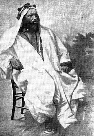
Ras Alula Engida was an Ethiopian general and politician who successfully led Abyssinian battles against Ottoman Egypt, the Mahdists and Italy. He was one of the most important leaders of the Abyssinian forces during the 19th century. Ras Alula Described by Haggai Erlich as the "greatest leader whom Ethiopia produced since the death of Emperor Tewodros II in 1868." Ras Alula was referred to by Europeans as "the Garibaldi of Ethiopia".
Sheno (Shanoo) is a town in central Ethiopia. Located in the Kaba Shewa Zone, Oromia, it has an elevation of 2918 meters above sea level. It is the administrative center of Kembibit Aanaa. The main buildings in the city that can be shown is the new building built by a German philanthropist organization Menschen für Menschen. Older buildings that are serving as school and city administration were the remnants from the Italian camping site during the 5 years stay of the Italians.
Dabat is a town in northern Ethiopia, located about 50 kilometers north of Gondar in the Semien Mountains along the Gondar-Debarq highway Dabat it is in the Semien Gondar Zone of the Amhara Region, and is one of two towns in Dabat woreda.
Hirna a town Located in the West Hararghe Zone Of Oromia, Ethiopia it has a latitude and longitude of 9°13′N41°06′E and an altitude of 1763 meters above sea level. It is the larger of the two towns in Tulo woreda.

