
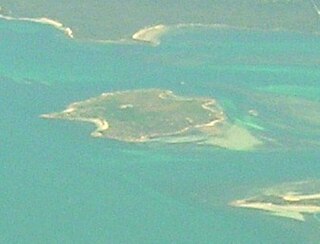
Entrance Island is a low island with an area of 6.1 ha. It lies at the entrance to Macquarie Harbour in Western Tasmania at an area known as Hell's Gates. It contains a light beacon and jetty. [1]
Entrance Island is a low island with an area of 6.1 ha. It lies at the entrance to Macquarie Harbour in Western Tasmania at an area known as Hell's Gates. It contains a light beacon and jetty. [1]
Recorded breeding seabird species are the little penguin (100 pairs) and short-tailed shearwater (1900 pairs). The metallic skink is present. [1]

Hells Gates is the name of the mouth of Macquarie Harbour on the West Coast of Tasmania.

De Witt Island, also known as Big Witch, is an island located close to the south-western coast of Tasmania, Australia. The 516-hectare (1.99 sq mi) island is the largest of the Maatsuyker Islands Group, and comprises part of the Southwest National Park and the Tasmanian Wilderness World Heritage Site. The island is listed on the Australian Register of the National Estate.

Kathleen Island is a steeply cliffed island that lies within Port Davey, an oceanic inlet, located in the south west region of Tasmania, Australia. The island has an area of approximately 11.35 hectares and is contained with the Southwest National Park, part of the Tasmanian Wilderness World Heritage Site and the Port Davey/Bathurst Harbour Marine Nature Reserve.

The Needle Rocks, also known as the Needles, are a group of five main rock islets located close to the south-western coast of Tasmania, Australia. With a combined area of approximately 10.5 hectares (0.041 sq mi), the islets are part of the Maatsuyker Islands Group, and comprise part of the Southwest National Park and the Tasmanian Wilderness World Heritage Site.

Black Pyramid Rock is an island nature reserve, with an area of 40 ha, in Bass Strait, south-eastern Australia. It is part of Tasmania’s Hunter Island Group which lies between north-west Tasmania and King Island. It is part of the Albatross Island and Black Pyramid Rock Important Bird Area. It is notable for its Australasian gannet colony which, at over 12,000 pairs, is the largest in Tasmania and supports about 20% of the world population of the species.
Little Dog Island is a square, flat granite island, with an area of 83 ha, in south-eastern Australia. It is part of Tasmania’s Great Dog Island Group, lying in eastern Bass Strait between Flinders and Cape Barren Islands in the Furneaux Group. It is a game reserve. It was previously grazed, a usage now ceased. The island is part of the Franklin Sound Islands Important Bird Area, identified as such by BirdLife International because it holds over 1% of the world populations of six bird species.
Sloping Island, incorporating the adjacent Sloping Reef, is an island nature reserve, with an area of 117 ha, in Tasmania in south-eastern Australia. It is part of the Sloping Island Group, lying close to the south-eastern coast of Tasmania around the Tasman and Forestier Peninsulas.

The Friars are four steep dolerite rocks, with a combined area of about 17 ha, in south-eastern Australia. They are part of the Actaeon Island Group, lying close to the south-eastern coast of Tasmania, at the southern entrance to the D'Entrecasteaux Channel between Bruny Island and the mainland. They form part of South Bruny National Park.
Hen Island is an island located close to the south-western coast of Tasmania, Australia. The 7.6-hectare (0.029 sq mi) island is part of the Maatsuyker Islands Group, and comprises part of the Southwest National Park and the Tasmanian Wilderness World Heritage Site.

Flat Witch Island, also known as Little Witch Island, is an island located close to the south-western coast of Tasmania, Australia. The 64-hectare (0.25 sq mi) island is part of the Maatsuyker Islands Group, and comprises part of the Southwest National Park and the Tasmanian Wilderness World Heritage Site.
Walker Island is an island located close to the south-western coast of Tasmania, Australia. The 15-hectare (0.058 sq mi) island is part of the Maatsuyker Islands Group, and comprise part of the Southwest National Park and the Tasmanian Wilderness World Heritage Site.
Flat Top Island is an island located close to the south-western coast of Tasmania, Australia. The 1.58-hectare (0.0061 sq mi) island is part of the Maatsuyker Islands Group, and comprises part of the Southwest National Park and the Tasmanian Wilderness World Heritage Site.
Round Top Island is an island located close to the south-western coast of Tasmania, Australia. The 6.25-hectare (0.0241 sq mi) island is part of the Maatsuyker Islands Group, and comprises part of the Southwest National Park and the Tasmanian Wilderness World Heritage Site.

South West Mutton Bird Islet is a dome-shaped unpopulated islet located close to the south-western coast of Tasmania, Australia. Situated some 2 kilometres (1.2 mi) south of where the mouth of Port Davey meets the Southern Ocean, the 0.52-hectare (1.3-acre) islet is one of the eight islands that comprise the Mutton Bird Islands Group. The South West Mutton Bird Islet is part of the Southwest National Park and the Tasmanian Wilderness World Heritage Site.
Wendar Island comprises a main unpopulated island and five immediately adjacent islets located close to the south-western coast of Tasmania, Australia. Situated some 2 kilometres (1.2 mi) south of where the mouth of Port Davey meets the Southern Ocean, the 5.8-hectare (14-acre) island and islets are one of the eight islands that comprise the Mutton Bird Islands Group. The Mutton Bird Island is part of the Southwest National Park and the Tasmanian Wilderness World Heritage Site.
Swainson Island is an unpopulated island with an adjacent islet, located close to the south-western coast of Tasmania, Australia. Situated near where the mouth of Port Davey meets the Southern Ocean, the 4.14-hectare (10.2-acre) island is part of the Swainson Islands Group, and comprises part of the Southwest National Park and the Tasmanian Wilderness World Heritage Site.
Montgomery Rocks comprises a pair of rocky dolerite and limestone islets, with a combined area of 3.69 ha and a high point of 50 m, part of the Hibbs Pyramid Group, lying close to the central western coast of Tasmania.
Leelinger Island is a flat dolerite island with an area of 1.54 ha in south-eastern Australia. It is part of the Hibbs Pyramid Group, lying close to the central western coast of Tasmania.

Bonnet Island is a low island with an area of 2.21 ha. It lies at the entrance to Macquarie Harbour in Western Tasmania Australia, in the vicinity of Hells Gates. Due to its location and proximity to the entrance, it was involved as part the Macquarie Harbour Breakwater construction.

The Port Davey Islands Important Bird Area comprises over 20 small, rocky islands scattered both within, and in the vicinity of, the mouth of Port Davey, an inlet on the south-west coast of Tasmania, Australia. They all lie within the Southwest National Park and are important for breeding seabirds.
Coordinates: 42°12′S145°12′E / 42.200°S 145.200°E
| | This Tasmania geography article is a stub. You can help Wikipedia by expanding it. |