
A wetland is a distinct ecosystem that is flooded or saturated by water, either permanently for years or decades or seasonally for a shorter periods. Flooding results in oxygen-free anoxic processes prevailing, especially in the soils. The primary factor that distinguishes wetlands from terrestrial land forms or water bodies is the characteristic vegetation of aquatic plants, adapted to the unique anoxic hydric soils. Wetlands are considered among the most biologically diverse of all ecosystems, serving as home to a wide range of plant and animal species. Methods for assessing wetland functions, wetland ecological health, and general wetland condition have been developed for many regions of the world. These methods have contributed to wetland conservation partly by raising public awareness of the functions some wetlands provide. Constructed wetlands are designed and built to treat municipal and industrial wastewater as well as to divert stormwater runoff. Constructed wetlands may also play a role in water-sensitive urban design.

Isotope analysis is the identification of isotopic signature, abundance of certain stable isotopes of chemical elements within organic and inorganic compounds. Isotopic analysis can be used to understand the flow of energy through a food web, to reconstruct past environmental and climatic conditions, to investigate human and animal diets, for food authentification, and a variety of other physical, geological, palaeontological and chemical processes. Stable isotope ratios are measured using mass spectrometry, which separates the different isotopes of an element on the basis of their mass-to-charge ratio.

Remote sensing is the acquisition of information about an object or phenomenon without making physical contact with the object, in contrast to in situ or on-site observation. The term is applied especially to acquiring information about Earth and other planets. Remote sensing is used in numerous fields, including geophysics, geography, land surveying and most Earth science disciplines. It also has military, intelligence, commercial, economic, planning, and humanitarian applications, among others.

Landscape ecology is the science of studying and improving relationships between ecological processes in the environment and particular ecosystems. This is done within a variety of landscape scales, development spatial patterns, and organizational levels of research and policy. Concisely, landscape ecology can be described as the science of "landscape diversity" as the synergetic result of biodiversity and geodiversity.

Urban ecology is the scientific study of the relation of living organisms with each other and their surroundings in an urban environment. An urban environment refers to environments dominated by high-density residential and commercial buildings, paved surfaces, and other urban-related factors that create a unique landscape. The goal of urban ecology is to achieve a balance between human culture and the natural environment.
Water quality refers to the chemical, physical, and biological characteristics of water based on the standards of its usage. It is most frequently used by reference to a set of standards against which compliance, generally achieved through treatment of the water, can be assessed. The most common standards used to monitor and assess water quality convey the health of ecosystems, safety of human contact, extent of water pollution and condition of drinking water. Water quality has a significant impact on water supply and oftentimes determines supply options.

A bioindicator is any species or group of species whose function, population, or status can reveal the qualitative status of the environment. The most common indicator species are animals. For example, copepods and other small water crustaceans that are present in many water bodies can be monitored for changes that may indicate a problem within their ecosystem. Bioindicators can tell us about the cumulative effects of different pollutants in the ecosystem and about how long a problem may have been present, which physical and chemical testing cannot.
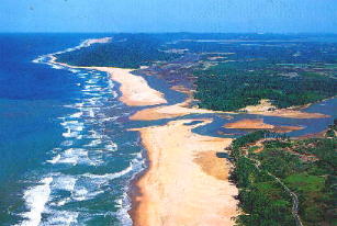
An aquatic ecosystem is an ecosystem found in and around a body of water, in contrast to land-based terrestrial ecosystems. Aquatic ecosystems contain communities of organisms—aquatic life—that are dependent on each other and on their environment. The two main types of aquatic ecosystems are marine ecosystems and freshwater ecosystems. Freshwater ecosystems may be lentic ; lotic ; and wetlands.

Aquatic biomonitoring is the science of inferring the ecological condition of rivers, lakes, streams, and wetlands by examining the organisms that live there. While aquatic biomonitoring is the most common form of biomonitoring, any ecosystem can be studied in this manner.

The normalized difference vegetation index (NDVI) is a widely-used metric for quantifying the health and density of vegetation using sensor data. It is calculated from spectrometric data at two specific bands: red and near-infrared. The spectrometric data is usually sourced from remote sensors, such as satellites.

Paleolimnology is a scientific sub-discipline closely related to both limnology and paleoecology. Paleolimnological studies focus on reconstructing the past environments of inland waters using the geologic record, especially with regard to events such as climatic change, eutrophication, acidification, and internal ontogenic processes.
Geobotanical prospecting refers to prospecting based on the composition and health of surrounding botanical life to identify potential resource deposits. Using a variety of techniques, including indicator plant identification, remote sensing and determining the physical and chemical condition of the botanical life in the area, geobotanical prospecting can be used to discover different minerals. This process has clear advantages and benefits, such as being relatively non-invasive and cost efficient. However, the efficacy of this method is not without question. There is evidence that this form of prospecting is a valid scientific method, especially when used in conjunction with other prospecting methods. But as identification of commercial mines are invariably guided by geological principles and confirmed by chemical assays, it is unclear as to whether this prospecting method is a valid standalone scientific method or an outdated method of the past.
An index of biological integrity (IBI), also called an index of biotic integrity, is a scientific tool typically used to identify and classify water pollution problems, although there have been some efforts to apply the idea to terrestrial environments. An IBI associates anthropogenic influences on a water body with biological activity in the water body, and is formulated using data developed from biosurveys. Biological integrity is associated with how "pristine" an environment is and its function relative to the potential or original state of an ecosystem before human alterations were imposed. Biological integrity is built on the assumption that a decline in the values of an ecosystem's functions are primarily caused by human activity or alterations. The more an environment and its original processes are altered, then by definition, the less biological integrity it holds for the community as a whole. If these processes were to change over time naturally, without human influence, the integrity of the ecosystem would remain intact. Similar to the concept of ecosystem health, the integrity of the ecosystem relies heavily on the processes that occur within it because those determine which organisms can inhabit an area and the complexities of their interactions. Deciding which of the many possible states or conditions of an ecosystem is appropriate or desirable is a political or policy decision.
Environmental monitoring describes the processes and activities that need to take place to characterize and monitor the quality of the environment. Environmental monitoring is used in the preparation of environmental impact assessments, as well as in many circumstances in which human activities carry a risk of harmful effects on the natural environment. All monitoring strategies and programs have reasons and justifications which are often designed to establish the current status of an environment or to establish trends in environmental parameters. In all cases, the results of monitoring will be reviewed, analyzed statistically, and published. The design of a monitoring program must therefore have regard to the final use of the data before monitoring starts.
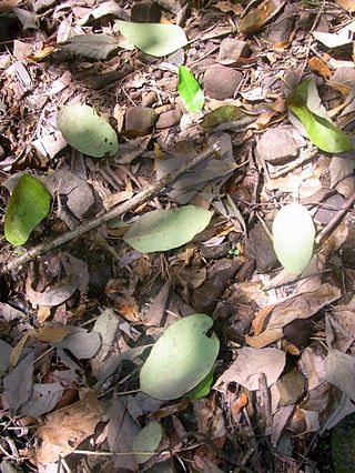
Plant litter is dead plant material that have fallen to the ground. This detritus or dead organic material and its constituent nutrients are added to the top layer of soil, commonly known as the litter layer or O horizon. Litter is an important factor in ecosystem dynamics, as it is indicative of ecological productivity and may be useful in predicting regional nutrient cycling and soil fertility.

Environmental DNA or eDNA is DNA that is collected from a variety of environmental samples such as soil, seawater, snow or air, rather than directly sampled from an individual organism. As various organisms interact with the environment, DNA is expelled and accumulates in their surroundings from various sources. Such eDNA can be sequenced by environmental omics to reveal facts about the species that are present in an ecosystem — even microscopic ones not otherwise apparent or detectable.

Ecosystem Functional Type (EFT) is an ecological concept to characterize ecosystem functioning. Ecosystem Functional Types are defined as groups of ecosystems or patches of the land surface that share similar dynamics of matter and energy exchanges between the biota and the physical environment. The EFT concept is analogous to the Plant Functional Types (PFTs) concept, but defined at a higher level of the biological organization. As plant species can be grouped according to common functional characteristics, ecosystems can be grouped according to their common functional behavior.
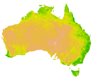
A vegetation index (VI) is a spectral imaging transformation of two or more image bands designed to enhance the contribution of vegetation properties and allow reliable spatial and temporal inter-comparisons of terrestrial photosynthetic activity and canopy structural variations.

DNA barcoding methods for fish are used to identify groups of fish based on DNA sequences within selected regions of a genome. These methods can be used to study fish, as genetic material, in the form of environmental DNA (eDNA) or cells, is freely diffused in the water. This allows researchers to identify which species are present in a body of water by collecting a water sample, extracting DNA from the sample and isolating DNA sequences that are specific for the species of interest. Barcoding methods can also be used for biomonitoring and food safety validation, animal diet assessment, assessment of food webs and species distribution, and for detection of invasive species.
Land cover maps are tools that provide vital information about the Earth's land use and cover patterns. They aid policy development, urban planning, and forest and agricultural monitoring.

