Ephraim Bluff

Last updated
Location of Greenwich Island in the South Shetland Islands. Greenwich-Island-location-map.png
Location of Greenwich Island in the South Shetland Islands.
Ephraim Bluff (in the centre) from near Camp Academia, with Half Moon Island and McFarlane Strait in the foreground. Greenwich.jpg
Ephraim Bluff (in the centre) from near Camp Academia, with Half Moon Island and McFarlane Strait in the foreground.
Topographic map of Livingston Island, Greenwich, Robert, Snow and Smith Islands. Livingston-Island-Map-2010.jpg
Topographic map of Livingston Island, Greenwich, Robert, Snow and Smith Islands.

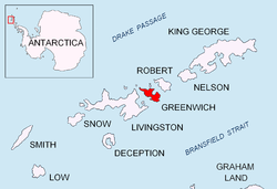
Ephraim Bluff is a 425 m ice-free bluff in the south of Breznik Heights, Greenwich Island in the South Shetland Islands, Antarctica. The bluff is linked to Razgrad Peak to the north-northeast and separates the termini of Wulfila Glacier to the northwest and Zheravna Glacier to the east. It surmounts Doris Cove on the northwest.

Contents

The feature was charted and named 'Mount Ephraim' as early as 1820-22 by American sealers who used it as a lead mark for the nearby Yankee Harbour.

Location

The coastal point formed by the bluff is located at 62°33′24.2″S59°43′14.5″W / 62.556722°S 59.720694°W / -62.556722; -59.720694 which is 3.3 km west by north of Sartorius Point, 7.31 km northeast of Renier Point, Livingston Island and 7.44 km southeast of Triangle Point. British mapping in 1821, 1935 and 1968, Argentine in 1948, Chilean in 1974, and Bulgarian in 2005 and 2009.

Maps

Related Research Articles

<span class="mw-page-title-main">Magura Glacier</span> Glacier in Antarctica

Magura Glacier on the southeast side of Tangra Mountains on Livingston Island in the South Shetland Islands, Antarctica is located to the north of M'Kean Point, northeast of Srebarna Glacier, south of Iskar Glacier and southwest of Dobrudzha Glacier. It is bounded by Great Needle Peak to the west, Vitosha Saddle, Vihren Peak and Helmet Peak to the northwest, Plovdiv Peak and Shishman Peak to the north, and Devin Saddle and Kuber Peak to the northeast. The glacier extends 3.5 km in southwest-northeast direction and 1.9 km in northwest-southeast direction, and flows southeastward into Bransfield Strait.

<span class="mw-page-title-main">Murgash Glacier</span> Glacier in Antarctica

Murgash Glacier is the 3.4 km long and 3.2 km wide glacier on Greenwich Island in the South Shetland Islands, Antarctica situated southeast of Yakoruda Glacier, south of Teteven Glacier, southwest of Traub Glacier and west-northwest of Bravo Glacier. It is bounded by Lloyd Hill on the northwest, Tile Ridge on the east and Hebrizelm Hill on the southeast, and drains southwards into Kramolin Cove in McFarlane Strait between Yovkov Point and Kaspichan Point.

<span class="mw-page-title-main">Musala Glacier</span> Glacier located in Antarctica

Musala Glacier on Greenwich Island in the South Shetland Islands, Antarctica is situated northeast of Targovishte Glacier, east-northeast of Zheravna Glacier and southeast of Fuerza Aérea Glacier. It is bounded by St. Kiprian Peak to the south, Vratsa Peak to the southwest, central Breznik Heights to the west, and Ilarion Ridge bordering Hardy Cove to the northeast, extends 2 nautical miles in east-west direction and 1.2 nautical miles in north-south direction, and drains eastwards into Bransfield Strait north of Fort Point.

<span class="mw-page-title-main">Oborishte Ridge</span> Ridge in the South Shetland Islands, Antarctica

Oborishte Ridge has an elevation of 340 m in the southwest extremity of Breznik Heights, Greenwich Island in the South Shetland Islands, Antarctica. Extending 1.7 km along the southeast coast of Yankee Harbour and 950 m wide. Ice-free surface area 138 hectares. It surmounts Solis Glacier on the east and Wulfila Glacier on the southeast, and Yankee Harbour on the north and Doris Cove on the south.

<span class="mw-page-title-main">Pautalia Glacier</span> Glacier in Antarctica

Pautalia Glacier is a small glacier on Burgas Peninsula, Livingston Island in the South Shetland Islands, Antarctica situated northeast of Strandzha Glacier and south of Sopot Ice Piedmont. It is bounded by Petko Voyvoda Peak to the west, Sozopol Gap to the northwest, Kaloyan Nunatak to the north and Shabla Knoll to the east. The glacier extends 700 m in northwest-southeast direction and 1.1 km in southwest-northeast direction, and flows southeastward into Bransfield Strait.

<span class="mw-page-title-main">Rose Valley Glacier</span> Glacier in Antarctica

Rose Valley Glacier is a glacier on Varna Peninsula, eastern Livingston Island in the South Shetland Islands, Antarctica situated northeast of Saedinenie Snowfield, northwest of Debelt Glacier and north of Panega Glacier. It extends 5.2 km in southeast-northwest direction and 3.7 km in southwest-northeast direction, and drains the northeast slopes of Vidin Heights to flow into Lister Cove and McFarlane Strait between Pomorie Point and Inott Point.

<span class="mw-page-title-main">Srebarna Glacier</span> Glacier in Antarctica

Srebarna Glacier on Livingston Island in the South Shetland Islands, Antarctica is situated east-northeast of Boyana Glacier, southeast of the head of Macy Glacier and southwest of Magura Glacier. It extends 2.3 km in southwest-northeast direction and 1.8 km in northwest-southeast direction, and drains southeast of Serdica Peak and the Great Needle Peak in Levski Ridge, Tangra Mountains to enter Bransfield Strait between Aytos Point and M'Kean Point.

<span class="mw-page-title-main">Strandzha Glacier</span> Glacier in Antarctica

Strandzha Glacier is located on Burgas Peninsula, eastern Livingston Island in the South Shetland Islands, Antarctica northeast of Ropotamo Glacier, south of Sopot Ice Piedmont and southwest of Pautalia Glacier. It is bounded by Delchev Peak to the west, Spartacus Peak, Trigrad Gap and Yavorov Peak to the northwest, and by Elena Peak to the north, extends 1.6 km in northeast-southwest direction and 800 m in northwest-southeast direction, and flows southeastward into Bransfield Strait.

<span class="mw-page-title-main">Targovishte Glacier</span> Glacier in Antarctica

Targovishte Glacier is situated in Breznik Heights on Greenwich Island in the South Shetland Islands, Antarctica, east of Zheravna Glacier and southwest of Musala Glacier. It is bounded by Viskyar Ridge to the west, Vratsa Peak to the northeast, and Drangov Peak and Ziezi Peak to the east, extending 700 m in east-west direction and 1.6 km in north-south direction, and draining southwards into Bransfield Strait northeast of Sartorius Point.

<span class="mw-page-title-main">Terter Peak</span> Ice-covered peak in the South Shetland Islands, Antarctica

Terter Peak is an ice-covered peak rising to 570 m in Breznik Heights, Greenwich Island in the South Shetland Islands, Antarctica surmounting Wulfila Glacier to the southwest, Solis Glacier to the northwest and Zheravna Glacier to the southeast.

<span class="mw-page-title-main">Wulfila Glacier</span> Glacier in Antarctica

Wulfila Glacier is located on the southern slopes of Breznik Heights, Greenwich Island in the South Shetland Islands, Antarctica, south-southwest of Solis Glacier and west of Zheravna Glacier. It is bounded by Oborishte Ridge to the northwest, Nevlya Peak to the north, Terter Peak and Razgrad Peak to the northeast, and Ephraim Bluff to the southeast. The glacier extends 3 km in northwest–southeast direction and 2 km in northeast–southwest direction. It drains southwestwards into McFarlane Strait between Ephraim Bluff and the base of Provadiya Hook, feeding the head of Doris Cove.

<span class="mw-page-title-main">Zheravna Glacier</span> Glacier in Antarctica

Zheravna Glacier is a glacier on Greenwich Island, Antarctica situated east of Wulfila Glacier and west of Targovishte Glacier. It is bounded by Razgrad Peak to the west, Ilinden Peak and Momchil Peak to the north, and Viskyar Ridge to the east, extending 2 km in the east–west direction and 1.8 km in the north–south direction, and draining southwards into McFarlane Strait between Ephraim Bluff and Sartorius Point.

<span class="mw-page-title-main">Maystora Peak</span>

Maystora Peak is a rocky peak rising to 350 m in Breznik Heights on Greenwich Island, Antarctica. Situated 580 m east of Razgrad Peak, 940 m south by west of Ilinden Peak, 2.13 km west of Viskyar Ridge, and 1.38 km northeast of the highest point of Ephraim Bluff. Overlooking Zheravna Glacier to the north, east, and south. Bulgarian topographic survey Tangra 2004/05. Named after the famous Bulgarian artist Vladimir Dimitrov – ‘Maystora’ (1882-1960).

<span class="mw-page-title-main">Sartorius Point</span> Point in the South Shetland Islands, Antarctica

Sartorius Point is a sharp ice-free tipped point formed by an offshoot of Viskyar Ridge and marking the south extremity of Greenwich Island in the South Shetland Islands, Antarctica. The point separates the termini of Zheravna Glacier to the west and Targovishte Glacier to the east. The area was visited by early 19th century sealers.

<span class="mw-page-title-main">Triangle Point</span> Geographic point in Antarctica

Triangle Point is the low ice-free tipped point forming the northwest side of the entrance to Shopski Cove in the south coast of Parvomay Neck linking the northwest and southeast parts of Greenwich Island in the South Shetland Islands, Antarctica. The area was frequented by early 19th century sealers operating from Yankee Harbour.

<span class="mw-page-title-main">Menguante Cove</span> Embayment in the South Shetland Islands, Antarctica

Menguante Cove is a 1.47 km wide embayment indenting for 1.22 km the east coast of the horseshoe-shaped Half Moon Island in the South Shetland Islands, Antarctica. The area was visited by early 19th century sealers operating from nearby Yankee Harbour, and later by whalers; a whaling dory lies on the main landing beach on the southeast coast of the cove. Nowadays Menguante Cove is frequented by Antarctic cruise ships.

<span class="mw-page-title-main">Solis Glacier</span> Glacier in Antarctica

Solis Glacier is a glacier on Greenwich Island in the South Shetland Islands, Antarctica extending 2.8 km in southeast-northwest direction and 1.8 km in southwest-northeast direction and draining the north slopes of Breznik Heights to flow northwestwards into Yankee Harbour.

<span class="mw-page-title-main">Traub Glacier</span> Glacier in Antarctica

Traub Glacier is a glacier on Greenwich Island in the South Shetland Islands, Antarctica extending 2.5 km in northwest-southeast direction and 4 km in southwest-northeast direction and draining the east slopes of Dryanovo Heights to flow eastwards into Discovery Bay.

<span class="mw-page-title-main">Xenia Hill</span> Rocky hill in the South Shetland Islands, Antarctica

Xenia Hill is the rocky hill rising to 96 m in the northeast extremity of Half Moon Island in the South Shetland Islands, Antarctica. It surmounts McFarlane Strait to the north and east, and Menguante Cove to the south-southeast. The area was visited by early 19th century sealers operating from nearby Yankee Harbour.

<span class="mw-page-title-main">Mihaylovski Cove</span> Cove of Livingston Island, South Shetland Islands

Mihaylovski Cove is the 5 km wide cove indenting for 1.3 km the northwest coast of South Bay in Livingston Island, Antarctica that is entered west of Ereby Point and east of Lukovo Point, and has its head fed by Kamchiya Glacier. The area was known to early 19th century sealers who operated from nearby Johnsons Dock. The feature is named after the brothers Petar Mihaylovski, physician at St. Kliment Ohridski base during the 2007/08 and subsequent seasons, and Hristo Mihaylovski, engineer in the national Antarctic campaign during 2015/16 and subsequent seasons.

References