History
Formation
Dr. Arthur Drevar, a graduate of London School of Surgery and a world traveler, bought a parcel of land on the west shore of the Severn River in 1874. Dr. Drevar built a frame house on the hill overlooking the old beach area until such a time as he could build a manor house. However, Mrs. Drevor became ill and lost her eyesight; the English Manor was never built. The area was beautifully kept. The huge boxwood trees and planted shrubbery and flowers, with terraces down to the sandy beach, made a beautiful spot. A barn was built and a pump was used to water the animals as the water was not fit for human consumption. The Doctor kept ducks and peacocks. Bees were kept on the site of the Tea House. Sheep roamed over Sheeps Hill now called Broadlee Trail.
In 1926 Severn Shores, Inc. bought the entire tract of land from the end of the county-owned Epping Forest road down the two inlets, Clements Bay and Salt Pan Bay. In view of the proximity of Epping Forest to Sherwood Forest in England, and the fact that the two summer places would be near one another, it was decided to call this one Epping Forest. [2] The land was surveyed, the lots, roads, parks, lanes and paths indicated and the plat filed with the county court. The spring of 1926, Epping Forest was opened to the public for the sale of lots and was appropriately advertised in newspapers.
In the early days, access to Epping Forest was not easy. Defense Highway did not open to the public until December 1927. Also, while General's Highway from Carr's Corner (now the Annapolis Mall) to the entrance of Epping Forest was under construction, it was necessary to drive to the top of "Bean Hill" to avoid being bogged down. In spite of reasonable precautions, it was often necessary to be towed out by truck, a team of horses or even a yoke of oxen. [1]
Early developments
The early cottagers and owners endured many inconveniences – candles and kerosene lamps for lighting; primitive methods of cooking, even to the iron pot in the fireplace, water either carried from home or from one of the few drilled wells: chemical toilets or the small buildings outside. In order to provide refreshments for the prospective buyers, "Ye English Inn" was built. A dinner for $1.00 was advertised in the newspapers and proved to be a very satisfactory and well cooked meal of fried fish, fried chicken, choice of three vegetables, salad, bread and butter, ice cream, cake and coffee, and was a real drawing card. The bathing beach with bath-house was on the shore of Epping Park and was used exclusively until 1928. Free fish fries and free oyster roasts were given by the company to entice people to visit the Forest. These events were held on the picnic grounds. It was here that all community meetings were held. [1]
April 1927 was the first anniversary and a large fish fry and flower festival was held. People for miles around came to see the display. By 1927 the question of making Epping Forest a closed community was raised. A meeting was held on the picnic grounds at which it was decided to establish the Epping Forest Club, with dues and restrictions in further deeds to show that buyers agreed to become members of the club with obligation for dues for such membership. On December 12, 1927, in compliance with the action taken October 23 at the big oyster roast on the picnic ground at Epping Forest, a meeting of property owners was held in the Washington office of Severn Shores, Inc., and an association was formed to be known as Epping Forest Club. At this meeting, officers and the Board of Governors were elected, and a copy of the proposed By-Laws was presented and approved. The Board of Governors held a meeting January 3, 1928, and ordered the constitution and By-Laws printed and a copy sent to each property owner. Severn Shores, Inc. deeded to Epping Forest Club all parks, paths, lanes and a parcel of land on which to build a clubhouse as well as a number of lots to be sold to finance road construction. By 1928, there were 55 houses with more under construction. Prompt action was taken to expedite the building of the club house and pier. They were completed and officially dedicated on the final day of a three-day Labor Day celebration, September 3, 1928. The furnishings consisted of settees, easy chairs, tables, wall hangings and other necessary articles, resulting in an attractive setting. Kerosene lamps furnished illumination. [1]
1930s
By 1930 there were 98 cottages. A franchise was given by the Epping Forest Club to the Annapolis and Chesapeake Bay Company, April 22, 1930, for supplying electricity to the Forest. Poles were erected in May of that year. Rural Free Delivery service was started in May 1931, as a summer route. This meant deliveries were made from May 16 to September 15 each year and delivery was available from the watchman's gate to the clubhouse and the area in between. Regular daily delivery throughout the whole year was inaugurated in 1939, and about six years later an extension was made to include several other roads within the Forest. [1]
The year 1934 found Epping Forest in a state of complete confusion and deterioration. Roads had become practically impassable; the clubhouse was in deplorable condition, and the pier had washed away after the Northeast storm of August 1933. There was no curb on visitors. The circle was overgrown. Parks, playgrounds and beaches were ragged and the membership did not seem to care what happened to one of the finest summer colonies on the Severn. A small group was spurred to action. They campaigned with a fine program of rehabilitation. They went to the annual meeting in 1934, and a new slate swept into office. The new board of Governors functioned as a team and won the approval and cooperation of the membership. Out of this organization came great results. A newspaper was regularly printed each month; a new pier was built; $1,000 was spent to repair the roads the first year, and $1,500 the second year; all out of dues. The clubhouse was remodeled and renovated; beaches, parks and playgrounds were cleaned up; the circle neatly trimmed and attractively planted; back dues were collected, and current members gladly paid promptly. [1]
Recent developments
The Boat Club built a fine new boathouse for equipment and gear. New capital improvements made in the late 1970s and early 1980s were two tennis courts near the clubhouse, a 10,000-gallon water storage tank for fire protection buried under the circle, and a paved bus turn-around at the gate. The clubhouse, beach area, boat facilities, waterworks, roads and chapel were improved. The Garden Club did extensive landscaping of community areas, including Drevar Park. 1980s: This decade saw major changes in Epping Forest as well as in the adjoining area along Epping Forest Road. New communities sprang up. From General's Highway to the Gate House Epping Forest Road was widened and straightened and some sidewalks were added. A traffic light was installed at Route 178. The entrance to Epping Forest, its roads and clubhouse were improved, and street signs were installed. Cable television was made available to the residents. The value of property in the Forest skyrocketed and houses were built on every available lot. Over the years the social life of the community has continued to evolve: Christmas Eve pageants at the chapel, Easter egg hunts, Halloween parties, swimming meets, end of school parties, and Young Foresters Organization (YFO) programs for the children, bowling leagues, tennis and volleyball tournaments, boat rendezvous and dock parties, welcome aboard parties, and May Marts, all in addition to the established customs of the oyster roast, bull roast and Labor Day activities. [1] [3] [4] [5]

The Lane Cove River, a northern tributary of the Parramatta River, is a tide-dominated, drowned valley estuary west of Sydney Harbour, located in Sydney, New South Wales, Australia. The river is a tributary of the Parramatta River, winding through a bushland valley. It joins Parramatta River at Greenwich and Woolwich, where together they form an arm of Sydney Harbour, and serves as a border along with Middle Harbour separating Sydney's North Shore.
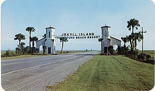
Jekyll Island is located off the coast of the U.S. state of Georgia, in Glynn County. It is one of the Sea Islands and one of the Golden Isles of Georgia barrier islands. The island is owned by the State of Georgia and run by a self-sustaining, self-governing body.

The Oleta River State Park is a 1,043-acre (422 ha) state park on Biscayne Bay in the municipal suburb of North Miami in metropolitan Miami, Florida. Adjoining the Biscayne Bay Campus of Florida International University, the park contains one of the largest concentrations of Casuarina trees, an invasive species in the state park system.

The Conecuh National Forest in southern Alabama covers 83,000 acres (340 km2), along the Alabama - Florida line in Covington and Escambia counties. Topography is level to moderately sloping, broad ridges with stream terraces and broad floodplains.
Packanack Lake is an unincorporated lake community in Wayne in Passaic County, New Jersey, United States. The community is located 30 minutes northwest of Manhattan.

Indian Lake is a reservoir and unincorporated community situated 505 feet above sea level in Denville Township, New Jersey. Snake Hill rises 780 feet (238 m) to its west and Chestnut Hill rises 640 feet (195 m) to its east.

The Eastern Shore is a region of the Canadian province of Nova Scotia. It is the Atlantic coast running northeast from Halifax Harbour to the eastern end of the peninsula at the Strait of Canso.
Chemeketa Park is an unincorporated community of approximately 150 homes located in Lexington Hills, in the Santa Cruz Mountains in Santa Clara County, California, that is now effectively a rural neighborhood of Los Gatos, California. The postal designation for Chemeketa Park is "Los Gatos 95033", although it lies approximately five miles South of the official boundaries of the incorporated town of Los Gatos. The community is in area codes 408 and 669.
The South Shore Cultural Center, in Chicago, Illinois, is a cultural facility located at 71st Street and South Shore Drive, in the city's South Shore neighborhood. It encompasses the grounds of the former South Shore Country Club.

Miracle Beach Provincial Park is a provincial park on the eastern shore of Vancouver Island in British Columbia, Canada. Located between Comox and Campbell River, the park includes a foreshore area in the Strait of Georgia, much of the Black Creek estuary, and a forested area. According to its Master Plan, it fulfills primarily a recreational role with a focus on beach play, picnicking, nature appreciation, and camping, and a secondary conservation role with a focus on the natural shoreline and estuary. I support of its recreational focus the park is developed with a day-use parking area with accessible trails leading to the shoreline and a camping area with 200 drive-in sites. The park is also hosts a nature centre building and a sheltered group picnic shelter. Vegetation in the park is typical for the region's second-growth forests with Douglas-fir most prominent. Common associates include Western hemlock, Sitka spruce, red alder and bigleaf maple. Salal and sword fern are the most abundant shrub. Black Creek, which flows through the park, is a spawning area for coho salmon.

Musquodoboit Harbour is a rural community located in Nova Scotia, Canada within the Halifax Regional Municipality. The community is situated on the Eastern Shore at the mouth of the Musquodoboit River. The community lies 45 kilometres east of downtown Halifax. With a hospital, RCMP detachment, postal outlet, schools, recreational center, library, municipal office and other services, Musquodoboit Harbour is a serve centre for many of the surrounding communities.

Moose Mountain Provincial Park is a provincial park, located in south-eastern Saskatchewan 24 km north of the town of Carlyle on the Moose Mountain Upland. It is one of Saskatchewan's few parks with a community inside the park as there are several subdivisions with both year-round and seasonal residents. The village of Kenosee Lake is completely surrounded by the park but is not part of the park.

Victoria Beach is a rural municipality in the Eastman Region of Manitoba, Canada, located on the southeastern shores of Lake Winnipeg, approximately 100 kilometres (62 mi) north of Winnipeg.

Established in 1895, the Erie Yacht Club, is a private club located on the shore of Presque Isle Bay in Erie, Pennsylvania. The purpose of the Erie Yacht Club is to maintain, develop, and enlarge the facilities for yachting and boating, to encourage and develop yachting and other aquatic sports, to promote social recreational activities. To improve yachting and boating facilities at the Erie Yacht Club basin and in the area of the Erie Harbor generally.
Sherwood Forest is an unincorporated community in Anne Arundel County, Maryland, United States.
Oyster Harbors is a gated community within the village of Osterville, Massachusetts. It is located on Grand Island. Oyster Harbors is surrounded by water with North Bay located to the north, West Bay located to the east, the Seapuit River to the south and Cotuit Bay to the west. Boating to the open waters of Nantucket Sound is unrestricted from Oyster Harbors and many homes in the community feature private, deep-water boat docks.
Hidden Lake is one of five villages located within the town of Haddam, Connecticut. It is governed by the bylaws of the Hidden Lake Association.
The Broadneck Peninsula is an area in Anne Arundel County, Maryland. The area is north of the Severn River, south of the Magothy River and west of the Chesapeake Bay. At the lower end of the Broadneck Peninsula is the 4.3 mile Chesapeake Bay Bridge.

The Crest Pier is a municipal pier located within the city of Wildwood Crest, New Jersey. The pier is located at Heather Road and Boardwalk. The Wildwood Crest Fishing Club owned and operated the pier for more than 85 years. In 2006, ownership was transferred to the Borough of Wildwood Crest.
St. Margaret's is a suburb of Annapolis in Anne Arundel County, Maryland, United States on the scenic Broadneck Peninsula. The ZIP code is 21409.