Brandenburg is a state in the northeast of Germany. With an area of 29,478 square kilometres (11,382 sq mi) and a population of 2.5 million residents, it is the fifth-largest German state by area and the tenth-most populous. Potsdam is the state capital and largest city, while other major towns include Cottbus, Brandenburg an der Havel and Frankfurt (Oder).

The Havel is a river in northeastern Germany, flowing through the states of Mecklenburg-Vorpommern, Brandenburg, Berlin and Saxony-Anhalt. It is a right tributary of the Elbe and 325 kilometres (202 mi) long. However, the direct distance from its source to its mouth is only 94 kilometres (58 mi). For much of its length, the Havel is navigable; it provides an important link in the waterway connections between the east and west of Germany, as well as beyond.

The Spree is, with a length of approximately 400 kilometres (250 mi), the main tributary of the River Havel, and at their confluence in Berlin-Spandau, is much longer than the Havel, which itself flows into the Elbe at Havelberg. The river rises in the Lusatian Highlands, that are part of the Sudetes, in the Lusatian part of Saxony, where it has three sources: the historical one called Spreeborn in the village of Spreedorf, the water-richest one in Neugersdorf, and the highest elevated one in Eibau. The Spree then flows northwards through Upper and Lower Lusatia, where it crosses the border between Saxony and Brandenburg. After passing through Cottbus, it forms the Spree Forest, a large inland delta and biosphere reserve. It then flows through Lake Schwielochsee before entering Berlin, as Müggelspree(listen ).
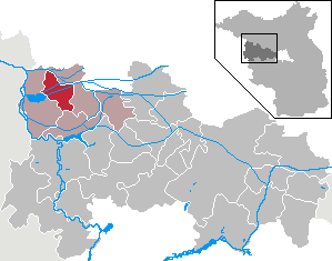
Uckermark is a Kreis (district) in the northeastern part of Brandenburg, Germany. Neighboring districts are Barnim and Oberhavel, the districts Mecklenburgische Seenplatte and Vorpommern-Greifswald in Mecklenburg-Vorpommern, and to the east Poland. It is one of the largest districts of Germany areawise. The district is named after the historical region of Uckermark.

The Black Elster or Schwarze Elster is a 179-kilometre (111 mi) long river in eastern Germany, in the states Saxony, Brandenburg and Saxony-Anhalt, right tributary of the Elbe. Its source is in the Upper Lusatia region, near Elstra.

Lenzen (Elbe) is a small town in the district of Prignitz, in Brandenburg, Germany. The town lies to the north of the Löcknitz River, not far from where the Löcknitz flows into the Elbe. It is part of the Amt Lenzen-Elbtalaue.
Pritzwalk is a town in the district of Prignitz, in Brandenburg, Germany. It is situated 20 km west of Wittstock, and 33 km northeast of Wittenberge. The river Dömnitz flows through Pritzwalk.

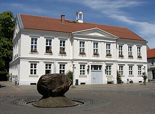
Fürstenberg is a town in the Oberhavel district, Brandenburg, Germany.
Rhinow is a town in the Havelland district (Landkreis), in Brandenburg, Germany. It is situated 16 km north of Rathenow, and 22 km south of Kyritz. Rhinow is the administrative seat (Verwaltungssitz) of the Rhinow district (Amt).

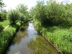
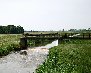
Löcknitz is a river in northern Germany.

The Margraviate of Brandenburg was a major principality of the Holy Roman Empire from 1157 to 1806 that played a pivotal role in the history of Germany and Central Europe.

The Uecker ([]) or Ucker is a river in the northeastern German states of Brandenburg, where it is known as the Ucker, and of Mecklenburg-Vorpommern. Its source lies in the Uckermark district, one kilometer north of Ringenwalde. It flows northward through several lakes. The first one is Großer Krinertsee. The next ones are rather small.

The North German Plain or Northern Lowland is one of the major geographical regions of Germany. It is the German part of the North European Plain. The region is bounded by the coasts of the North Sea and the Baltic Sea to the north, Germany's Central Uplands to the south, by the Netherlands to the west and Poland to the east.

Griebnitzsee is a lake at the south-western outskirts of Berlin, the capital city of Germany. At an elevation of 29.4 m, its surface area is ca. 0.592 km². The lake forms the border between the German states of Berlin and Brandenburg. It is bordered in the north by the Wannsee district of Berlin, and in the south and west by the Babelsberg district of Potsdam in Brandenburg.

Randow is a river in the Uckermark region of Brandenburg and the Vorpommern region of Mecklenburg-Vorpommern, in part constituting these regions' border. An ancient name is Lochnitza, the town of Löcknitz derived its name from it. Since 1700, Randow is exclusively used.
An urstromtal is a type of broad glacial valley, for example, in northern Central Europe, that appeared during the ice ages, or individual glacial periods of an ice age, at the edge of the Scandinavian ice sheet and was formed by meltwaters that flowed more or less parallel to the ice margin. Urstromtäler are an element of the glacial series. The term is German and means "ancient stream valley". Although often translated as "glacial valley", it should not be confused with a valley carved out by a glacier. More accurately some sources call them "meltwater valleys" or "ice-marginal valleys".

The Panke is a small river in Brandenburg and Berlin, a right tributary of the Spree, originating from the Barnim plateau. It has a length of 29 km, of which 20,2 are within the area of Berlin. Consequently, the Panke is the third longest river in the city after the Spree and the Havel. Several areas in Berlin and Brandenburg are named after the Panke, including Pankow and Panketal.

Finow is a river of Brandenburg, Germany. Originally, it flowed into the Oder near Oderberg, but since the creation of the Finow Canal in the 17th century, it flows into this canal near Finowfurt.
The Große Röder is a river of Saxony and Brandenburg, eastern Germany. It is a left tributary of the river Black Elster. It rises near Arnsdorf, about 20 km (12 mi) east of Dresden. It flows in a generally northwestern direction, through the towns Radeberg, Radeburg and Großenhain. It joins the Black Elster in the village Haida, west of Elsterwerda.
Europäische Stammtafeln - German for European Family Trees - is a series of twenty-nine books which contain sets of genealogical tables of the most influential families of Medieval European history. It is a standard reference work for those researching medieval, imperial, royal and noble families of Europe.