Related Research Articles

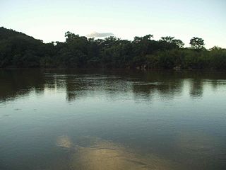
The Tocantins River is a river in Brazil, the central fluvial artery of the country. In the Tupi language, its name means "toucan's beak". It runs from south to north for about 2,450 km. It is not really a branch of the Amazon River, since its waters flow into the Atlantic Ocean alongside those of the Amazon. It flows through four Brazilian states and gives its name to one of Brazil's newest states, formed in 1988 from what was until then the northern portion of Goiás.

Tocantins is one of the 26 states of Brazil. It is the newest state, formed in 1988 and encompassing what had formerly been the northern two-fifths of the state of Goiás. Tocantins covers 277,620.91 square kilometres (107,190.03 sq mi) and had an estimated population of 1,496,880 in 2014. Construction of its capital, Palmas, began in 1989; most of the other cities in the state date to the Portuguese colonial period. With the exception of Araguaína, there are few other cities with a significant population in the state. The government has invested in a new capital, a major hydropower dam, railroads and related infrastructure to develop this primarily agricultural area. The state has 0.75% of the Brazilian population and is responsible for 0.5% of the Brazilian GDP.

The Pará River, also called Parauaú River, Jacaré Grande River, Marajó River Channel, Macacos River Channel, Santa Maria River Channel and Bocas Bay, is a watercourse and immense estuarine complex that functions as a canal between the rivers Amazon, Tocantins, Campina Grande and Marajó Bay, in addition to numerous other smaller rivers. It can also be considered a distributary channel of the Tocantins River.
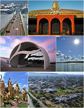
Palmas is the capital and largest city of the state of Tocantins, Brazil. According to IBGE estimates from 2020, the city had 306,296 inhabitants.

Imperatriz is the second most populated city in the northeastern Brazilian state of Maranhão. The city extends along the right bank of the Tocantins River and is crossed by the Belém-Brasília Highway, standing on the border with the state of Tocantins.

The Furnas Dam is a hydroelectric dam in the Minas Gerais state of Brazil. A small settlement was built near the dam with the same name to house the workers during the dam construction. The main purpose of the dam and reservoir are the production of electricity and the regulation of the flow of the Grande River. Near the beginning of 2022, mass amounts of rain caused a large rock to fall and kill 10 people.
The Araguaia National Park is a national park located in Tocantins state in the north of Brazil, between 09º51’—11º11’S and 49º57’—50º27’W. Bananal Island, on which the park is located, is believed to be the largest inland river island in the world.
The Paranã River is located in Goiás and Tocantins states, Brazil. It divides two regions - the Northeast and north-central Goiás. It is formed by tributaries that descend the Serra Geral, the mountains that divide eastern Goiás and Bahia. One of the most important tributaries is the Crixás, which has its source near Formosa. Farther to the north the Paranã becomes the main tributary of the Tocantins River on the right bank. Today it is crossed by a long concrete bridge between the municipalities of Iaciara and Nova Roma. It forms the valley which makes up a vast region called the Vão do Paranã Microregion.

Couto Magalhães is a municipality located in the Brazilian state of Tocantins. Its population was 5,639 (2020) and its area is 1,586 km² (612.4 mi²), a density of 3.07 people/km². It is located 150 m (492.1 ft) above sea level. The demonym is Coutense.
Neoplecostominae is a subfamily of South American catfishes of the family Loricariidae. Species of this subfamily live in high-mountain and swift-flowing river habitats.
The Palma River is a river of Tocantins state in central Brazil.
The Urubu Grande River is a river of Tocantins state in central Brazil.
Figueirópolis is a municipality in the state of Tocantins in the Northern region of Brazil.
Divinópolis do Tocantins is a municipality in the state of Tocantins in the Northern region of Brazil.
Marianópolis do Tocantins is a municipality in the state of Tocantins in the Northern region of Brazil.
Sandolândia is a municipality in the state of Tocantins in the Northern region of Brazil.

Lagoa do Tocantins is a municipality in the state of Tocantins in the Northern region of Brazil.

São Félix do Tocantins is a municipality in the state of Tocantins in the Northern region of Brazil.
Tocantínia is a municipality in the state of Tocantins in the Northern region of Brazil.

The Tocantins basin, or Araguaia-Tocantins basin, is a Brazilian river basin, almost entirely located between the 2ºS and 18ºS parallels and the 46ºW and 56ºW meridians. The main rivers in the basin are Tocantins and Araguaia.
References
Coordinates: 12°25′S49°33′W / 12.417°S 49.550°W