Related Research Articles
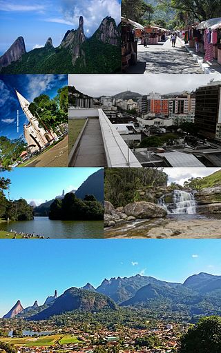
Teresópolis is a Brazilian municipality located in the state of Rio de Janeiro, in a mountainous region known as Região Serrana. The Serra dos Órgãos National Park lies partly within the city limits. The city is known as the home of the Brazil national football team, since it hosts CBF's training ground at Granja Comary.

Iguaçu National Park is a national park in Paraná State, Brazil. It comprises a total area of 185,262.5 hectares and a length of about 420 kilometres (260 mi), 300 kilometres (190 mi) of which are natural borders by bodies of water and the Argentine and Brazilian sides together comprise around 260,000 hectares. Iguaçu National Park was created by federal decree nr. 1035 of January 10, 1939, and became a UNESCO World Heritage Site in 1986. The park is managed by Chico Mendes Institute for Biodiversity Conservation (ICMBio).

The Malheur National Forest is a National Forest in the U.S. state of Oregon. It contains more than 1.4 million acres (5,700 km2) in the Blue Mountains of eastern Oregon. The forest consists of high desert grasslands, sage, juniper, pine, fir, and other tree species. Elevations vary from about 4,000 feet (1,200 m) to the 9,038-foot (2,755 m) peak of Strawberry Mountain. The Strawberry Mountains extend east to west through the center of the forest. U.S. Route 395 runs south to north through the forest, while U.S. Route 26 runs east to west.

Francisco Beltrão, established on December 14, 1952, is a municipality in the state of Paraná in Brazil. In 2010, the population was 80,727, of which 85% lived in the city proper and 15% on the surrounding land. Francisco Beltrão is very close to two other cities, Marmeleiro and Renascença. Its economy is based on agriculture, corn crops, turkey and chicken meat exports, textiles, aluminium pans, mobile industries, public services and small commerce.

Cobija is a city in Bolivia, capital of the department of Pando, is located about 600 km (373 mi.) north of La Paz in the Amazon Basin on the border with Brazil. Cobija lies on the banks of the Rio Acre across from the Brazilian city of Brasiléia. Cobija lies at an elevation of ca. 280 m (920 ft.) above sea level and has a tropical and rainy climate.
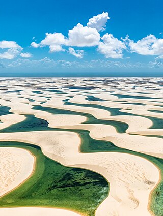
Lençóis Maranhenses National Park is a national park in Maranhão state in northeastern Brazil, just east of the Baía de São José. Protected on June 2, 1981, the 155,000 ha (380,000-acre) park includes 70 km (43 mi) of coastline, and an interior composed of rolling sand dunes. During the rainy season, the valleys among the dunes fill with freshwater lagoons, prevented from draining due to the impermeable rock beneath. The park is home to a range of species, including four listed as endangered, and has become a popular destination for ecotourists.

Brasiléia is a Brazilian municipality located in the northern state of Acre. Its population in 2020 was estimated at 26,702 inhabitants. Its area is 336,189 km2. Located 237 km south of Rio Branco on the border with Bolivia, has its limits with the municipalities Epitaciolândia, Assis Brasil, Sena Madureira and Xapuri.

Porto Acre is a municipality located in the northeast of the Brazilian state of Acre. The economy is mainly based on agriculture. As of 2020 the municipality had an estimated population of 18,824.
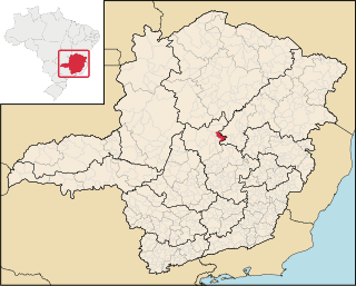
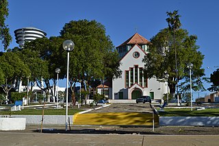
Monjolos is a Brazilian municipality located in the northeast of the state of Minas Gerais. Its population in 2020 was 2,202, with a total area of 652 square kilometres (252 sq mi). The city belongs to the statistical mesoregion of Central Mineira and to the statistical microregion of Curvelo. It became a municipality in 1962.
Jequitinhonha is a Brazilian municipality located in the northeast of the state of Minas Gerais.

Nova Porteirinha is a municipality in the north of the state of Minas Gerais in Brazil. The population in 2020 was 7,497 in an area of 121 km2 (47 sq mi). The elevation is 533 meters (1,749 ft). It became a municipality in 1997. The postal code (CEP) is 39525-000.

Delta is a Brazilian municipality located in the west of the state of Minas Gerais. Its population as of 2020 was estimated to be 10,768 people living in a total area of 104 square kilometres (40 sq mi). The city belongs to the mesoregion of Triângulo Mineiro and Alto Paranaíba and to the micro-region of Uberaba. It became a municipality in 1997.
Iaco River is a river of Acre and Amazonas states in western Brazil.

The Big Muddy National Fish and Wildlife Refuge was established in 1994, and has grown to over 16,700 acres (68 km2). Like pearls on a string, these acres are spread out as individual units along the Missouri River between Kansas City and St. Louis. These pearls of habitat benefit floodplain-dependent fish and wildlife species. The Big Muddy Refuge is planning to grow to 60,000 acres (240 km2) by buying land from willing sellers who want to see their properties set aside for the benefit of wildlife and the enjoyment of all.

Piracuruca is a municipality in the state of Piauí in the Northeast region of Brazil.

Alcobaça is a municipality of Bahia, Brazil.
The Salto Osório Hydroelectric Power Plant is a dam and hydroelectric power plant on the Iguazu River near Osório in Paraná, Brazil. It is the second dam upstream of the Iguazu Falls and was completed in 1979. The power station has a 1,078 MW capacity and is supplied with water by a rock-fill embankment dam.
The Três Marias Dam, also known as Bernardo Mascarenhas, is an embankment dam on the São Francisco River near Três Marias in Minas Gerais, Brazil. It was constructed for hydroelectric power production and flood control. The dam was completed in 1961 and its first generator was operational in 1962. The dam's power plant is named after Bernard Mascarenhas who in 1889, built South America's first major hydroelectric power plant in Brazil, the Marmelos Zero Power Plant.

Brasileira is a municipality in the state of Piauí in the Northeast region of Brazil.
References
Coordinates: 10°00′S68°42′W / 10.000°S 68.700°W