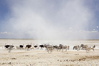
Etosha National Park is a national park in northwestern Namibia and one of the largest national parks in Africa. It was proclaimed a game reserve in March 1907 in Ordinance 88 by the Governor of German South West Africa, Friedrich von Lindequist. It was designated as Wildschutzgebiet in 1958, and was awarded the status of national park in 1967, an act of parliament of the Republic of South Africa. It spans an area of 22,270 km2 (8,600 sq mi) and was named after the large Etosha pan which is almost entirely within the park. With an area of 4,760 km2 (1,840 sq mi), the Etosha pan covers 23% of the total area of the national park. The area is home to hundreds of species of mammals, birds and reptiles, including several threatened and endangered species such as the black rhinoceros. Sixty-one black rhinoceros were killed during poaching in Namibia during 2022, 46 of which were killed in Etosha.

The Namib-Naukluft Park is a national park in western Namibia, situated between the coast of the Atlantic Ocean and the edge of the Great Escarpment. It encompasses part of the Namib Desert, the Naukluft mountain range, and the lagoon at Sandwich Harbour. The best-known area of the park and one of the main visitor attractions in Namibia is Sossusvlei, a clay pan surrounded by dunes, and Sesriem, a small canyon of the Tsauchab. The desert research station of Gobabeb is situated within the park.

The Etosha Pan is a large endorheic salt pan, forming part of the Cuvelai-Etosha Basin in the north of Namibia. It is a vast hollow in the ground in which water may collect or in which a deposit of salt remains after water has evaporated. The 120-kilometre-long (75-mile-long) dry lakebed and its surroundings are protected as Etosha National Park, Namibia's second-largest wildlife park, covering 22,270 square kilometres (8,600 sq mi). The pan is mostly dry but after heavy rains it is flooded with a thin layer of water, which is heavily salted by the mineral deposits on the surface.

Okaukuejo is the administrative center for the Etosha National Park in Namibia. It is located approximately 650 km from the capital Windhoek. An average annual rainfall of around 350 millimetres (14 in) is received, although in the 2010/2011 rainy season 676 millimetres (26.6 in) were measured.

Burchell's zebra is a southern subspecies of the plains zebra. It is named after the British explorer and naturalist William John Burchell. Common names include bontequagga, Damaraland zebra, and Zululand zebra. Burchell's zebra is the only subspecies of zebra which may be legally farmed for human consumption.
Namutoni is a restcamp on the edge of the Etosha pan in the Oshikoto Region in northern Namibia. It is one of the entrance gates to Etosha National Park.
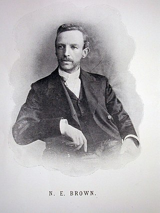
Nicholas Edward Brown was an English plant taxonomist and authority on succulents. He was also an authority on several families of plants, including Asclepiadaceae, Aizoaceae, Labiatae and Cape plants.

The wildlife of Namibia is composed of its flora and fauna. Namibia's endangered species include the wild dog, black rhino, oribi and puku.

The sabota lark is a species of lark in the family Alaudidae. It is found in southern Africa in its natural habitats of dry savannah, moist savannah, and subtropical or tropical dry shrubland. It is generally sedentary but local movements occur in drier regions. The species name is derived from sebotha or sebothé, the Tswana generic name for a lark.
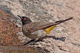
The African red-eyed bulbul or black-fronted bulbul is a species of songbird in the family Pycnonotidae. It is found in south-western Africa. Its natural habitats are dry savanna, subtropical or tropical dry shrubland, and riverine scrub. It feeds on fruit, flowers, nectar, and insects.
Tsumeb railway station is a station located in the mining town of Tsumeb in northeastern Namibia.

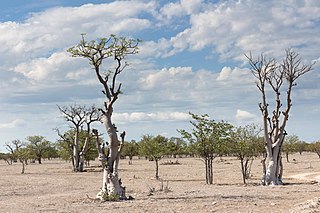
Angolan mopane woodlands are situated in southwestern Angola, extending into northern Namibia. This ecosystem surrounds Etosha Pan, which is considered a separate ecoregion. The mopane trees are the main type of vegetation.

The Ekuma River is one of three rivers that supply most of water to the pan in the Etosha National Park in Namibia, the other two being the Oshigambo River and the Omurambo Ovambo River. The Ekumo is an ephemeral river that occasionally flows, or forms pools, during the rainy season. It originates from the southern shores of Lake Oponono and is 250 kilometres (160 mi) long.
Halali Airport is an airport serving the resort of Halali, in the Oshikoto Region of Namibia. The resort is near some of the waterholes of the Etosha National Park, and has elevated viewing platforms for observing native wildlife like elephants, rhinoceros, and leopards.
Namutoni Airport is an airport serving Namutoni and the Etosha National Park in Namibia. Namutoni is an entrance gate to the park.
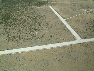
Okaukuejo Airport is an airport in the Oshana Region of Namibia, serving the Etosha National Park and its administrative center, Okaukuejo. The runways are 3 kilometres (1.9 mi) north of the village.
Moringa ovalifolia is a succulent flowering tree of the family Moringaceae native to Namibia and southwestern Angola.
Etosha Commando was a light infantry regiment of the South West Africa Territorial Force. It formed part of the Area Force Units as well as the Territorial Reserve.

The Angolan giraffe, also known as the Namibian giraffe or smokey giraffe, is a species or subspecies of giraffe that is found in northern Namibia, south-western Zambia, Botswana, western Zimbabwe and since mid-2023 again in Angola.
