Related Research Articles

Albury is a major regional city in New South Wales, Australia. It is located on the Hume Highway and the northern side of the Murray River. Albury is the seat of local government for the council area which also bears the city's name – the City of Albury. It is on the Victoria–New South Wales border.

The Bluebell Railway is an 11 mi (17.7 km) heritage line almost entirely in West Sussex in England, except for Sheffield Park which is in East Sussex. It is managed by the Bluebell Railway Preservation Society. It uses steam trains which operate between Sheffield Park and East Grinstead, with intermediate stations at Horsted Keynes and Kingscote.

New Cross Gate is a railway station in New Cross, London, on the Brighton Main Line and the London Overground. It is 2 miles 70 chains down the line from London Bridge and is about 600 m (660 yd) west of New Cross station. It is in Travelcard Zone 2, and is operated by London Overground.

Olympic Highway is a 317-kilometre (197 mi) rural road in the central western and south-eastern Riverina regions of New South Wales, Australia. It services rural communities, links Hume Highway with Mid-Western Highway, and provides part of an alternate road link between Sydney and Albury via Bathurst and Cowra as well as servicing Wagga Wagga, linking with Sturt Highway.

The Hallam Line is a railway connecting Leeds and Sheffield via Castleford in the West Yorkshire Metro area of northern England. It is a slower route from Leeds to Sheffield than the Wakefield line. Services on this line are operated by Northern Trains. Services from Leeds to Nottingham also use the line.
The Wakefield line is a railway line and service in the West Yorkshire Metro and South Yorkshire Passenger Transport Executive areas of northern England. The Wakefield line is coloured yellow on maps and publications by West Yorkshire Metro. The line was electrified in 1989, between Leeds & Wakefield Westgate, as part of the programme to electrify the East Coast Main Line.

Kellyville Ridge is a suburb of Sydney, in the state of New South Wales, Australia. Kellyville Ridge is located 41 kilometres north-west of the Sydney central business district in the local government area of City of Blacktown. It is part of Greater Western Sydney.
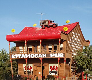
The Ettamogah Pub is a cartoon pub that was featured in the now defunct Australasian Post magazine. The cartoonist Ken Maynard, loving empty spaces and having nothing around him, enjoyed an area just outside Albury at Table Top, New South Wales, named Ettamogah, thus christening the eponymous name of his now famous pub the "Ettamogah Pub". The "Ettamogah Pub" chain of such pubs now exist in various parts of Australia including Sydney in New South Wales, and Cunderdin in Western Australia.

A dry port is an inland intermodal terminal directly connected by road or rail to a seaport, operating as a centre for the transshipment of sea cargo to inland destinations.

Girvan railway station is a railway station serving the town of Girvan, South Ayrshire, Scotland. The station is managed by ScotRail, who operate all passenger services from there. It is on the Ayr to Stranraer section of the Glasgow South Western Line and is situated 62 miles south of Glasgow Central. It has two platforms and is the location of one of the five passing loops on the single track line between Dalrymple Junction and Stranraer. Immediately south of the station, the line climbs steeply towards Pinmore tunnel – the climb is known as the Glendoune Bank and has a ruling gradient of 1 in 54.
The Glasgow, Barrhead and Kilmarnock Joint Railway was a railway jointly owned by the Caledonian Railway and the Glasgow and South Western Railway, completed in 1873, and giving the latter a shorter access to its Carlisle main line. A branch to Beith was also built.

Pelsall railway station is a disused railway station that served the villages of Pelsall and Shelfield in the Metropolitan Borough of Walsall, West Midlands, England. It was on the South Staffordshire Line between Walsall and Lichfield.

Table Top is an outer suburb of the city of Albury, New South Wales, located 16 kilometres (10 mi) north of Albury and 19 kilometres (12 mi) west of Bowna. At the 2021 census, Table Top had a population of 1,516. The area used to be part of the Greater Hume Shire but was recently integrated into the City of Albury.
Springdale Heights is a suburb of the city of Albury, New South Wales, located north of the Albury Central Business District and north of Lavington At the 2006 census, Springdale Heights had a population of 1761, although the area covered in the Census includes parts of Table Top.

The Bristol and South Wales Union Railway was built to connect Bristol, England, with south Wales. The route involved a ferry crossing of the River Severn but was considerably shorter than the alternative route through Gloucester. The ferry was replaced by the Severn Tunnel in 1886 but part of the route continues to be used, forming parts of the Cross-Country Route and the South Wales Main Line.
References
- ↑ Ettamogah station. NSWrail.net. Accessed 8 August 2009.
| Preceding station | Former Services | Following station | ||
|---|---|---|---|---|
| Albury Racecourse towards Albury | Main Southern Line | Table Top towards Sydney | ||
| | This article about a railway station in New South Wales is a stub. You can help Wikipedia by expanding it. |