
Geodesy, is the Earth science of accurately measuring and understanding Earth's geometric shape, orientation in space, and gravitational field. The field also incorporates studies of how these properties change over time and equivalent measurements for other planets. Geodynamical phenomena include crustal motion, tides, and polar motion, which can be studied by designing global and national control networks, applying space and terrestrial techniques, and relying on datums and coordinate systems.

Physical geodesy is the study of the physical properties of the gravity field of the Earth, the geopotential, with a view to their application in geodesy.

The World Geodetic System (WGS) is a standard for use in cartography, geodesy, and satellite navigation including GPS. This standard includes the definition of the coordinate systems fundamental and derived constants, the ellipsoidal (normal) Earth Gravitational Model (EGM), a description of the associated World Magnetic Model (WMM), and a current list of local datum transformations.
The figure of the Earth is the size and shape of the Earth in geodesy. Its specific meaning depends on the way it is used and the precision with which the Earth's size and shape is to be defined. While the sphere is a close approximation of the true figure of the Earth and satisfactory for many purposes, geodesists have developed several models that more closely approximate the shape of the Earth so that coordinate systems can serve the precise needs of navigation, surveying, cadastre, land use, and various other concerns.
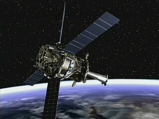
Gravity Probe B (GP-B) was a satellite-based mission to test two unverified predictions of general relativity: the geodetic effect and frame-dragging. This was to be accomplished by measuring, very precisely, tiny changes in the direction of spin of four gyroscopes contained in an Earth satellite orbiting at 650 km (400 mi) altitude, crossing directly over the poles.

In satellite laser ranging (SLR) a global network of observation stations measures the round trip time of flight of ultrashort pulses of light to satellites equipped with retroreflectors. This provides instantaneous range measurements of millimeter level precision which can be accumulated to provide accurate measurement of orbits and a host of important scientific data.
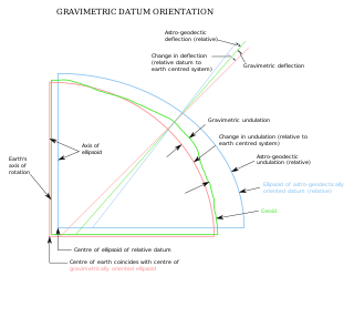
The vertical deflection at a point on the Earth is a measure of how far the gravity direction has been shifted by local anomalies such as nearby mountains. They are widely used in geodesy, for surveying networks and for geophysical purposes.
A geodetic datum or geodetic system is a coordinate system, and a set of reference points, used to locate places on the Earth. An approximate definition of sea level is the datum WGS 84, an ellipsoid, whereas a more accurate definition is Earth Gravitational Model 2008 (EGM2008), using at least 2,159 spherical harmonics. Other datums are defined for other areas or at other times; ED50 was defined in 1950 over Europe and differs from WGS 84 by a few hundred meters depending on where in Europe you look. Mars has no oceans and so no sea level, but at least two martian datums have been used to locate places there.
Satellite geodesy is geodesy by means of artificial satellites — the measurement of the form and dimensions of Earth, the location of objects on its surface and the figure of the Earth's gravity field by means of artificial satellite techniques. It belongs to the broader field of space geodesy. Traditional astronomical geodesy is not commonly considered a part of satellite geodesy, although there is considerable overlap between the techniques.
Geodetic astronomy or astro-geodesy is the application of astronomical methods into networks and technical projects of geodesy.
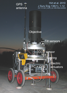
A zenith camera is an astrogeodetic telescope used today primarily for the local surveys of Earth's gravity field. Zenith cameras are designed as transportable field instruments for the direct observation of the plumb line and vertical deflections.
Stellar triangulation is a method of geodesy which uses cosmic instead of terrestrial targets. It was first done by the Finnish geodesist Väisälä in 1959, who made astrometric photographs of the sky at two stations together with a balloon probe between them.
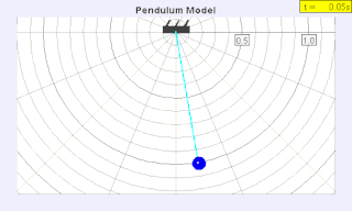
A seconds pendulum is a pendulum whose period is precisely two seconds; one second for a swing in one direction and one second for the return swing, a frequency of 1/2 Hz. A pendulum is a weight suspended from a pivot so that it can swing freely. When a pendulum is displaced sideways from its resting equilibrium position, it is subject to a restoring force due to gravity that will accelerate it back toward the equilibrium position. When released, the restoring force combined with the pendulum's mass causes it to oscillate about the equilibrium position, swinging back and forth. The time for one complete cycle, a left swing and a right swing, is called the period. The period depends on the length of the pendulum, and also to a slight degree on its weight distribution and the amplitude (width) of the pendulum's swing.
Arne Bjerhammar was a Swedish geodesist. He was professor at Royal Institute of Technology (KTH) in Stockholm. He was born in Båstad, Scania in the south of Sweden.
An Earth ellipsoid is a mathematical figure approximating the Earth's form, used as a reference frame for computations in geodesy, astronomy, and the geosciences. Various different ellipsoids have been used as approximations.
The term fundamental station is used for special observatories which combine several space positioning techniques like VLBI, satellite laser ranging, GPS, Glonass, etc. They are the basis of plate tectonic analysis, allowing the monitoring of continental drift rates with milimetre accuracies. A fundamental point is the geometric origin of a geodetic network and defines the geodetic datum of a national survey.
Regional Reference Frame Sub-Commission for Europe (EUREF) is the sub-commission of the International Association of Geodesy (IAG), part of the Sub-Commission 1.3, under IAG Commission 1 . EUREF deals with the definition, realization and maintenance of the European Geodetic Reference Frame. The goal of EUREF is to establish a unified geodetic datum (ETRS89) and a consistent network of reference stations (EPN) throughout Europe. EUREF was founded in 1987 at the IUGG General Assembly held in Vancouver.
The International Association of Geodesy is a constituent Association of the International Union of Geodesy and Geophysics. It was founded in 1862 as the Mitteleuropäische Gradmessung became the Europäische Gradmessung in 1867, the Internationale Erdmessung in 1886 and took its present name in 1946. At present there are 4 commissions and one inter-commission committee:

Explorer 29 was an American satellite launched as part of the Explorers program, being the first of the two satellites GEOS. Explorer 29 was launched on 6 November 1965 from Cape Canaveral, Florida, United States, with Delta rocket.

