
The Ahaura River is in the South Island of New Zealand. This river drains the western flanks of the Southern Alps and flows into the Grey River.

The Waimakariri River is one of the largest rivers in Canterbury, on the eastern coast of New Zealand's South Island. It flows for 151 kilometres (94 mi) in a generally southeastward direction from the Southern Alps across the Canterbury Plains to the Pacific Ocean.

Crooked River is a river that flows from headwaters in the Southern Alps to Lake Brunner in the West Coast region of New Zealand's South Island. It is named for the erratic path it takes. Near Lake Brunner, it passes through reasonably flat farmland, but closer to its source, it rushes through gorges and rapids. One tributary is the Poerua River from Lake Poerua.
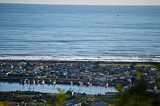
Blaketown is a suburb to the west of Greymouth on the West Coast of New Zealand. The Grey River separates Blaketown from Cobden, and the Blaketown Lagoon separates it from the centre of Greymouth.

The Doubtful River is a river in the Canterbury region of New Zealand. It rises near Mount Barron and flows south then south-east through Lake Sumner Forest Park, reaching the Boyle River 40 kilometres (25 mi) west of Hanmer Springs. The Doubtful Range lies to the south. The Doubtless River and Devilskin Stream are tributaries entering from the north.

The Hanmer River is a river in the Hurunui District of New Zealand. It originates in the Hossack Saddle between the Hanmer Range and the Amuri Range, and flows south-west into the Waiau Uwha River about 8 kilometres (5.0 mi) south-west of Hanmer Springs.

The Harman River is a river of New Zealand. It starts in the Browning Range of the Southern Alps and becomes the Arahura River, which flows into the Tasman Sea north of Hokitika.

The Haupiri River is a river of New Zealand. It starts near Mount Dixon in the Kaimata Range of the Southern Alps and flows north-west near to Lake Haupiri, then north-east to join the Ahaura River. The Ahaura joins the Grey River which flows into the Tasman Sea at Greymouth.
The Kaniere River is a river of New Zealand. It is located in the West Coast Region of the South Island. The river is the outflow of Lake Kaniere, and flows west to reach the Hokitika River five kilometres from the coast of the Tasman Sea.

The Kokatahi River is a river of the West Coast Region of New Zealand's South Island. A major tributary of the Hokitika River, it flows northwest from its origins on the northern slopes of Mount Ambrose, reaching the Hokitika River 12 kilometres from the latter's mouth at Hokitika. The two rivers between them share one of the West Coast's larger floodplains.

The Mathias River is a river of the Canterbury region of New Zealand's South Island. It flows from its origins in three rivers in the Southern Alps. Of these, the North Mathias River is the longest, flowing predominantly southwards from its source northeast of Mount Williams. After 18 kilometres (11 mi) its waters combine with those of the West Mathias River, which flows predominantly southwest for 13 kilometres (8 mi) from its sources 10 kilometres (6 mi) west of Mount Williams. The South Mathias River, a tributary of the West Mathias River, is a 6-kilometre (4 mi) long easterly-flowing river which meets the West Mathias 5 kilometres (3 mi) from its confluence with the North Mathias.
The Morgan River is a river of the West Coast Region of New Zealand's South Island. It flows generally west from the small Lake Morgan, high in the Kaimata Range of the Southern Alps, reaching the Crooked River 18 kilometres (11 mi) from the latter's outflow into Lake Brunner.
The Ōrangipuku River is a river of the West Coast Region of New Zealand's South Island. It flows north into the southern end of Lake Brunner.
The Rough River, alternatively known as the Otututu River is a river of the West Coast Region of New Zealand's South Island. A major tributary of the Grey River, it flows south from its sources near Mount Uriah in the Paparoa Range 20 kilometres southeast of Charleston, to reach the Grey River to the southwest of the settlement of Ikamatua. The river is currently shown on maps as Otututu (Rough) River, although this orthography is no longer common for New Zealand Rivers.

The Toaroha River is a river of the West Coast Region of New Zealand's South Island. It flows generally north through a valley between the Toaroha and Diedrichs Ranges to reach the Kokatahi River 25 kilometres southeast of Hokitika.
The Upper Grey River is a river of the West Coast Region of New Zealand's South Island. As the name suggests, it is a stretch of the Grey River, and the name is used for the section between the confluence of the Blue Grey River, Brown Grey River, and Crooked Mary Creek in the Southern Alps and the Upper Grey's confluence with the Little Grey River 25 kilometres southwest of Reefton.
The Waikiti River is a river of the West Coast Region of New Zealand's South Island. It flows generally north from it sources in the eastern Kaimata Range, roughly paralleling the course of its larger eastern neighbour, the Trent River. It reaches the Ahaura River 20 kilometres southeast of Lake Hochstetter.
The Big River is a river in the Grey District, in the West Coast region of New Zealand's South Island. It is a tributary of the Grey River.
The Taipo River is a river of the central West Coast Region of New Zealand's South Island. It flows north from its sources west of Mount Rolleston, fed by the waters of several mountain streams. After some 15 kilometres it turns northeast to flow past the Bald Range before reaching the valley of the Taramakau River into which it flows 35 kilometres east of Hokitika.
The Tūtaekurī River starts near the Hope Pass, in the Southern Alps and flows north-west to join the Ahaura River. The Ahaura joins the Grey River which flows to the Tasman Sea at Greymouth. Tūtaekurī River has been its official name since 21 June 2019. Tūtae kurī is a grass with the latin name agropyron multiflorum.
