Leskov Island is a small uninhabited island in the Traversay Islands group of the South Sandwich Islands. It is less than 1 nautical mile (2 km) long, and lies 30 nautical miles (56 km) west of Visokoi Island. It was discovered in 1819 by a Russian expedition under Fabian Gottlieb von Bellingshausen, who named it for the third lieutenant on the expedition ship Vostok.
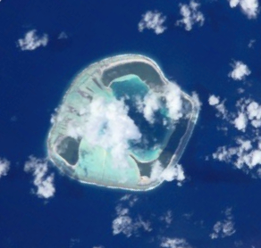
Motu One, also known as Bellinghausen, is an atoll in the Leeward group of the Society Islands. Motu One is located 550 km northwest from Tahiti and 72 km northeast of Manuae, its closest neighbor.
Bellingshausen may refer to:
Wilson Harbour is a bay 1.5 miles wide and 3 miles long, between Kade Point and Cape Demidov along the south coast of South Georgia. This coast was roughly charted by a Russian expedition under Fabian Gottlieb von Bellingshausen in 1819. Wilson Harbour was named about 1912, probably for J. Innes Wilson, who sketched some of the inland portions of the island at about that time.

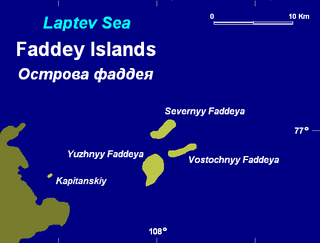
Kolchak Island or Kolchaka Island, is an island in the Kara Sea located in a coastal area of skerries NE of the Shturmanov Peninsula. It is near the southern end of the Nordenskiöld Archipelago, but not geographically part of it.

The Taymyr Gulf is a gulf in the Kara Sea that includes the estuary of the Lower Taymyr River.
Lazarev Bay is a rectangular bay, 15 nautical miles (28 km) long and 13 nautical miles (24 km) wide, which separates Alexander Island from Rothschild Island and is bounded on the south side by the Wilkins Ice Shelf, which joins the east portion of Rothschild Island and the west portion of Alexander Island. Two minor islands, Dint Island and Umber Island, lie merged within the ice of the Wilkins Ice Shelf within Lazarev Bay.
The Simsa Bay or Bay of Sims is a gulf in the Laptev Sea on the coast of the Taymyr Peninsula.

The Yana Bay is the most important gulf of the Laptev Sea. It is located between Cape Buor-Khaya on its western side and the Ebelyakh Bay at its eastern end.

Lahetaguse is a village in Saaremaa Parish, Saare County, Estonia, on the island of Saaremaa. It's located on the northern coast of Kaugatoma Bay. As of 2011 Census, the settlement's population was 21.

The first Russian circumnavigation of the Earth took place from August 1803 to August 1806. It was sponsored by Count Nikolay Rumyantsev, funded by the Russian-American Company, and was headed by Adam Johann von Krusenstern. In addition to its exploratory goals, the expedition was also meant to help establish diplomatic and economic relations between Russia and Japan, for which the party included a large diplomatic delegation headed by Court Chamberlain and Ambassador Nikolai Rezanov.

Demidov Island is a small island 9.3 kilometres (5 nmi) north of the mouth of Rayner Glacier and 17 kilometres (9 nmi) southwest of the Hydrographer Islands along the coast of Enderby Land. It appears that the island was mapped by both the Australian National Antarctic Research Expeditions and the Soviet expedition in 1957. It was named by the Soviet expedition for Lieutenant Dimitri Demidov of the Russian expedition of 1819–21 under Fabian Gottlieb von Bellingshausen.
Forsters Passage is a body of water between Bristol Island and Southern Thule in the South Sandwich Islands. In 1775, a British expedition under James Cook gave the name "Forster's Bay", after John R. Forster, a naturalist with the expedition, to what appeared to be a bay in essentially this position. The "bay" was determined to be a strait by a Russian expedition under Fabian Gottlieb von Bellingshausen in 1820.

The Lazarev Sea is a proposed name for a marginal sea of the Southern Ocean. It would be bordered by two proposals from a 2002 International Hydrographic Organization (IHO) draft, a King Haakon VII Sea to the west and a Riiser-Larsen Sea to the east, or between the Prime Meridian of 0° and 14°E. It would stretch over an area of 929,000 km2 (359,000 sq mi).

Vostok was a 28-gun sloop-of-war of the Imperial Russian Navy, the lead ship of the First Russian Antarctic Expedition in 1819—1821, during which Fabian Gottlieb von Bellingshausen and Mikhail Lazarev circumnavigated the globe, discovered the continent of Antarctica and twice circumnavigated it, and discovered a number of islands and archipelagos in the Southern Ocean and the Pacific.

Mirny was a 20-gun sloop-of-war of the Imperial Russian Navy, the second ship of the First Russian Antarctic Expedition in 1819—1821, during which Fabian Gottlieb von Bellingshausen and Mikhail Lazarev circumnavigated the globe, discovered the continent of Antarctica and twice circumnavigated it, and discovered a number of islands and archipelagos in the Southern Ocean and the Pacific.
William (Bill) Barr is a Scottish historian now resident of Calgary, Canada, with a specific interest in the history of exploration of the Arctic, and to a lesser degree, the Antarctic. He holds degrees in Geography from the University of Aberdeen, Scotland and McGill University, Québec, Canada. From 1968 until 1999 he was a member of the faculty of the Department of Geography, University of Saskatchewan, Saskatoon, Canada and is now a professor emeritus there.