Related Research Articles

Niterói is a municipality of the state of Rio de Janeiro in the southeast region of Brazil. It lies across Guanabara Bay facing the city of Rio de Janeiro and forms part of the Rio de Janeiro Metropolitan Area. It was the state capital, as marked by its golden mural crown, from 1834 to 1894 and again from 1903 to 1975. It has an estimated population of 515,317 inhabitants (2020) and an area of 129.375 km2 (49.952 sq mi), making it the fifth most populous city in the state. It has the highest Human Development Index of the state and the seventh highest among Brazil's municipalities in 2010. Individually, it is the second municipality with the highest average monthly household income per capita in Brazil and appears in 13th place among the municipalities of the country according to social indicators related to education. The city has the nicknames of Nikiti, Nicki City and the Smile City (Cidade Sorriso).
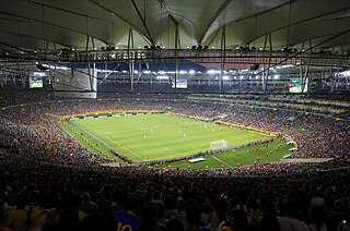
Maracanã Stadium, officially named Estádio Jornalista Mário Filho, is an association football stadium in Rio de Janeiro, Brazil. The stadium is part of a complex that includes an arena known by the name of Maracanãzinho, which means "The Little Maracanã" in Portuguese. Owned by the Rio de Janeiro state government, the stadium is now managed by the clubs Flamengo and Fluminense. It is located at the Maracanã neighborhood, named after the Rio Maracanã, a now canalized river in Rio de Janeiro.

Nova Iguaçu is a municipality in Rio de Janeiro state in Brazil.

Rodrigo de Freitas Lagoon is a lagoon in the district of Lagoa in the Zona Sul area of Rio de Janeiro. The lagoon is connected to the Atlantic Ocean, allowing sea water to enter by a canal along the edge of a park locally known as Jardim de Alah.

The Federal Center for Technological Education "Celso Suckow da Fonseca", also known as Federal Center for Technological Education of Rio de Janeiro, is one of the most traditional Brazilian federal educational institution subordinated to the Brazilian Ministry of Education. It offers undergraduate and post-graduate level courses in addition to its sought-after technical high school courses.

The Baixada Fluminense is a region in the state of Rio de Janeiro, in southeastern Brazil. It is located on Guanabara Bay, between Rio de Janeiro to the south and the Serra dos Órgãos range of hills to the north.

Nilópolis is a municipality in Brazil, located in the Rio de Janeiro state's southwestern region, bordering São João de Meriti, Mesquita and Rio de Janeiro. It is the smallest municipality in Rio de Janeiro state, with a total area of 19.39 km2. The population of 162,693 inhabitants living in an area of 9 km2 and the remaining area corresponds to the Gericinó's Natural Park. Officially, the population density exceeds 8,120 inhabitants/km2, but if calculated just 9 km2 occupied, it becomes the most densely populated city in Brazil with more than 17.400 inhabitants/km2. Currently, São João de Meriti has the highest population density, with 12,897 inhabitants/km2.

Greater Rio de Janeiro, officially the Rio de Janeiro Metropolitan Region is a large metropolitan area located in Rio de Janeiro state in Brazil, the second largest in Brazil and third largest in South America. It consists of 22 municipalities, including the state capital, Rio de Janeiro.
The Federal Rural University of Rio de Janeiro is a public university located in Seropédica in the State of Rio de Janeiro, Brazil. It possesses the largest campus among Latin American universities and is known for being the first university to offer agriculture related courses in Brazil.
The Guandu-Mirim River is in the state of Rio de Janeiro in southeastern Brazil.
The Mazomba River is a river of Rio de Janeiro state in southeastern Brazil.
The Pavuna River is a river of Rio de Janeiro state in southeastern Brazil.
The Piranema River is a river of Rio de Janeiro state in southeastern Brazil.
The Queimados River is a river of Rio de Janeiro state in southeastern Brazil.
The São João de Meriti River is a river of Rio de Janeiro state in southeastern Brazil.

The Trapicheiros River is a river of Rio de Janeiro state in southeastern Brazil.

The April 2010 Rio de Janeiro floods and mudslides was an extreme weather event that affected the State of Rio de Janeiro in Brazil in the first days of April 2010. At least 212 people died, 161 people have been injured, while at least 15,000 people have been made homeless. A further 10,000 homes are thought to be at risk from mudslides, most of them in the favelas, the shanty towns built on the hillsides above downtowns. Damage from the flooding has been estimated at $23.76 billion reais, about 8% of the gross domestic product (GDP) of Rio de Janeiro State.

Fort Copacabana is a military base at the south end of the beach that defines the district of Copacabana, Rio de Janeiro. The base is open to the public and contains the Museu Histórico do Exército and a coastal defense fort that is the actual Fort Copacabana.
Bancários is a neighborhood located at Ilha do Governador in the North Zone of Rio de Janeiro, Brazil. As of 2010 it has a population of 12,512.

The Legislative Assembly of Rio de Janeiro is the unicameral legislature of Rio de Janeiro, a state in Brazil. It has 70 state deputies elected by proportional representation.
References
Coordinates: 22°12′S43°11′W / 22.200°S 43.183°W