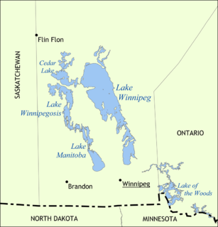
Lake Manitoba is Canada's thirteenth largest lake (4,624 km2) and the world's 33rd largest freshwater lake. It is in central North America, in the Canadian province of Manitoba, which is named after the lake. It is located about 75 km northwest of the province's capital, Winnipeg, at 51°0′N 98°45′W.

Lechlade, or Lechlade-on-Thames, is a town at the southern edge of the Cotswolds in Gloucestershire, England, 55 miles (89 km) south of Birmingham and 68 miles (109 km) west of London. It is the highest point at which the River Thames is navigable, although there is a right of navigation that continues south-west into Cricklade, situated in the neighbouring county of Wiltshire. The town is named after the River Leach that joins the Thames near The Trout Inn and St. John's Bridge.

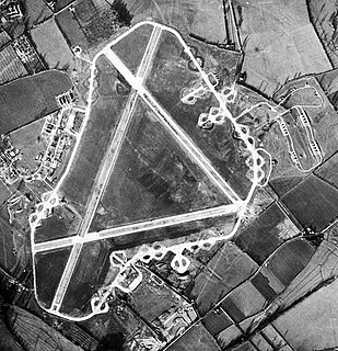
The Royal International Air Tattoo (RIAT) is the world's largest military air show, held annually over the third weekend in July, usually at RAF Fairford in Gloucestershire, England in support of The Royal Air Force Charitable Trust. The show typically attracts a total of 150,000 to 160,000 spectators over the weekend.
Philip Castle, is a British airbrush artist.

Kempsford is a village and civil parish in Gloucestershire, England, about 2.5 miles (4 km) south of Fairford. RAF Fairford is located near the village. The population was around 1,120 at the 2011 census.

Fairford Town Football Club is a football club based in Fairford, Gloucestershire, England. Affiliated to the Gloucestershire County Football Association, they are currently members of the Hellenic League Premier Division and play at Cinder Lane.

The Silver Swallows was the name of Irish Air Corps Aerobatic Team. Active from 1986 to 1998. The team was equipped with four Fouga CM170 Magister jet trainers, and was drawn from the Light Strike Squadron of the Irish Air Corps based at Casement Aerodrome, Baldonnel near Dublin. The name Silver Swallows was derived from the colour of the aircraft, and the 'V'-shaped tail of the Magister aircraft the team flew. Throughout its history the team was operated on a part-time basis, with the display duties of the team being secondary to the primary roles of the Light Strike Squadron.

No 620 Squadron was a squadron of the Royal Air Force during World War II. During its existence it served as a bomber squadron, airborne forces and a transport squadron.
The Oxford, Witney and Fairford Railway was a single track railway branch line, 22 miles (35 km) long, in Oxfordshire and Gloucestershire. It was opened in succession by two companies, the first in 1861 to connect the important woollen town of Witney to the main line network, and the second in 1873 as the rump of an ambitious scheme to connect to Cheltenham, but which ran only between Witney and Fairford. The junction with the main line was at Yarnton, north of Oxford.
RAF Down Ampney was a Royal Air Force station located 1.8 miles (2.9 km) north east of Cricklade, Wiltshire and 3 miles (4.8 km) south west of RAF Fairford, Gloucestershire. The airfield operated during World War II from February 1944 until February 1947.
Brize Norton and Bampton railway station was a railway station 1 mile (1.6 km) south of the village of Brize Norton on the Oxford, Witney and Fairford Railway between Oxford and Fairford. The station had two stone-built platforms, a station building and a goods shed.

Carterton railway station was a railway station just north of the village of Black Bourton on the Oxford, Witney and Fairford Railway between Oxford and Fairford. The station had two stone-built platforms, a passing loop, and a concrete station building.

Lechlade railway station served the small town of Lechlade in Gloucestershire. The station was on the Oxford, Witney and Fairford Railway, between Oxford and Fairford, it was built where the line crossed the road to Burford, 0.5 miles (0.80 km) north of Lechlade.

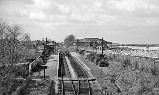
Fairford railway station served the town of Fairford in Gloucestershire. It was the western terminus of the Oxford, Witney and Fairford Railway between Oxford and Fairford. It had one platform, and a stone-built station building.

The Fairford River is a river of Manitoba, Canada. It flows out of the North end of Lake Manitoba into Lake Pineimuta and Lake St. Martin. Regulation of Lake Manitoba dates back to the late 1890s and in 1961 the dam on the river, the Fairford River Water Control Structure (FRWCS) was completed to control outflows. The 1961 works also included widening and deepening of the channel, particularly between Lake Manitoba and the dam, more than tripling the capacity when the lake is at a level of 248 metres (813 ft) above sea level. In times of low water, outflows from Lake Manitoba into the Fairford River are reduced, while during high water levels the gates of the control structure are open to allow water to run down the river and into Lake Pinemuta and Lake St. Martin before eventually ending up in Lake Winnipeg via the Dauphin River. Using the Fairford Dam, the water levels are to be regulated between 247.0 and 247.7 metres above sea level. The average annual outflow from Lake Manitoba into the Fairford River between 1972 and 2001 was 2.502979 cubic kilometres (2,029,198 acre⋅ft). During the 2011 Assiniboine River flood, at the peak, the Fairford River took on record flows of about 620 cubic metres per second (22,000 cu ft/s).
Pinaymootang First Nation is a First Nations people whose home location is at Fairford, Manitoba on Fairford 50 Reserve. They are situated on Hwy #6 in the Interlake Region of Manitoba about 220 kilometres from Winnipeg. The Rural Municipality of Grahamdale forms most of the reserve's land boundary, although it also has a short border with the Little Saskatchewan First Nation as well as significant lakeshore on Lake St. Martin, which is considered as being outside the reserve. The main settlement on the reserve is located at 51°35′55″N 98°41′32″W.

