
Lake Agassiz was a large proglacial lake that existed in central North America during the late Pleistocene, fed by meltwater from the retreating Laurentide Ice Sheet at the end of the last glacial period. At its peak, the lake's area was larger than all of the modern Great Lakes combined. It eventually drained into what is now Hudson Bay, leaving behind Lake Winnipeg, Lake Winnipegosis, Lake Manitoba, and Lake of the Woods.

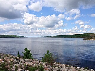
Lake Manitoba is the 14th largest lake in Canada and the 33rd largest lake in the world with a total area of 4,624 square kilometres (1,785 sq mi). It is located within the Canadian province of Manitoba about 75 kilometres (47 mi) northwest of the province's capital, Winnipeg, at 50°59′N98°48′W.

The Red River Floodway is an artificial flood control waterway in Western Canada. It is a 47 km (29 mi) long channel which, during flood periods, takes part of the Red River's flow around the city of Winnipeg, Manitoba to the east and discharges it back into the Red River below the dam at Lockport. It can carry floodwater at a rate of up to 140,000 cubic feet per second (4,000 m3/s), expanded in the 2000s from its original channel capacity of 90,000 cubic feet per second (2,500 m3/s).

The Assiniboine River is a 1,070-kilometre (660 mi) river that runs through the prairies of Western Canada in Saskatchewan and Manitoba. It is a tributary of the Red River. The Assiniboine is a typical meandering river with a single main channel embanked within a flat, shallow valley in some places and a steep valley in others. Its main tributaries are the Qu'Appelle, Souris, and Whitesand Rivers. For early history and exploration see Assiniboine River fur trade.

The Souris River or Mouse River is a river in central North America. Approximately 435 miles (700 km) in length, it drains about 23,600 square miles (61,100 km2) in Canada and the United States.
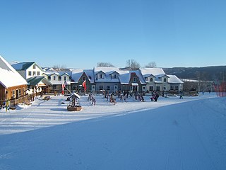
Asessippi Provincial Park is a provincial park in the Rural Municipality of Riding Mountain West, Manitoba, Canada.
Provincial Trunk Highway 6 is a provincial primary highway located in the Canadian province of Manitoba. It runs from the Perimeter Highway of Winnipeg to the Thompson south city limits. It is also the main highway connecting Winnipeg to northern Manitoba. The speed limit is 100 km/h. The route is also used to deliver nickel from the Thompson mine to the Royal Canadian Mint in Winnipeg. The section of highway between its southern terminus near Winnipeg and the second junction with PTH 68 near Eriksdale is part of the Northern Woods and Water Route. The portion of the highway between Ponton and Thompson was known as Highway 391 prior to 1986.

Dauphin Lake is located in western Manitoba near the city of Dauphin. The lake covers an area of 201 square miles (520 km2) and has a drainage basin of about 3,420 square miles (8,900 km2). The Mossy River drains the lake into Lake Winnipegosis. The basin is drained by seven major streams and has a total relief of 1,900 feet (580 m).
The Shellmouth Reservoir is a man-made reservoir on the Assiniboine River in Manitoba and Saskatchewan, Canada.

The Portage Diversion is a water control structure on the Assiniboine River near Portage la Prairie, Manitoba, Canada. The project was made as part of a larger attempt to prevent flooding in the Red River Valley. The Portage Diversion consists of two separate gates which divert some of the flow of water in the Assiniboine River to a 29 km long diversion channel that empties into Lake Manitoba near Delta Beach. This helps prevent flooding on the Assiniboine down river from the diversion, including in Winnipeg, where the Assiniboine River meets the Red River.

The Nelson River Hydroelectric Project refers to the construction of a series of dams and hydroelectric power plants on the Nelson River in Northern Manitoba, Canada. The project began to take shape in the late 1950s, with the planning and construction of the Kelsey dam and hydroelectric power station, and later was expanded to include the diversion of the upper Churchill River into the Nelson River and the transformation of Lake Winnipeg, the world's 11th largest freshwater lake, into a hydroelectric reservoir. The project is owned and operated by Manitoba Hydro, the electrical utility in the province.
The Nillahcootie Dam, a rock and earth-fill embankment dam with a unique Gothic arch-shaped crest spillway across the Broken River that is located near Mansfield, in the Alpine region of Victoria, Australia. The dam's purpose is for the supply of potable water and for irrigation. The impounded reservoir is called Lake Nillahcootie.

Lake Wahtopanah, also known as Rivers Reservoir, is a reservoir on the Little Saskatchewan River near the town of Rivers, Manitoba. Its dam is the Rivers Dam.
The Dauphin River is a river of Manitoba, Canada. The Dauphin is part of the connection from Lake Manitoba to Lake Winnipeg. The Fairford River flows from Portage Bay in Lake Manitoba through to Lake St. Martin then the Dauphin River continues north-eastward from Lake St. Martin into Lake Winnipeg. The two streams parallel Manitoba Provincial Road 513 much of the way. The Fairford River passes through the Rural Municipality of Grahamdale in its flow eastward.

Corra Linn Dam is a concrete hydroelectric dam on the Kootenay River between the cities of Castlegar and Nelson, in the West Kootenay region of southern British Columbia.

Pelican Lake is the largest navigable lake in south western Manitoba, Canada. It is about 18 kilometres long and 1.6 kilometres wide, with a surface area of 27.8 square kilometres. Pelican Lake is relatively shallow with a mean depth of 3.8 metres and a maximum of 5.2 metres and holds 108 billion litres when the lake is at a surface water level of 412.0 metres. The lake is regulated, with a normal summer target level of 412.0 metres. The lake is fed by several small waterways, the main one being the Orthez drain. The total drainage area is 686 square kilometres (265 sq mi).

Twin Lakes Beach, also known locally by many as simply Twin Beaches, is a beach and community in the Canadian province of Manitoba. On Lake Manitoba, it is about 100 kilometres (62 mi) north-west of the provincial capital, Winnipeg. Twin Lakes Beach is in both the Rural Municipality of St. Laurent and the Rural Municipality of Woodlands, and it is in the town of St. Laurent.
The 2011 Assiniboine River flood was caused by above average precipitation in Western Manitoba and Saskatchewan. This was a 1 in 300 year flood that affected much of Western Manitoba. The flooding in Manitoba was expected to mostly involve the 2011 Red River Flood but instead the more severe flooding was found on the Assiniboine in the west.

The 2014 Assiniboine River flood was caused by above average precipitation in western Manitoba and Saskatchewan. Unlike most prior floods, this flood was not due to spring runoff, but rather significant rainfall. Flooding and high water involved both the main stem of the Assiniboine River and many of its tributaries including the Qu'Appelle River and the Souris River. The flood came just 3 years after the 2011 Assiniboine River Flood which was considered a 1 in 300 year event. Peak flows along the river for the first crest were generally slightly less than in 2011. However, the second peak on the river has exceeded 2011 levels starting near St. Lazare, Manitoba up to Brandon, Manitoba so far.

Lake St. Martin is a lake in the Interlake region of Manitoba, Canada. The lake is situated between Lake Manitoba and Lake Winnipeg. Lake St. Martin is downstream from the Fairford River with its Fairford River Control Structure. The Fairford River is the only outlet for Lake Manitoba. With the artificially increased flow and limited outflow, Lake St. Martin was turned into a reservoir. The outflow for Lake St. Martin exits through Dauphin River and into Lake Winnipeg, at a lower rate than the water comes in.


