
Lake Manitoba is the 14th largest lake in Canada and the 33rd largest lake in the world with a total area of 4,624 square kilometres (1,785 sq mi). It is located within the Canadian province of Manitoba about 75 kilometres (47 mi) northwest of the province's capital, Winnipeg, at 50°59′N98°48′W.
Lake Winnipegosis is a large (5,370 km2) lake in central North America, in Manitoba, Canada, some 300 km northwest of Winnipeg. It is Canada's eleventh-largest lake.

The Red River Floodway is an artificial flood control waterway in Western Canada. It is a 47 km (29 mi) long channel which, during flood periods, takes part of the Red River's flow around the city of Winnipeg, Manitoba to the east and discharges it back into the Red River below the dam at Lockport. It can carry floodwater at a rate of up to 140,000 cubic feet per second (4,000 m3/s), expanded in the 2000s from its original channel capacity of 90,000 cubic feet per second (2,500 m3/s).

The Assiniboine River is a 1,070-kilometre (660 mi) river that runs through the prairies of Western Canada in Saskatchewan and Manitoba. It is a tributary of the Red River. The Assiniboine is a typical meandering river with a single main channel embanked within a flat, shallow valley in some places and a steep valley in others. Its main tributaries are the Qu'Appelle, Souris, and Whitesand Rivers. For early history and exploration see Assiniboine River fur trade.
Winnipeg River is a Canadian river that flows roughly northwest from Lake of the Woods in the province of Ontario to Lake Winnipeg in Manitoba. This river is 235 kilometres (146 mi) long from the Norman Dam in Kenora to its mouth at Lake Winnipeg. Its watershed is 106,500 square kilometres (41,100 sq mi) in area, mainly in Canada. About 29,000 square kilometres (11,000 sq mi) of the watershed is in northern Minnesota, United States.
Provincial Trunk Highway 6 is a provincial primary highway located in the Canadian province of Manitoba. It runs from the Perimeter Highway of Winnipeg to the Thompson south city limits. It is also the main highway connecting Winnipeg to northern Manitoba. The speed limit is 100 km/h. The route is also used to deliver nickel from the Thompson mine to the Royal Canadian Mint in Winnipeg. The section of highway between its southern terminus near Winnipeg and the second junction with PTH 68 near Eriksdale is part of the Northern Woods and Water Route. The portion of the highway between Ponton and Thompson was known as Highway 391 prior to 1986.

Fort La Reine was built in 1738 and is one of the forts of the western expansion directed by Pierre Gaultier de Varennes et de La Vérendrye, first military commander in the west of what is now known as Canada. Located on the Assiniboine River where present day Portage la Prairie, Manitoba, stands, the fort served as a fur trading post. It was also the base of operations for much exploration north and west. From Fort La Reine, explorers made their way to Lake Manitoba and Lake Winnipegosis, Lake Winnipeg and the Saskatchewan River.

The Portage Diversion is a water control structure on the Assiniboine River near Portage la Prairie, Manitoba, Canada. The project was made as part of a larger attempt to prevent flooding in the Red River Valley. The Portage Diversion consists of two separate gates which divert some of the flow of water in the Assiniboine River to a 29 km long diversion channel that empties into Lake Manitoba near Delta Beach. This helps prevent flooding on the Assiniboine down river from the diversion, including in Winnipeg, where the Assiniboine River meets the Red River.
Treaty 2 was entered in to on 21 August 1872 at Manitoba House, Rupertsland, with representatives of the Queen of Great Britain and Ireland. The original Anishinaabe, who were present, constitute Treaty 2 today. It is known that many of the chiefs and leaders within the territory were at the early gathering and after the treaty was agreed to. Those who were not present were represented through Metis until they indicated where they wished their farming reserves to be established. The treaty reaffirmed the inherent rights that the Anishinaabe had prior to European contact, located where southwestern Manitoba is today and a small part of southeastern Saskatchewan.

Division No. 19, also informally known as North East Manitoba, is a census division within the Province of Manitoba, Canada. Unlike in some other provinces, census divisions do not reflect the organization of local government in Manitoba. These areas exist solely for the purposes of statistical analysis and presentation; they have no government of their own.
Delta Marsh consists of an extensive open marsh located near the south shore of Lake Manitoba, approximately 24 km north of the town of Portage la Prairie, Manitoba. The marsh extends for nearly 30 km along the shore of the lake, and has a breadth of up to 4 km. The marsh consists of a network of interconnected shallow bays separated from Lake Manitoba by a wooded barrier dune ridge of 300m to 600m width.
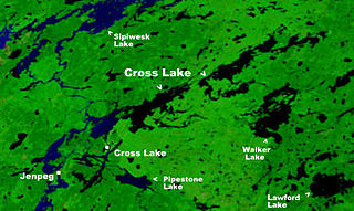
Cross Lake is a large lake in Manitoba on the Nelson River north of Lake Winnipeg. It is long and narrow and extends 102 kilometres (63 mi) east-northeast.

Twin Lakes Beach, also known locally by many as simply Twin Beaches, is a beach and community in the Canadian province of Manitoba. On Lake Manitoba, it is about 100 kilometres (62 mi) north-west of the provincial capital, Winnipeg. Twin Lakes Beach is in both the Rural Municipality of St. Laurent and the Rural Municipality of Woodlands, and it is in the town of St. Laurent.
The 2011 Assiniboine River flood was caused by above average precipitation in Western Manitoba and Saskatchewan. This was a 1 in 300 year flood that affected much of Western Manitoba. The flooding in Manitoba was expected to mostly involve the 2011 Red River Flood but instead the more severe flooding was found on the Assiniboine in the west.
Dauphin River is a community in the Canadian province of Manitoba.

The Fairford River is a river of Manitoba, Canada. It flows out of the north end of Lake Manitoba into Lake Pineimuta and Lake St. Martin.
Pinaymootang First Nation is a First Nations people whose home location is on Fairford 50 Reserve at Fairford in the Rural Municipality of Grahamdale, Manitoba, Canada. They are situated on Provincial Trunk Highway 6 in the Interlake Region of Manitoba about 220 kilometres from Winnipeg. The Rural Municipality of Grahamdale forms most of the reserve's land boundary, although it also has a short border with the Little Saskatchewan First Nation as well as significant lakeshore on Lake St. Martin, which is considered as being outside the reserve. The main settlement on the reserve is located at 51°35′55″N98°41′32″W.

The 2014 Assiniboine River flood was caused by above average precipitation in western Manitoba and Saskatchewan. Unlike most prior floods, this flood was not due to spring runoff, but rather significant rainfall. Flooding and high water involved both the main stem of the Assiniboine River and many of its tributaries including the Qu'Appelle River and the Souris River. The flood came just 3 years after the 2011 Assiniboine River Flood which was considered a 1 in 300 year event. Peak flows along the river for the first crest were generally slightly less than in 2011. However, the second peak on the river has exceeded 2011 levels starting near St. Lazare, Manitoba up to Brandon, Manitoba so far.

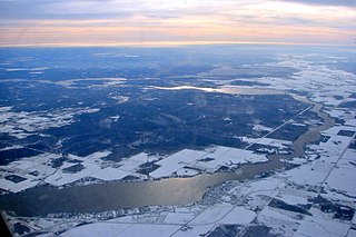
Lake St. Martin is a lake in the Interlake region of Manitoba, Canada. The lake is situated between Lake Manitoba and Lake Winnipeg. Lake St. Martin is downstream from the Fairford River with its Fairford River Control Structure. The Fairford River is the only outlet for Lake Manitoba. With the artificially increased flow and limited outflow, Lake St. Martin was turned into a reservoir. The outflow for Lake St. Martin exits through Dauphin River and into Lake Winnipeg, at a lower rate than the water comes in.