
The IBM 7040 was a historic but short-lived model of transistor computer built in the 1960s.
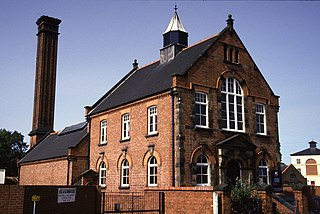
Coleham Pumping Station is a historical pumping station at Coleham in Shrewsbury, England.

Atka Island is the largest island in the Andreanof Islands of the Aleutian Islands of Alaska. The island is 50 miles (80 km) east of Adak Island. It is 65 miles (105 km) long and 2–20 miles (3–30 km) wide with a land area of 404.6 square miles (1,048 km2), making it the 22nd largest island in the United States. The northeast of Atka Island contains the Korovin volcano which reaches a peak of 5,030 feet (1,533 m). Oglodak Island is located 3.4 miles off Cape Kigun, Atka's westernmost point.

Haʻapai is a group of islands, islets, reefs and shoals with an area of 109.30 square kilometres (42.20 sq mi) in the central part of the Kingdom of Tonga, with the Tongatapu group to the south and the Vavaʻu group to the north. Seventeen of the Haʻapai islands are populated with altogether 6,125 people. Its highest point is Kao at almost 1,050 metres (3,440 ft).

The Dominion Arboretum is an arboretum part of the Central Experimental Farm of Agriculture and Agri-Food Canada in Ottawa, Ontario, Canada. Originally begun in 1889, the Arboretum covers about 26 hectares of rolling land between Prince of Wales Drive, Dow's Lake and the Rideau Canal. Carleton University is located at the opposite side of the Canal. At a latitude of 45°, it can experience extremely hot and humid summers and extremely cold winters.

Nomuka is a small island in the southern part of the Haʻapai group of islands in the Kingdom of Tonga. It is part of the Nomuka Group of islands, also called the ʻOtu Muʻomuʻa.

Winslow Reef is an underwater feature of the Phoenix Islands, Republic of Kiribati, located 200 kilometres (120 mi) north-northwest of McKean Island at 01°36′S174°57′W. It is the northernmost and westernmost feature of the Phoenix Islands, not counting the outlying Baker and Howland Islands. It has a least depth of 11 m (36 ft). The reef is about 1.6 km (1 mi) long east-west, and about half that wide. The bottom is pink coral and red sand.
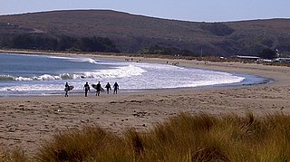
Doran Regional Park is a regional park south of Bodega Bay, California, U.S.A. that is maintained by the Sonoma County Regional Parks Department. It covers an area of 127 acres (51 ha). It is located at 38.314°N 123.0428°W on the sand spit separating Bodega Harbor from Bodega Bay. The park address is 201 Doran Beach Road, Bodega Bay, CA.

The Nootka Fault is an active transform fault running southwest from Nootka Island, near Vancouver Island, British Columbia, Canada.
Winslow Reef is a submerged coral reef of the southern Cook Islands, located 133 kilometres northwest of Rarotonga, at 20°38′S160°56′W. It is a shallow platform reef. No major expeditions to explore Winslow Reef have taken place.
Sagchudak Island is a small island in the Andreanof Islands group in the Aleutian Islands of southwestern Alaska. The roughly rectangular island is approximately 1.4 miles (2.3 km) long and 0.6 mi (1 km) wide and lies about 0.93 mi (1.50 km) off the southern coast of Atka Island. The island's current name is nearly identical to the native Aleut name for the island and it entered navigational charts by the early 1850s. In the 1900s and 1910s, the island was one of many Aleutian islands stocked with foxes by the United States government for hunting and fur trading purposes. Although the foxes on uninhabited Sagchudak were not directly hunted, some were occasionally trapped and moved to and from the island to help ensure genetic stability in the various separated colonies.
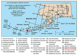
The Aleutian Arc is a large volcanic arc in the U.S. state of Alaska. It consists of a number of active and dormant volcanoes that have formed as a result of subduction along the Aleutian Trench. Although taking its name from the Aleutian Islands, this term is a geologic grouping rather than a geographic one, and the Aleutian Arc extends through the Alaska Peninsula following the Aleutian Range to the Aleutian Islands.
Diamante do Sul is a municipality in the state of Paraná in the Southern Region of Brazil.

ʻOʻua is an island in Lulunga district, in the Haʻapai islands of Tonga. It is suggested that O'Ua is home to approximately 150 inhabitants. There are also different forms of spelling for the name of the island, ʻOʻua is just one of them.

Barrett Glacier is a glacier draining from the north slopes of the Prince Olav Mountains, about 15 nautical miles (30 km) long, flowing between the Longhorn Spurs and the Gabbro Hills to the Ross Ice Shelf. It was named by the Southern Party of the New Zealand Geological Survey Antarctic Expedition (1963–64) for Peter Barrett, a geologist with that party.
Sele, Çubuk is a village in the District of Çubuk, Ankara Province, Turkey.
Gannet Island may refer to:
Spring Hollow Township is an inactive township in Laclede County, in the U.S. state of Missouri.

Kingston and Bourn Old Railway or Kingston Amenity Area is a linear 1.9-hectare (4.7-acre) Local Nature Reserve between Kingston and Bourn in Cambridgeshire, England. It is owned and managed by Cambridgeshire County Council.
This page is based on this
Wikipedia article Text is available under the
CC BY-SA 4.0 license; additional terms may apply.
Images, videos and audio are available under their respective licenses.
