
Burkina Faso is a landlocked country in West Africa with an area of 274,200 km2 (105,900 sq mi), bordered by Mali to the northwest, Niger to the northeast, Benin to the southeast, Togo and Ghana to the south, and the Ivory Coast to the southwest. It has a population of 20,321,378. Previously called Republic of Upper Volta (1958–1984), it was renamed Burkina Faso by President Thomas Sankara. Its citizens are known as Burkinabè, and its capital and largest city is Ouagadougou.

Burkina Faso is a landlocked Sahel country that shares borders with six nations. It lies between the Sahara desert and the Gulf of Guinea, south of the loop of the Niger River, mostly between latitudes 9° and 15°N, and longitudes 6°W and 3°E. The land is green in the south, with forests and fruit trees, and semi-arid in the north. Most of central Burkina Faso lies on a savanna plateau, 198–305 metres (650–1,001 ft) above sea level, with fields, brush, and scattered trees. Burkina Faso's game preserves – the most important of which are Arly, Nazinga, and W National Park—contain lions, elephants, hippopotamus, monkeys, common warthogs, and antelopes. Previously the endangered painted hunting dog, Lycaon pictus occurred in Burkina Faso, but, although the last sightings were made in Arli National Park, the species is considered extirpated from Burkina Faso.

Ivory Coast is a sub-Saharan nation in southern West Africa located at 8 00°N, 5 00°W. The country is approximately square in shape. Its southern border is a 515 km (320 mi) coastline on the Gulf of Guinea on the north Atlantic Ocean. On the other three sides it borders five other African nations for a total of 3,458 km (2,149 mi): Liberia to the southwest for 778 km (483 mi), Guinea to the northwest for 816 km (507 mi), Mali to the north-northwest for 599 km (372 mi), Burkina Faso to the north-northeast for 545 km (339 mi), and Ghana to the east for 720 km (447 mi).

Niger is a landlocked nation in West Africa located along the border between the Sahara and Sub-Saharan regions. Its geographic coordinates are longitude 16°N and latitude 8°E. Its area is 1.267 million square kilometers, of which 1 266 700 km2 is land and 300 km2 water, making Niger slightly less than twice the size of France.
Benin possesses railway and road infrastructure, as well as two seaports. Benin currently does not have rail connections to other countries, but new proposals seek to change this.

The Province de la Kossi lies in the western part of Burkina Faso and stretches to the border with Mali. It is in the Boucle du Mouhoun Region. The capital of Kossi is the town of Nouna, which has a mayor and high commissioner. The next largest town in Kossi is Djibasso, the last major town on the road from Nouna that heads west into Mali.

The Agacher Strip War or Christmas War was a war fought by Burkina Faso and Mali over a 160-kilometre-long (100 mi) strip of land along the border in northern Burkina Faso from 25 to 30 December 1985. The war ended in a ceasefire. The Agacher Strip had been subject to a border dispute between Mali and Burkina Faso since the 1960s. Following armed clashes in 1974, both countries agreed to mediation to resolve their differences. Progress on a solution stalled, and in 1983 Burkinabé President Thomas Sankara and Malian President Moussa Traoré decided to have the border dispute settled by the International Court of Justice and subsequently petitioned the body to resolve the issue.
Ben is a village in the Tansila Department of Banwa Province in western Burkina Faso. As of 2005 it had a population of 901. It lies near the border with Mali.
Liptako is an historic region of West Africa. It today falls in eastern Burkina Faso, southwestern Niger and a small portion of southeast central Mali. A hilly region beginning on the right back of the Niger river, Liptako is usually associated with the Liptako Emirate, an early 19th-century Fulani Islamic state, founded by Brahima Saidu. With the semi nomadic Fula, the main historic population of Liptako are the Gourmantche, a minority population in each of the three nations, as well as the Mossi and Songhai. The other common name for the region, Liptako-Gourma, is a reference to the Gourmantche people.

There are 622 kilometres of 1,000 mmmetre gauge railway in Burkina Faso, which run from Kaya to the border with Côte d'Ivoire and is part of the Abidjan-Ouagadougou railway. As of June 2014, 'Sitarail' operates a passenger train three times a week along the route from Ouagadougou to Abidjan. Journey time is 43 to 48 hours.

Ansar ul Islam is a militant Islamist group active in Burkina Faso and in Mali. It was founded by Boureima Dicko, also known as Ibrahim Malam Dicko, and it is the first native Jihadi group in Burkina Faso. The group cooperates closely with Jama'at Nasr al-Islam wal Muslimin.

On 2 March 2018, at least eight heavily armed militants launched an assault on key locations throughout Ouagadougou, the capital city of Burkina Faso. Targets included the French embassy and the headquarters of Burkina Faso's military.
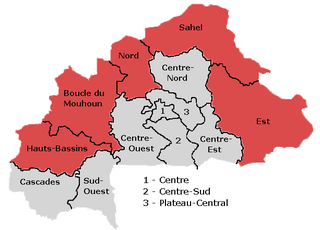
Terrorism in Burkina Faso refers to non-state actor violence in Burkina Faso that is carried out with the intent of causing fear and spreading extremist ideology. Terrorist activity primarily involves religious terrorism conducted by foreign-based organizations, although some activity occurs because of communal frustration over the lack of economic development. Recent attacks are concentrated in the Hauts-Bassins, Boucle du Mouhoun, Nord, Sahel, and Est regions, along the border with Mali and Niger. A series of attacks in Ouagadougou in 2016, 2017, and 2018 by al-Qaeda in the Islamic Maghreb and its affiliates was particularly deadly, garnering international attention.
The Sanmatenga attacks occurred on 8 September 2019 in the Sanmatenga Province, Burkina Faso. In the Barsalogho Department a vehicle transporting people and goods, that was returning from a market, drove over an improvised explosive device (IED). 15 passengers were killed and six were injured in the IED attack. Most of the victims were traders. Meanwhile, around 50 km to the east, a convoy with vans carrying provisions for people displaced by fighting was attacked by gunmen. In this attack, 14 people were killed. It is unknown who carried out this attacks.
The Burkina Faso mosque attack occurred on the evening of Friday, 11 October 2019 in a mosque in Oudalan Province, Burkina Faso which left 16 people dead and two injured. It happened while the residents were praying inside the Grand Mosque in Salmossi, a village close to the border with Mali. AFP reported that 13 people died on the spot while 3 died later due to the injuries.
The Dolmané gold mine attack occurred on 4 October 2019 near Madouji, Arbinda Department, Soum Province, Burkina Faso. The Dolmané gold mining site was attacked by suspected Islamic terrorists. The attack took place not far from where a bridge linking two northern towns was blown up in mid-September. At least 20 persons, mostly people that worked in the gold mine, were killed and an unknown number of people were injured. Both Islamic State and al-Qaeda have affiliated groups in the region. It is unknown which of the two was responsible for this attack.
On 6 November 2019, gunmen ambushed a convoy transporting workers of the Canadian mining firm Semafo near the city of Fada N’Gourma, on a road to the firm's Boungou mine. At least 37 people were killed, and dozens more are missing or injured.
The Jihadist insurgency in Burkina Faso is an ongoing war and civil conflict between the Government of Burkina Faso and Islamist rebels.

Islamist insurgency in the Sahel or Jihadist Insurgencies in the Sahel refers to the Islamist insurgency in the Sahel region of West Africa following the 2011 Arab Spring to the present day. In particular, the intensive conflict in the three countries of Mali, Niger and Burkina Faso has been referred to as the Sahel War.


