Farley Hill is a national park in Saint Peter, Barbados. It is on the site of Grenade Hall Plantation, established in the seventeenth century. [1]
Farley Hill is a national park in Saint Peter, Barbados. It is on the site of Grenade Hall Plantation, established in the seventeenth century. [1]

The parish of Christ Church is one of eleven historic political divisions of Barbados. It has a land area of 57 km2 (22 sq mi) and is found at the southern end of the island. Christ Church has survived by name as one of the original six parishes created in 1629 by Governor Sir William Tufton.

Saint Andrew is one of eleven parishes of Barbados. It is situated in the northeastern area in the country.

The parish of Saint James is an area located in the western central part of the country of Barbados. Increasingly St. James is becoming known as the playground of the rich and famous, and as a haven for sun-starved tourists with its up-market hotel resorts.

The Parish of Saint Peter is one of eleven parishes in the Caribbean island country of Barbados. It is named after the Christian Apostle and patron saint, Saint Peter. It is located in the north of Barbados, and is the only parish besides Saint Lucy that extends from the east coast to the west.
Farley Hill may be a reference to:

Foul Bay refers to a bay, beach, and village in Saint Philip Parish, alongside the southeast coast of Barbados.
Six Men's Bay is a fishing village located to the south of Maycock's Bay in the northwest of Barbados, north of the town of Speightstown. Just off shore of the bay, ini 60 ft of water, rests the 165 ft long wreck of a sunken freighter named Pamir, a spot for scuba diving.
Breedy's is a village in the parish of Saint Andrew in Barbados.

Cherry Tree Hill is a village in the parish of Saint Andrew in Barbados. It is approximately 850 ft. above sea level. It is believed that cherry trees lined the hill at some point, which has since been replaced by mahogany trees. The village overlooks the Scotland District.

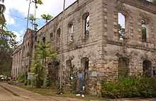
All Saints' Anglican Church is a historic Church located at Pleasant Hall, Saint Peter, Barbados. The original church dates back to 1649 when a chapel was established to 'ease' the then colonial settlers from having to venture to the St. James Parish Church and the St. Peter's Parish Church. This original church was destroyed by the Great Hurricane of 1831. A second church was built in 1839, but was pulled down as unsafe forty years later after structural faults were discovered. The church is known for having detailed stained glass, the main show piece being the eastern detail, a donation from Thomas Briggs in memory of his parents Sir and Lady Graham Briggs, owners of the Grenade Hall Plantation which at the time included the Farley Hill Great House. Buried within the 16th Century church yard is the first English settler to set foot on Barbadian soil, William Arnold. The present church was built and consecrated in 1884. The present Rector is Father Selven Lowe.

The following outline is provided as an overview of and introduction to Barbados:
Hopewell is a settlement in Saint Thomas Parish, Barbados.

The Barbados Wildlife Reserve is located in the parish of Saint Peter, Barbados. It occupies four acres of mahogany forest near the top of Farley Hill, next to Grenade Hall Signal Station and Forest.

Vainupea is a village in Haljala Parish, Lääne-Viru County, in northern Estonia, on the territory of Lahemaa National Park. The village includes the island of Vaindloo, making it the northernmost settlement in Estonia.

Bottom Bay is a bay located in Saint Philip, Barbados, with Palmetto Bay to the north, and Cave Bay, Crane Beach and Sam Lord's Castle to the south.
Blue Waters is a populated place in the parish of Christ Church, Barbados. It is a coastal area located on the south coast of Barbados. Rockley Beach is a beach located in Blue Waters.
Diamond Corner is a populated place in the parish of Saint Peter, Barbados.
Pie Corner is a community in the parish of Saint Lucy, Barbados. It is located in the North Eastern region of the parish.
| | This Barbados location article is a stub. You can help Wikipedia by expanding it. |