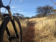
A trail, also known as a path or track, is an unpaved lane or a small paved road not intended for usage by motorized vehicles, usually passing through a natural area. In the United Kingdom and the Republic of Ireland, a path or footpath is the preferred term for a pedestrian or hiking trail. The term is also applied in North America to accompanying routes along rivers, and sometimes to highways. In the US, the term was historically used for a route into or through wild territory used by explorers and migrants. In the United States, "trace" is a synonym for trail, as in Natchez Trace.

The Welland Recreational Waterway is a water channel in the city of Welland, Ontario, Canada. It is an old alignment of the Welland Ship Canal that was abandoned after the construction of the Welland By-Pass in the 1970s. The Waterway is now managed by the Welland Recreational Canal Corporation to provide enjoyment for the city's residents. Most local residents refer to it as the old canal or simply the canal.
Bartram Forest Wildlife Management Area is a 2,113-acre (9 km2) state land tract in Baldwin County and Wilkinson County, Georgia, United States. The forest was named in honor of naturalists John Bartram (1699-1777) and his son William Bartram (1739-1823).

Montaña de Oro is a state park in Central Coastal California, six miles southwest of Morro Bay and two miles south of Los Osos.

Rothrock State Forest is a Pennsylvania state forest in Pennsylvania Bureau of Forestry District #5. The main offices are located in Huntingdon in Huntingdon County, Pennsylvania in the United States.

Long Lake Provincial Park is located in Halifax, Nova Scotia, Canada. It was initiated in 1981 by then Premier John Buchanan after Halifax's water supply had been shifted from the Spruce Hill/Long Lake/Chain Lakes watershed to the Pockwock Lake watershed near Hammonds Plains. The 2,095-hectare (5,180-acre) park, formally established in 1984, constitutes the bulk of these former watershed lands. Other portions were deeded to the municipality of Halifax, and the area around the Chain Lakes is still administered by the Halifax Regional Water Commission, since the Chain Lakes remain the city's emergency water supply.

Park City Mountain Resort (PCMR) is a ski resort in the western United States in Park City, Utah, located 32 miles (51 km) east of Salt Lake City. Park City, as the ski resort and area is known, contains several training courses for the U.S. Ski Team, including slalom and giant slalom runs. During the 2002 Winter Olympics, it hosted the snowboarding events and the men's and women's alpine giant slalom events.
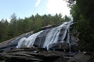
DuPont State Recreational Forest, commonly known as DuPont Forest, is a 12,500-acre (51 km2) state forest, located in Henderson and Transylvania counties of North Carolina. The name originates from the fact that the DuPont company arranged the sale of the original tract to the state. Adjacent tracts have since been purchased and added to the state forest. Portions of the forest formerly contained a manufacturing facility for the production of X-ray film. The forest was used to shoot scenes from the 1992 film The Last of the Mohicans as well as the 2012 box office hit The Hunger Games. On February 12, 2019, the forest added 402 acres (1.63 km2) from Conserving Carolina, part of a section called the Continental Divide Tract that connects with other public lands. 314 more acres was added to the forest in 2019.

Solitaire is a small settlement in the Khomas Region of central Namibia near the Namib-Naukluft National Park. It currently features the only gasoline station, bakery, cafe, and the only general dealer between the dunes at Sossusvlei and the coast at Walvis Bay, as well as on the road to the capital Windhoek. Solitaire belongs to the Windhoek Rural electoral constituency.

Shelby Farms is a public park located in Shelby County, Tennessee, United States, just east of the city of Memphis. It is one of the largest urban parks in the US and the world, at a size of 4,500 acres (1,800 ha) and covers more than five times the area of Central Park in New York City with 843 acres (341 ha).
Evansburg State Park is a 3,349-acre (1,355 ha) Pennsylvania state park in Lower Providence, Lower Salford, Skippack, Towamencin, and Worcester Townships in Montgomery County, Pennsylvania in the United States. The park has a variety of habitats including forests, meadows, old fields, and farmlands. The park offers a variety of recreational opportunities including picnicking, golf, ball fields, biking, hiking, hunting, horseback riding, and fishing. Evansburg State Park is near Collegeville and Norristown just off Pennsylvania Route 363.

Pinckney State Recreation Area is a Michigan state recreation area in Dexter, Sylvan and Lyndon Townships, Washtenaw County and Putnam and Unadilla Townships, Livingston County in the U.S. state of Michigan. The park is 11,000 acres (4,500 ha) and sits at an elevation of 922 feet (281 m). The park is connected to the nearby Waterloo State Recreation Area by the 35-mile (56 km) Waterloo–Pinckney Trail. Pinckney State Recreation Area is open for year-round recreation including hiking, fishing, swimming, hunting and a variety of winter sports.

Waterloo State Recreation Area is the third-largest park in Michigan, encompassing over 21,000 acres (85 km2) of forest, lakes and wetlands. Located in northeast Jackson County and parts of Washtenaw County, the park is the largest in the Lower Peninsula of Michigan and features 4 campgrounds, 11 lakes, a nature center, and over 50 miles (80 km) of trails - some for horses, bicycles, hiking and cross-country skiing. Waterloo SRA includes the Black Spruce Bog Natural Area, a National Natural Landmark and borders the 11,000-acre (45 km2) Pinckney Recreation Area on the east and the 950-acre (3.8 km2) Phyllis Haehnle Memorial Audubon Sanctuary to the west. The land preserved by the park is not all contiguous and numerous private landholdings and roads run through the park area. The area is characterized by moraines, kettle lakes, swamps and bogs left by retreating glaciers after the last ice age. The park was created by the federal government during the Great Depression and is long-term leased to the state.
Noon Hill and Shattuck Reservation are adjacent open space preserves located in Medfield, Massachusetts. They are managed by the land conservation non-profit organization The Trustees of Reservations. The 200-mile (320 km) Bay Circuit Trail passes through both properties. The Town of Medfield owns conservation land adjacent to the properties.

Lost Dutchman State Park is a 320-acre (129 ha) state park located in northwestern Pinal County, Arizona on the Apache Trail north of Apache Junction, near the Superstition Mountains in central Arizona. It is named after the Lost Dutchman's Gold Mine, a famously lost gold mine legendary in the tales of the Old West. It is accessible about 40 miles (64 km) east of Phoenix via U.S. Highway 60, the Superstition Freeway.
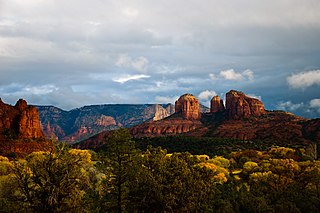
Red Rock State Park is a state park of Arizona, United States, featuring a red sandstone canyon outside the city of Sedona. The main mission of this day-use park is the preservation of the riparian habitat along Oak Creek. Red Rock State Park serves as an environmental education facility for the public and for school or private groups, and provides limited passive recreational opportunities.

Croft State Park is a state park in Spartanburg County, South Carolina, located on land used during World War II as Camp Croft, a US Army basic training center and prisoner-of-war camp.

Hollenbeck Canyon Wildlife Area is located near Jamul and Dulzura in California. The former cattle ranch was designated a wildlife area in 2001, and forms a wildlife corridor between Otay Mountain Wilderness and Jamul Mountains under the protection of the California Department of Fish and Wildlife. The approximately 6,100-acre area is open to the public for activities including hunting, equestrian use, hiking, mountain-biking, and (hunting) dog training.
Ferncliff Forest is a 200-acre (0.81 km2) old-growth forest preserve of deciduous and hemlock trees located in Rhinebeck, a town in the northern part of Dutchess County, New York, USA. The property had been bought in 1900 by John Jacob Astor IV and remained in the Astor family until 1964, when it was donated as a forest preserve and game refuge.
Seven Bends State Park is a state park in the U.S. state of Virginia, located approximately 2 miles (3.2 km) from the town of Woodstock, near the historic "Seven Bends" region of the North Fork Shenandoah River. The park, Virginia's 41st, provides recreational and land-based outdoor recreational and educational opportunities for visitors while protecting the natural resources of the river and the surrounding landscape.