
Kallang is a planning area and residential zone located in the Central Region of Singapore.

The Kallang River is the longest river in Singapore, flowing for 10 kilometers from the Lower Peirce Reservoir to the Kallang Basin. It originates in the planning area of Central Water Catchment, flows in a southeast direction through Bishan and Toa Payoh, before finally arriving in Kallang.
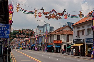
Little India is an ethnic district in Singapore. It is located east of the Singapore River – across from Chinatown, located west of the river – and north of Kampong Glam. Both areas are part of the urban planning area of Rochor. Little India is commonly known as Tekka in the Indian Singaporean community.

Farrer Park MRT station is an underground Mass Rapid Transit (MRT) station along the North East line, located on the boundary of Kallang and Rochor planning areas, Singapore. It is one of the two stations that serve the ethnic district of Little India. The station sits underneath the Connexion building, an integrated hospital and hotel complex.

Lavender MRT station is an underground Mass Rapid Transit (MRT) station on the East West line in Kallang, Singapore. Located under Kallang Road, the station is close to the Immigration and Checkpoints Authority (ICA) Building, Golden Mile Complex and Jalan Besar Stadium. Planned and built as part of Phase Two of the original MRT network, the contract for the station's construction was awarded in October 1985, and it was opened in November 1989.

Kallang Basin is an enclosed bay in Kallang, Singapore. The Kallang River, Rochor River and Geylang River empty into the Kallang Basin. The Marina Channel connects the Kallang Basin with the Singapore Straits.

Tanjong Rhu is a subzone within the planning area of Kallang, Singapore, as defined by the Urban Redevelopment Authority (URA). The perimeter of Tanjong Rhu is made up of Nicoll Highway in the north; Mountbatten Road and Fort Road in the east; East Coast Parkway (ECP) in the south; as well as Marina Channel and Kallang Basin in the west. Tanjong Rhu is the largest in terms of physical area among the nine subzones that make up Kallang.

North Bridge Road is a one-way road in Singapore, running north of the Singapore River. It starts at the junction with Crawford Street in Kallang, on the western bank of the Rochor River, and continues in a southwest direction before ending at Elgin Bridge. The stretch south of the Singapore River after Elgin Bridge is called South Bridge Road. En route, North Bridge Road travels through the planning areas of Kallang, Rochor and the Downtown Core.

Beach Road is a road located within the planning areas of Kallang, Rochor and the Downtown Core in Singapore.

Newton is a town that is located within the Central Area of the Central Region of Singapore. The planning area is bounded by the following planning areas - Orchard and Museum to the south, Tanglin to the west, Novena to the north, Kallang to the northeast and Rochor to the east.
Farrer Park is a subzone of the Rochor planning area in the Central Region of Singapore, as defined by the Urban Redevelopment Authority bounded by Serangoon Road, Rangoon Road, Race Course Road, Northumberland Road, Tekka Lane and Bukit Timah Road.

Nicoll Highway is a major arterial road in Singapore which links the junctions of Guillemard Road, Sims Way and Mountbatten Road in Kallang to the junctions of Esplanade Drive, Raffles Avenue and Stamford Road in the city. En route, it passes through the areas of Kallang, Kampong Glam and Marina Centre.
The Rochor River is a canalised river in Kallang of the Central Region in Singapore. The river is about 0.8 km in length.

Rochor is a planning area located within the Central Area of the Central Region of Singapore. Rochor shares boundaries with the following planning areas – Kallang to the north and east, Newton to the west, as well as Museum and the Downtown Core to the south.

Kallang Riverside Park is a riverine park in Kallang, Singapore. It sits on the confluence of the Kallang River and Rochor River, north of the Kallang Basin.

Lavender is a subzone within the planning area of Kallang, Singapore, as defined by the Urban Redevelopment Authority (URA). Lavender is composed of an area bounded by Tessensohn Road in the north; Balestier Road, Lavender Street and Crawford Street in the east; the Rochor River and Rochor Canal in the south; as well as Syed Alwi Road, Serangoon Road and Rangoon Road in the west.

Kampong Bugis is a subzone within the planning area of Kallang, Singapore, as defined by the Urban Redevelopment Authority (URA). This subzone is bounded by Kallang Road and Sims Avenue in the north; the Kallang–Paya Lebar Expressway (KPE) and Sims Way in the east; Nicoll Highway in the south; and Crawford Street in the west.

Crawford is a subzone within the planning area of Kallang, Singapore, as defined by the Urban Redevelopment Authority (URA). Its perimeter is made up of Rochor River and Rochor Canal in the north; Crawford Street, Nicoll Highway, Kallang Basin and Marina Channel in the east; East Coast Parkway (ECP) in the south; as well as Ophir Road, Beach Road and Jalan Sultan in the west.
Kallang Gasworks was the first site dedicated to gas manufacturing from coal in Singapore. It operated from 1862 to 23 March 1998.
Farrer Park Field is an open field managed by Sport Singapore in Kallang, Singapore. It was the location of Singapore's first race course, Serangoon Road Race Course, as well as where its first-ever aircraft landing took place in 1919. It is a significant location for Singapore's aviation, sporting and political histories.