Related Research Articles

The Shebaa Farms, also spelled Sheba'a Farms, also known as Mount Dov, is a strip of land on the Lebanese–Syrian border that is currently occupied by Israel. Lebanon claims the Shebaa Farms as its own territory, and Syria agrees with this position. Israel claims it is part of the Golan Heights, Syrian territory that it has occupied since 1967 and effectively annexed in 1981. This dispute plays a significant role in contemporary Israel–Lebanon relations.

The Gaza–Israel barrier is a border barrier located on the Israeli side of the Gaza–Israel border. Before the Israel–Hamas war, the Erez Crossing, in the north of the Gaza Strip, used to be the only crossing point for people and goods coming from Israel into the Gaza Strip. A second crossing point, the Kerem Shalom border crossing, is used exclusively for goods coming from Egypt as Israel did not allow goods to go directly from Egypt into Gaza through the Egypt–Gaza border, except for the Salah Al Din Gate, which opened in 2018.

The United Nations Interim Force in Lebanon, or UNIFIL, is a United Nations peacekeeping mission established on 19 March 1978 by United Nations Security Council Resolutions 425 and 426, and several further resolutions in 2006 to confirm Hezbollah demilitarisation, support Lebanese army operations against insurgents and weapon smuggling, and confirming Israeli withdrawal from Lebanon, in order to ensure that the government of Lebanon would restore its effective authority in the area. The 1978 South Lebanon conflict came in the context of Palestinian insurgency in South Lebanon and the Lebanese Civil War.

The Green Line was a line of demarcation in Beirut, Lebanon, during the Lebanese Civil War from 1975 to 1990. It separated the mainly Muslim factions in predominantly Muslim West Beirut from the predominantly Christian East Beirut controlled by the Lebanese Front. However, as the Civil War continued, it also came to separate Sunni from Shia. At the beginning of the Civil War, the division was not absolute as some Muslims lived East of the Green Line and some Christians lived in West Beirut; but, as the Civil War continued, each sector became more homogeneous as minorities left the sector they were in. The appellation refers to the coloration of the foliage that grew because the space was uninhabited. While most commonly referred to as the "Green Line", it was also sometimes called the "Demarcation Line". It generally stretched from the North of Beirut to the South, and the primary street that followed the Green Line was Damascus Street. There was no formal line or continual security but it was common to see militia checkpoints that people crossing at particular points had to go through and snipers on top of buildings were common. Many of the buildings along the Green Line were severely damaged or destroyed during the war. Since the end of hostilities, however, many of the buildings have been rebuilt within the framework of the urban renewal project of Solidere in Centre Ville (Downtown).

The Good Fence was a term that referred to Israel's mountainous 129-kilometre (80 mi) northern border with Lebanon during the period following the 1978 South Lebanon conflict, during the Lebanese Civil War. At the time, southern Lebanon was controlled by the Maronite Christian militias and the South Lebanon Army, as the Free Lebanon State (1978–1984) and later the South Lebanon security belt administration.
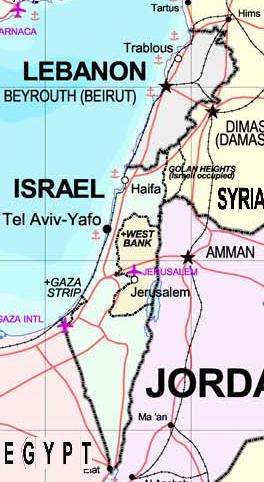
The Israeli–Lebanese conflict, or the South Lebanon conflict, is a long-running conflict involving Israel, Lebanon-based paramilitary groups, and sometimes Syria. The conflict peaked during the Lebanese Civil War. In response to Palestinian attacks from Lebanon, Israel invaded the country in 1978 and again in 1982. After this it occupied southern Lebanon until 2000, while fighting a guerrilla conflict against Shia paramilitaries. After Israel's withdrawal, Hezbollah attacks sparked the 2006 Lebanon War. A new period of conflict began in 2023, leading to the 2024 Israeli invasion of Lebanon.

The United Nations Disengagement Observer Force (UNDOF) is a United Nations peacekeeping mission tasked with maintaining the ceasefire between Israel and Syria in the aftermath of the 1973 Yom Kippur War. The mission was established by United Nations Security Council Resolution 350 on 31 May 1974, to implement Resolution 338 (1973) which called for an immediate ceasefire and implementation of United Nations Security Council Resolution 242.
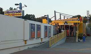
Kiryat Haim railway station is an Israel Railways passenger station serving Haifa's borough of Kiryat Haim and its immediate surrounding region.

United Nations Security Council Resolution 1701 is a resolution that was intended to resolve the 2006 Lebanon War. The resolution calls for a full cessation of hostilities between Israel and Hezbollah, the withdrawal of Hezbollah and other forces from Lebanon south of the Litani, the disarmament of Hezbollah and other armed groups, and the withdrawal of Israeli forces from Lebanon, with no armed forces other than UNIFIL and Lebanese military south of the Litani River, which flows about 29 km (18 mi) north of the border. It emphasizes Lebanon's need to fully exert government control and calls for efforts to address the unconditional release of abducted Israeli soldiers.

The Khiam detention center was an army barracks complex originally used by the French military in the 1930s in Khiam, French Lebanon. Following the establishment of independent Lebanon in 1946, it was used by the Lebanese military until the outbreak of the Lebanese Civil War in 1975, during which time it came under the control of the South Lebanon Army (SLA), an Israel-backed Lebanese Christian militia. With the beginning of the South Lebanon conflict in 1985, the base was converted into a prisoner-of-war camp and used to hold captured anti-Israel activists and militants. Those were mainly members of the Lebanese Communist Party, the Amal movement, and other leftist organizations. The facility remained in use in this capacity until Israel's withdrawal from Lebanon in May 2000 and the subsequent collapse of the SLA. After the Israeli withdrawal, the camp was preserved in the condition it was abandoned in, and converted into a museum by the Lebanese government.

Tegart's Wall was a barbed wire fence erected in May–June 1938 by British Mandatory authorities in the Upper Galilee near the northern border of the territory in order to keep militants from infiltrating from French-controlled Mandatory Lebanon and Syria to join the 1936–1939 Arab revolt in Palestine. With time the security system further included police forts, smaller pillbox-type fortified positions, and mounted police squads patrolling along it. It was described as an "ingenious solution for handling terrorism in Mandatory Palestine."

The Upper Galilee Regional Council is a regional council in Israel's Upper Galilee region, bordered by the Mevo'ot HaHermon Regional Council and the Golan Regional Council, as well as a border with southern Lebanon.

Kampong Trach District is one of 8 districts in Kampot Province and it is located at the eastern part bordering Vietnam to the east, Banteay Meas District to the north, Kep Province to the west and the Gulf of Thailand to the south.

The Galilee panhandle (Hebrew: אצבע הגליל, Etzba HaGalil, is an elongated geopolitical area or "panhandle" in northern Israel comprising the northernmost section of the Upper Galilee, and the northern Jordan Rift Valley. The Galilee Panhandle incorporates five municipal authorities. Towns in the Galilee panhandle include Metula and Kiryat Shmona.
The 2005 Hezbollah cross-border raid was a failed attempt by Hezbollah to abduct Israel Defense Forces (IDF) soldiers. It was the largest operation of this type mounted prior to the 2006 Lebanon War.

The Israeli occupation of Southern Lebanon lasted for eighteen years, from 1982 until 2000. In June 1982, Israel invaded Lebanon in response to attacks from southern Lebanon by Palestinian militants. The Israel Defense Forces (IDF) occupied the southern half of Lebanon as far as the capital city Beirut, together with allied Maronite Christian paramilitaries involved in the Lebanese Civil War. The IDF left Beirut on 29 September 1982, but continued to occupy the country's southern half. Amid rising casualties from guerrilla attacks, the IDF withdrew south to the Awali river on 3 September 1983.

The commemorative stelae of Nahr el-Kalb are a group of over 20 inscriptions and rock reliefs carved into the limestone rocks around the estuary of the Nahr al-Kalb in Lebanon, just north of Beirut.
The State of Free Lebanon was an unrecognized separatist country in Lebanon. On 18 April 1979, Lebanese military officer Saad Haddad proclaimed the independence of a "Free Lebanon" out of the southernmost territory of Lebanon, amidst the hostilities of the Lebanese Civil War. Haddad was the founding commander of the South Lebanon Army, a quasi-military that aimed to serve the political interests of Lebanon's Maronite Christians during the conflict.

The Lebanon–Syria border is 394 km in length and runs from the Mediterranean coast in the north to the tripoint with Israel in the south.

The Jordan–Syria border is 362 km in length and runs from the tripoint with Israel in the west to the tripoint with Iraq in the east.
References
- ↑ Frayer, Lauren (19 August 2006). "South Lebanon has seen violence for nearly 40 years". Fatima Gate, Lebanon: ASSOCIATED PRESS. Retrieved 5 October 2006.
- ↑ Report of the Secretary-General on the United Nations Interim Force in Lebanon