Overview of the Federal Land Policy and Management Act
The FLPMA changed the way that the federal government managed lands and the resources on those lands by providing the Bureau of Land Management more control over the acquisition and disposal of land and by creating a detailed plan that analyzed the environmental concerns of federal land. The act greatly increased the power of the Bureau of Land Management in the Department of the Interior to acquire and dispose of federal land. [4] The FLPMA required a plan to be created for land to determine the environmental value of that land and if it could be designated for public use. [5] The plan would detail the environmental concerns of the land, requiring that three factors be upheld:
- The land must be managed in a way that protects the integrity of the natural resources and cultural or historical artifacts found on the land. [5]
- Segments of the land that were deemed to be in danger or vital had to be protected. [5]
- Any sections of the land that had environmental significance be established. [5]
The Bureau of Land Management had to follow these requirements when making any decisions regarding the management of federal land that was intended for public use.
Congress recognized the value of the public lands, declaring that these lands would remain in public ownership. The National Forest Service, National Park Service, and now, the Bureau of Land Management, are commissioned in FLPMA to allow a variety of uses on their land (of greater concern for the BLM, who is the least restrictive in terms of uses) while simultaneously trying to preserve the natural resources in them. This concept is best summarized by the term 'multiple-use.' 'Multiple use' is defined in the Act as "management of the public lands and their various resource values so that they are utilized in the combination that will best meet the present and future needs of the American people." FLPMA addresses topics such as land-use planning, land acquisition, fees and payments, administration of federal land, range management, and right-of-ways on federal land. FLPMA has specific objectives and time frames in which to accomplish these objectives, giving it more authority and eliminating the uncertainty surrounding the BLM's role in wilderness designation and management.
Parts of FLPMA relating specifically to Wilderness are found in Subchapter VI Designated Management Areas (§§ 1781 to 1787) under 43 U.S. Code § 1782 - Bureau of Land Management Wilderness Study. Here, the BLM is also given a mandate to recommend areas for designation as Wilderness and are given 15 years to do so. The BLM is to conduct studies, classifying areas as Wilderness Study Areas. These areas are not official Wilderness areas but are, for all intents and purposes, treated as such until formally designated as Wilderness or released by Congress. Approximately 8.8 million acres of BLM wilderness are currently included in the National Wilderness Preservation System as a result of the wilderness reviews mandated by FLPMA. Those ordered to implement policies from FLPMA are trained government employees using guidelines expressly stated within the act itself.

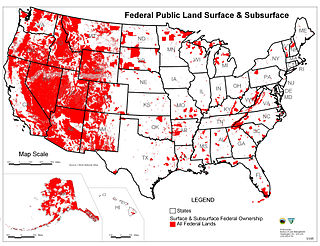
The Bureau of Land Management (BLM) is an agency within the United States Department of the Interior responsible for administering U.S. federal lands. Headquartered in Washington, D.C., the BLM oversees more than 247.3 million acres (1,001,000 km2) of land, or one-eighth of the United States's total landmass.

The Grand Staircase–Escalante National Monument (GSENM) is a United States national monument protecting the Grand Staircase, the Kaiparowits Plateau, and the Canyons of the Escalante in southern Utah. It was established in 1996 by President Bill Clinton under the authority of the Antiquities Act with 1.7 million acres of land, later expanded to 1,880,461 acres (7,610 km2). In 2017, the monument's size was reduced by half in a succeeding presidential proclamation, and it was restored in 2021. The land is among the most remote in the country; it was the last to be mapped in the contiguous United States.
In all modern states, a portion of land is held by central or local governments. This is called public land, state land, or Crown land. The system of tenure of public land, and the terminology used, varies between countries. The following examples illustrate some of the range.

The General Mining Act of 1872 is a United States federal law that authorizes and governs prospecting and mining for economic minerals, such as gold, platinum, and silver, on federal public lands. This law, approved on May 10, 1872, codified the informal system of acquiring and protecting mining claims on public land, formed by prospectors in California and Nevada from the late 1840s through the 1860s, such as during the California Gold Rush. All citizens of the United States of America 18 years or older have the right under the 1872 mining law to locate a lode or placer (gravel) mining claim on federal lands open to mineral entry. These claims may be located once a discovery of a locatable mineral is made. Locatable minerals include but are not limited to platinum, gold, silver, copper, lead, zinc, uranium and tungsten.
The General Land Office (GLO) was an independent agency of the United States government responsible for public domain lands in the United States. It was created in 1812 to take over functions previously conducted by the United States Department of the Treasury. Starting with the enactment of the Land Ordinance of 1785, which created the Public Land Survey System, the Treasury Department had already overseen the survey of the Northwest Territory, including what is now the state of Ohio.

The Sagebrush Rebellion was a movement in the Western United States in the 1970s and the 1980s that sought major changes to federal land control, use, and disposal policy in 13 western states in which federal land holdings include between 20% and 85% of a state's area. Supporters of the movement wanted more state and local control over the lands, if not outright transfer of them to state and local authorities and/or privatization. As much of the land in question is sagebrush steppe, supporters adopted the name "Sagebrush Rebellion."
Federal lands are publicly owned lands in the United States managed by the federal government. Pursuant to the Property Clause of the United States Constitution, Congress has the power to retain, buy, sell, and regulate federal lands, such as by limiting cattle grazing on them. These powers have been recognized in a long series of United States Supreme Court decisions.
The Wilderness Act of 1964 was written by Howard Zahniser of The Wilderness Society. It created the legal definition of wilderness in the United States, and protected 9.1 million acres (37,000 km²) of federal land. The result of a long effort to protect federal wilderness and to create a formal mechanism for designating wilderness, the Wilderness Act was signed into law by President Lyndon B. Johnson on September 3, 1964 after over sixty drafts and eight years of work.

The National Wilderness Preservation System (NWPS) of the United States protects federally managed wilderness areas designated for preservation in their natural condition. Activity on formally designated wilderness areas is coordinated by the National Wilderness Preservation System. Wilderness areas are managed by four federal land management agencies: the National Park Service, the U.S. Forest Service, the U.S. Fish and Wildlife Service, and the Bureau of Land Management.
National Conservation Lands, formally known as the National Landscape Conservation System, is a 35-million-acre (140,000 km2) collection of lands in 873 federally recognized areas considered to be the crown jewels of the American West. These lands represent 10% of the 258 million acres (1,040,000 km2) managed by the Bureau of Land Management (BLM). The BLM is the largest federal public land manager and is responsible for over 40% of all the federal public land in the nation. The other major federal public land managers include the US Forest Service (USFS), National Park Service (NPS), and the US Fish and Wildlife Service (USFWS).

A wilderness study area (WSA) contains undeveloped United States federal land retaining its primeval character and influence, without permanent improvements or human habitation, and managed to preserve its natural conditions. In spite of this, WSAs are not included in the National Wilderness Preservation System.

The National Wildlife Refuge System in the United States has a long and distinguished history.

The King Range Wilderness is a 42,585-acre (172 km2) federally designated wilderness area within the King Range National Conservation Area in northern California, United States. The area was set aside with the passage of the Northern California Coastal Wild Heritage Wilderness Act of 2006. The Bureau of Land Management is the responsible agency and is currently working on a Management Plan for the King Range Wilderness. This section of California's coastline is known as the "Lost Coast", a landscape too rugged for highway building, which forced the construction of State Highway 1 and U.S. 101 inland. The King Range Wilderness is the longest undeveloped coast, outside of Alaska, in the United States.
Starting in 1876, and undergoing a series of name changes, the United States Forest Service grew to protect and use millions of acres of forest on public land. Gifford Pinchot, an early advocate of scientific forestry, along with President Theodore Roosevelt and conservation organizations, led the effort to manage forest for the public good.
The California Desert Protection Act of 2010 was legislation proposed by U.S. Senator Dianne Feinstein. The stated aim of the legislation was "to provide for conservation, enhanced recreation opportunities, and development of renewable energy in the California Desert Conservation Area."

The California Desert Protection Act of 1994 is a federal law sponsored by Senator Dianne Feinstein, passed by the United States Congress on October 8, 1994, and signed into effect by President Bill Clinton on October 31 of the same year, that established three separate National Park System units in California's Mojave Desert: Death Valley National Park, Joshua Tree National Park, and Mojave National Preserve.
Sleeping Giant Wilderness Study Area is a non-motorized recreation area located on the west side of the Missouri River and Holter Lake located about 30 miles (48 km) north of Helena, Montana. Designated as a wilderness study area in 1981, the Sleeping Giant Wilderness Study Area contains approximately 6,666 acres (2,698 ha) of nearly roadless land, about half of which is forested. A portion of the Lewis and Clark National Historic Trail is contained inside the study area.
The Wild and Free-Roaming Horses and Burros Act of 1971 (WFRHBA), is an Act of Congress, signed into law by President Richard M. Nixon on December 18, 1971. The act covered the management, protection and study of "unbranded and unclaimed horses and burros on public lands in the United States."
The Federal Lands Jobs and Energy Security Act is a bill that would require the Bureau of Land Management (BLM) to establish certain fees for activities related to the development of oil and gas on federal lands. A portion of those amounts along with a portion of fees from renewable energy projects on federal lands would be available to the agency, subject to appropriation, to cover the costs of activities aimed at increasing energy development on federal lands. The bill also would exempt lawsuits related to energy production on federal lands from the Equal Access to Justice Act (EAJA). In addition, the legislation would require the BLM to offer for sale at least 25 percent of onshore federal lands nominated by firms for oil and gas leasing. It was introduced in the United States House of Representatives during the 113th United States Congress. President Barack Obama threatened to veto the bill on November 19, 2013.

Browns Canyon National Monument is a 21,586 acres (87 km2) national monument in Chaffee County, Colorado, that was designated as such by President Barack Obama under the Antiquities Act on February 19, 2015. The site will be centered along the Arkansas River between Buena Vista and Salida. Browns Canyon is the most popular destination for whitewater rafting in the country, and is also known for its fishing and hiking. The monument will provide habitat protection for bighorn sheep, peregrine falcons, elk, and golden eagles.
